
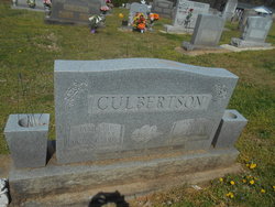
Clara Janet Toney Culbertson
| Birth | : | 18 Sep 1931 Bostic, Rutherford County, North Carolina, USA |
| Death | : | 27 Sep 2005 Forest City, Rutherford County, North Carolina, USA |
| Burial | : | Mount Harmony Baptist Church Cemetery, Bostic, Rutherford County, USA |
| Coordinate | : | 35.4588380, -81.7996940 |
frequently asked questions (FAQ):
-
Where is Clara Janet Toney Culbertson's memorial?
Clara Janet Toney Culbertson's memorial is located at: Mount Harmony Baptist Church Cemetery, Bostic, Rutherford County, USA.
-
When did Clara Janet Toney Culbertson death?
Clara Janet Toney Culbertson death on 27 Sep 2005 in Forest City, Rutherford County, North Carolina, USA
-
Where are the coordinates of the Clara Janet Toney Culbertson's memorial?
Latitude: 35.4588380
Longitude: -81.7996940
Family Members:
Parent

Spouse
Siblings

Flowers:


Nearby Cemetories:
1. Mount Harmony Baptist Church Cemetery
Bostic, Rutherford County, USA
Coordinate: 35.4588380, -81.7996940
2. Ross Hill Baptist Church Cemetery
Bostic, Rutherford County, USA
Coordinate: 35.4575280, -81.7922220
3. Cedar Grove United Methodist Church Cemetery
Rutherford County, USA
Coordinate: 35.4506110, -81.8097540
4. Cooper Springs Congregational Holiness Church Ceme
Rutherford County, USA
Coordinate: 35.4755700, -81.7844540
5. Sweezy-Murray Family Cemetery
Rutherford County, USA
Coordinate: 35.4432090, -81.7671363
6. Sunshine United Methodist Church Cemetery
Bostic, Rutherford County, USA
Coordinate: 35.4286930, -81.8132680
7. Mountain View Baptist Church Cemetery
Bostic, Rutherford County, USA
Coordinate: 35.4227630, -81.8080460
8. Hollifield Family Cemetery
Bostic, Rutherford County, USA
Coordinate: 35.4203956, -81.8117291
9. Sandy Level Baptist Cemetery
Bostic, Rutherford County, USA
Coordinate: 35.4591400, -81.8520440
10. Mount Lebanon Cemetery
Rutherford County, USA
Coordinate: 35.4319000, -81.8414001
11. Golden Valley Missionary Methodist Church Cemetery
Bostic, Rutherford County, USA
Coordinate: 35.4961700, -81.7678800
12. Wilson Baptist Cemetery
Forest City, Rutherford County, USA
Coordinate: 35.4257164, -81.8531723
13. Fortune Cemetery
Rutherford County, USA
Coordinate: 35.5092010, -81.7647018
14. Cansler Cemetery
Sunshine, Rutherford County, USA
Coordinate: 35.4082600, -81.8350400
15. Duggar Freeman Cemetery
Rutherford County, USA
Coordinate: 35.4247780, -81.8585810
16. Salem United Methodist Church Cemetery
Washburn, Rutherford County, USA
Coordinate: 35.4000015, -81.7985992
17. Duncans Creek Presbyterian Church Cemetery
Hollis, Rutherford County, USA
Coordinate: 35.4742680, -81.7276620
18. Golden Valley United Methodist Church Cemetery
Bostic, Rutherford County, USA
Coordinate: 35.5203018, -81.7900009
19. Price Family Cemetery
Hollis, Rutherford County, USA
Coordinate: 35.4548240, -81.7194440
20. Cherry Mountain Freewill Baptist Cemetery
Washburn, Rutherford County, USA
Coordinate: 35.3929060, -81.7902790
21. Pisgah United Methodist Church Cemetery
Rutherfordton, Rutherford County, USA
Coordinate: 35.4770130, -81.8799750
22. First Broad Baptist Church Cemetery
Bostic, Rutherford County, USA
Coordinate: 35.5176770, -81.7543960
23. Brittain Cemetery
Rutherfordton, Rutherford County, USA
Coordinate: 35.4530983, -81.8861008
24. Big Springs Baptist Cemetery
Hollis, Rutherford County, USA
Coordinate: 35.4366430, -81.7119510