
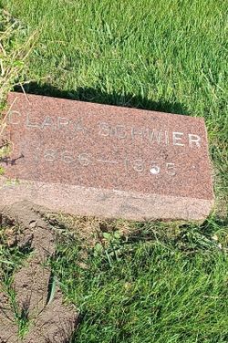
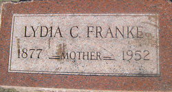
Clara M Siege Schwier
| Birth | : | 9 Mar 1866 Dubuque, Dubuque County, Iowa, USA |
| Death | : | 3 Oct 1955 Sioux City, Woodbury County, Iowa, USA |
| Burial | : | All Saints Churchyard, Semer, Babergh District, England |
| Coordinate | : | 52.0833230, 0.9161770 |
frequently asked questions (FAQ):
-
Where is Clara M Siege Schwier's memorial?
Clara M Siege Schwier's memorial is located at: All Saints Churchyard, Semer, Babergh District, England.
-
When did Clara M Siege Schwier death?
Clara M Siege Schwier death on 3 Oct 1955 in Sioux City, Woodbury County, Iowa, USA
-
Where are the coordinates of the Clara M Siege Schwier's memorial?
Latitude: 52.0833230
Longitude: 0.9161770
Family Members:
Parent
Spouse

Siblings
Children
Flowers:


Nearby Cemetories:
1. All Saints Churchyard
Semer, Babergh District, England
Coordinate: 52.0833230, 0.9161770
2. St Mary Churchyard
Nedging, Babergh District, England
Coordinate: 52.0961240, 0.9162650
3. All Saints Churchyard
Chelsworth, Babergh District, England
Coordinate: 52.0941820, 0.8896270
4. St. Margaret's Churchyard
Whatfield, Babergh District, England
Coordinate: 52.0809720, 0.9541610
5. St Mary Magdelene
Bildeston, Babergh District, England
Coordinate: 52.1056020, 0.8982980
6. St Peter's Churchyard
Lindsey, Babergh District, England
Coordinate: 52.0672960, 0.8842620
7. St. Mary's Churchyard
Kersey, Babergh District, England
Coordinate: 52.0574611, 0.9190082
8. St. Mary's Churchyard
Naughton, Babergh District, England
Coordinate: 52.1019900, 0.9519300
9. Saint Peter's Churchyard
Monks Eleigh, Babergh District, England
Coordinate: 52.0930860, 0.8688960
10. Monks Eleigh United Reformed Church
Monks Eleigh, Babergh District, England
Coordinate: 52.0918390, 0.8673530
11. St Peter's Churchyard
Milden, Babergh District, England
Coordinate: 52.0824970, 0.8569200
12. Friars Road Cemetery
Hadleigh, Babergh District, England
Coordinate: 52.0481800, 0.9453100
13. All Saints Churchyard
Hitcham, Babergh District, England
Coordinate: 52.1226340, 0.8974440
14. St Nicholas Churchyard
Wattisham, Babergh District, England
Coordinate: 52.1241910, 0.9344540
15. St. Mary's Churchyard
Aldham, Babergh District, England
Coordinate: 52.0604960, 0.9756480
16. St Mary Churchyard
Kettlebaston, Babergh District, England
Coordinate: 52.1158580, 0.8698780
17. St. Mary's Churchyard
Hadleigh, Babergh District, England
Coordinate: 52.0436290, 0.9526880
18. Hadleigh Baptist Churchyard
Hadleigh, Babergh District, England
Coordinate: 52.0444510, 0.9562658
19. Hadleigh United Reformed Churchyard
Hadleigh, Babergh District, England
Coordinate: 52.0426790, 0.9533380
20. Wattisham Baptist Chapelyard
Wattisham, Babergh District, England
Coordinate: 52.1295550, 0.9353850
21. St. Mary & St. Lawrence Churchyard
Great Bricett, Mid Suffolk District, England
Coordinate: 52.1167140, 0.9762430
22. St Mary Churchyard
Brent Eleigh, Babergh District, England
Coordinate: 52.0983910, 0.8341560
23. St. Peter's Churchyard
Elmsett, Babergh District, England
Coordinate: 52.0849030, 1.0036590
24. St Mary's Churchyard
Preston St Mary, Babergh District, England
Coordinate: 52.1166280, 0.8410180