

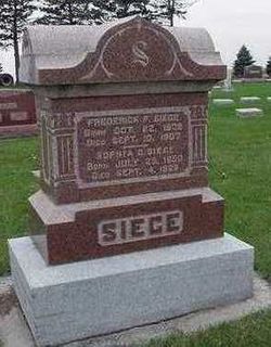
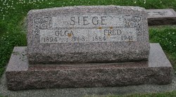
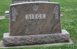
Henry Frederic “Fred” Siege
| Birth | : | 13 Dec 1884 Stanwood, Cedar County, Iowa, USA |
| Death | : | 29 Nov 1941 Maurice, Sioux County, Iowa, USA |
| Burial | : | Burnley Cemetery, Burnley, Burnley Borough, England |
| Coordinate | : | 53.7821730, -2.2795070 |
frequently asked questions (FAQ):
-
Where is Henry Frederic “Fred” Siege's memorial?
Henry Frederic “Fred” Siege's memorial is located at: Burnley Cemetery, Burnley, Burnley Borough, England.
-
When did Henry Frederic “Fred” Siege death?
Henry Frederic “Fred” Siege death on 29 Nov 1941 in Maurice, Sioux County, Iowa, USA
-
Where are the coordinates of the Henry Frederic “Fred” Siege's memorial?
Latitude: 53.7821730
Longitude: -2.2795070
Family Members:
Parent

Spouse
Siblings

Children

Flowers:


Nearby Cemetories:
1. Burnley Cemetery
Burnley, Burnley Borough, England
Coordinate: 53.7821730, -2.2795070
2. Burnley Crematorium
Burnley, Burnley Borough, England
Coordinate: 53.7821730, -2.2795070
3. Holy Trinity Churchyard
Burnley, Burnley Borough, England
Coordinate: 53.7898290, -2.2574200
4. All Saints Churchyard
Habergham Eaves, Burnley Borough, England
Coordinate: 53.7971060, -2.2913770
5. St. James' Churchyard
Burnley, Burnley Borough, England
Coordinate: 53.7905590, -2.2458280
6. St Margaret Churchyard
Hapton, Burnley Borough, England
Coordinate: 53.7802400, -2.3169230
7. St. John's Cemetery
Padiham, Burnley Borough, England
Coordinate: 53.7948720, -2.3145290
8. St. Peter's Churchyard
Burnley, Burnley Borough, England
Coordinate: 53.7924450, -2.2394890
9. Ebenezer Baptist Chapel Chapelyard
Burnley, Burnley Borough, England
Coordinate: 53.7975120, -2.2397260
10. St. Leonard's Churchyard
Padiham, Burnley Borough, England
Coordinate: 53.8022600, -2.3164300
11. Wesleyan Methodist Chapel Chapelyard
Padiham, Burnley Borough, England
Coordinate: 53.8018980, -2.3181730
12. St Leonard Churchyard Extension
Padiham, Burnley Borough, England
Coordinate: 53.7991800, -2.3222000
13. Providence Free United Methodist Graveyard
Crawshawbooth, Rossendale Borough, England
Coordinate: 53.7442070, -2.2825700
14. St James Church
Altham, Hyndburn Borough, England
Coordinate: 53.7928940, -2.3465250
15. St John Churchyard
Higham, Pendle Borough, England
Coordinate: 53.8251420, -2.2898120
16. Accrington Cemetery and Crematorium
Accrington, Hyndburn Borough, England
Coordinate: 53.7623787, -2.3508649
17. Rehoboth Chapel
Goodshaw, Rossendale Borough, England
Coordinate: 53.7355870, -2.2914730
18. St. Anne Churchyard
Fence, Pendle Borough, England
Coordinate: 53.8304372, -2.2679552
19. Goodshaw Particular Baptist Chapel Graveyard
Goodshaw, Rossendale Borough, England
Coordinate: 53.7328210, -2.2815530
20. St. Mary and All Saints Churchyard
Goodshaw, Rossendale Borough, England
Coordinate: 53.7315270, -2.2828940
21. Wheatley Lane Methodist Churchyard
Fence, Pendle Borough, England
Coordinate: 53.8341457, -2.2596202
22. St. James' Churchyard
Briercliffe, Burnley Borough, England
Coordinate: 53.8107700, -2.2031800
23. St. John's Churchyard
Read, Ribble Valley Borough, England
Coordinate: 53.8088800, -2.3585600
24. St Marys Burial Ground
Clayton-le-Moors, Hyndburn Borough, England
Coordinate: 53.7792778, -2.3705871