
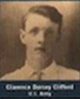
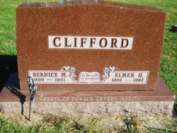
Clarence Dorsey Clifford
| Birth | : | 11 Nov 1894 Carroll County, Iowa, USA |
| Death | : | 22 Oct 1918 Fort Riley, Geary County, Kansas, USA |
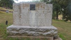
| Burial | : | Coon Rapids Cemetery, Coon Rapids, Carroll County, USA |
| Coordinate | : | 41.8778000, -94.6678009 |
| Inscription | : | 15TH CO. 164th D. B. (15th Company, 164th Depot Brigade) |
| Description | : | Obituary courtesy of Contributor #49347840 COON RAPIDS ENTERPRISE October 25, 1918 Clarence D. Clifford, son of Mr. and Mrs. C. D. Clifford, died Tuesday, October 22, at the base hospital, Fort Riley, Kansas, from pneumonia which resulted from measles. He was taken sick at Camp Funston, Kansas, about three weeks ago and was soon removed to the military hospital at Ft. Riley. The deceased's wife and parents went to his bedside immediately upon receiving word that he was sick. Mr. Clifford returning last Saturday, the wife and mother remaining. Mr. Clifford was starting on his... Read More |
frequently asked questions (FAQ):
-
Where is Clarence Dorsey Clifford's memorial?
Clarence Dorsey Clifford's memorial is located at: Coon Rapids Cemetery, Coon Rapids, Carroll County, USA.
-
When did Clarence Dorsey Clifford death?
Clarence Dorsey Clifford death on 22 Oct 1918 in Fort Riley, Geary County, Kansas, USA
-
Where are the coordinates of the Clarence Dorsey Clifford's memorial?
Latitude: 41.8778000
Longitude: -94.6678009
Family Members:
Parent
Spouse
Siblings

Flowers:


Nearby Cemetories:
1. Union Township Cemetery
Coon Rapids, Carroll County, USA
Coordinate: 41.8781013, -94.6389008
2. Oak Hill Cemetery
Coon Rapids, Carroll County, USA
Coordinate: 41.9053001, -94.7200012
3. Orange Township Cemetery
Guthrie County, USA
Coordinate: 41.8163986, -94.6844025
4. Old Carrollton Cemetery
Carrollton, Carroll County, USA
Coordinate: 41.9233017, -94.7403030
5. Willow Cemetery
Greene County, USA
Coordinate: 41.9067001, -94.5730972
6. Tuttles Grove Cemetery
Guthrie County, USA
Coordinate: 41.8130989, -94.7228012
7. Highland Cemetery
Bayard, Guthrie County, USA
Coordinate: 41.8241997, -94.5717010
8. McCurdy Cemetery
Carroll County, USA
Coordinate: 41.9403000, -94.7649994
9. Viola Center Cemetery
Viola Center, Audubon County, USA
Coordinate: 41.8236008, -94.8016968
10. Saint Josephs Cemetery
Dedham, Carroll County, USA
Coordinate: 41.8993988, -94.8210983
11. Dedham Cemetery
Dedham, Carroll County, USA
Coordinate: 41.8993988, -94.8225021
12. Union Township Cemetery
Guthrie County, USA
Coordinate: 41.7391450, -94.6858030
13. Seeley Township Cemetery
Guthrie County, USA
Coordinate: 41.7318993, -94.6147003
14. Saint Marys Catholic Cemetery
Willey, Carroll County, USA
Coordinate: 41.9783363, -94.8212204
15. Dodge Center Cemetery
Bagley, Guthrie County, USA
Coordinate: 41.8194008, -94.4697037
16. Scranton Township Cemetery
Scranton, Greene County, USA
Coordinate: 42.0306015, -94.5783005
17. Melville Township Cemetery
Audubon County, USA
Coordinate: 41.7439003, -94.8013992
18. Elba Cemetery
Templeton, Carroll County, USA
Coordinate: 41.9068985, -94.9131012
19. Greenbrier Cemetery
Cooper, Greene County, USA
Coordinate: 41.9063988, -94.4218979
20. Luccocks Grove Cemetery
Audubon County, USA
Coordinate: 41.7619019, -94.8653030
21. Cameron Cemetery
Audubon County, USA
Coordinate: 41.8236008, -94.9167023
22. Moffit Grove Cemetery
Yale, Guthrie County, USA
Coordinate: 41.7668991, -94.4539032
23. West Lawn Cemetery
Glidden, Carroll County, USA
Coordinate: 42.0649986, -94.7406006
24. Dillavou Cemetery
Kendrick Township, Greene County, USA
Coordinate: 42.0802994, -94.6138992