
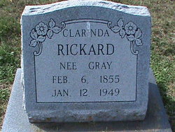
Clarinda Gray Newberger
| Birth | : | 27 Sep 1859 Missouri, USA |
| Death | : | 14 Jan 1949 Farmington, St. Francois County, Missouri, USA |
| Burial | : | Beaver Run Cemetery, Burlington, Mineral County, USA |
| Coordinate | : | 39.3467712, -78.8677979 |
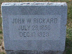
| Description | : | First Husband: John Wesley Rickard Second Husband: Adam Newberger Daughter of Henry & Clarinda Gray |
frequently asked questions (FAQ):
-
Where is Clarinda Gray Newberger's memorial?
Clarinda Gray Newberger's memorial is located at: Beaver Run Cemetery, Burlington, Mineral County, USA.
-
When did Clarinda Gray Newberger death?
Clarinda Gray Newberger death on 14 Jan 1949 in Farmington, St. Francois County, Missouri, USA
-
Where are the coordinates of the Clarinda Gray Newberger's memorial?
Latitude: 39.3467712
Longitude: -78.8677979
Family Members:
Spouse
Children


Nearby Cemetories:
1. Beaver Run Cemetery
Burlington, Mineral County, USA
Coordinate: 39.3467712, -78.8677979
2. Shoemaker Cemetery
Burlington, Mineral County, USA
Coordinate: 39.3288260, -78.8835580
3. Arnold Cemetery
Junction, Hampshire County, USA
Coordinate: 39.3235900, -78.8751500
4. Nicholas Leatherman Cemetery
Burlington, Mineral County, USA
Coordinate: 39.3625720, -78.8912770
5. Sloan - Ludwick Cemetery
Junction, Hampshire County, USA
Coordinate: 39.3143500, -78.8479500
6. Parker Family Cemetery
Mechanicsburg, Hampshire County, USA
Coordinate: 39.3273390, -78.8230560
7. Burlington Cemetery
Burlington, Mineral County, USA
Coordinate: 39.3356780, -78.9204500
8. Parker Cemetery
Junction, Hampshire County, USA
Coordinate: 39.3168360, -78.8258110
9. Headsville Methodist Episcopal Church Cemetery
Keyser, Mineral County, USA
Coordinate: 39.3899078, -78.8533401
10. Thrush Cemetery #01
Burlington, Mineral County, USA
Coordinate: 39.3588200, -78.9289400
11. John High Cemetery
Junction, Hampshire County, USA
Coordinate: 39.2938140, -78.8832230
12. Elijah High Cemetery
Purgitsville, Hampshire County, USA
Coordinate: 39.2882996, -78.8921967
13. Greenwall Cemetery
Headsville, Mineral County, USA
Coordinate: 39.4077230, -78.8491330
14. Mount Olive United Methodist Church Cemetery
Purgitsville, Hampshire County, USA
Coordinate: 39.2871260, -78.8970630
15. Sears Cemetery
Mineral County, USA
Coordinate: 39.4026900, -78.9148200
16. Sloan Cemetery
Burlington, Mineral County, USA
Coordinate: 39.3091380, -78.9401280
17. Bane Cemetery
Burlington, Mineral County, USA
Coordinate: 39.3579200, -78.9598200
18. Herriott Family Cemetery
Romney, Hampshire County, USA
Coordinate: 39.3765550, -78.7826250
19. Indian Mound Cemetery
Romney, Hampshire County, USA
Coordinate: 39.3432999, -78.7660980
20. Mount Pisgah Benevolent Cemetery
Romney, Hampshire County, USA
Coordinate: 39.3418800, -78.7661500
21. Orr Cemetery
Independence, Preston County, USA
Coordinate: 39.4252620, -78.8777500
22. Old Stone Chapel Cemetery
Mineral County, USA
Coordinate: 39.3404300, -78.9731200
23. Agnew Family Cemetery
Rada, Hampshire County, USA
Coordinate: 39.2738350, -78.9234480
24. Cabin Run Cemetery
Keyser, Mineral County, USA
Coordinate: 39.4206009, -78.9216995