

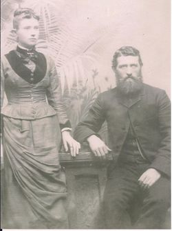
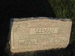
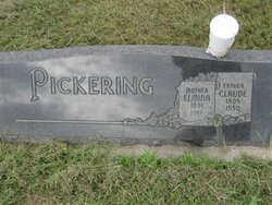
Clarissa O. “Clara” Stoner Seeman
| Birth | : | 23 Feb 1897 Unadilla, Otoe County, Nebraska, USA |
| Death | : | 7 Mar 1974 Palmyra, Otoe County, Nebraska, USA |
| Burial | : | Easton Cemetery, Easton, Leavenworth County, USA |
| Coordinate | : | 39.3395882, -95.1237793 |
frequently asked questions (FAQ):
-
Where is Clarissa O. “Clara” Stoner Seeman's memorial?
Clarissa O. “Clara” Stoner Seeman's memorial is located at: Easton Cemetery, Easton, Leavenworth County, USA.
-
When did Clarissa O. “Clara” Stoner Seeman death?
Clarissa O. “Clara” Stoner Seeman death on 7 Mar 1974 in Palmyra, Otoe County, Nebraska, USA
-
Where are the coordinates of the Clarissa O. “Clara” Stoner Seeman's memorial?
Latitude: 39.3395882
Longitude: -95.1237793
Family Members:
Parent

Spouse
Siblings

Flowers:


Nearby Cemetories:
1. Easton Cemetery
Easton, Leavenworth County, USA
Coordinate: 39.3395882, -95.1237793
2. Saint Lawrence Cemetery
Easton, Leavenworth County, USA
Coordinate: 39.3443985, -95.1335983
3. Stranger Creek Cemetery
Easton, Leavenworth County, USA
Coordinate: 39.3211100, -95.1016700
4. Langley Cemetery
Easton, Leavenworth County, USA
Coordinate: 39.3616982, -95.1611023
5. Evergreen Cemetery
Millwood, Leavenworth County, USA
Coordinate: 39.3833008, -95.1333008
6. Sparks Cemetery
Easton, Leavenworth County, USA
Coordinate: 39.2958336, -95.1355591
7. Oak Hill Cemetery
Millwood, Leavenworth County, USA
Coordinate: 39.3833008, -95.0943985
8. Mount Olivet Cemetery
Easton, Leavenworth County, USA
Coordinate: 39.3385010, -95.0582962
9. Mary Ackley Gravesite
Leavenworth County, USA
Coordinate: 39.3317300, -95.0402100
10. Bethel Cemetery
Springdale, Leavenworth County, USA
Coordinate: 39.2846985, -95.0777969
11. Saint Johns Lutheran Cemetery
Millwood, Leavenworth County, USA
Coordinate: 39.4042015, -95.1386032
12. Springdale Cemetery
Springdale, Leavenworth County, USA
Coordinate: 39.2672200, -95.1413900
13. Pleasant Ridge Cemetery
Lowemont, Leavenworth County, USA
Coordinate: 39.3792000, -95.0344009
14. Saint Thomas Cemetery
Springdale, Leavenworth County, USA
Coordinate: 39.2597008, -95.1192017
15. Round Prairie Cemetery
Lowemont, Leavenworth County, USA
Coordinate: 39.4122009, -95.0738983
16. Friends Church Cemetery
Springdale, Leavenworth County, USA
Coordinate: 39.2532800, -95.1237100
17. Fairview Cemetery
Potter, Atchison County, USA
Coordinate: 39.4239006, -95.1613998
18. Hull Grove Cemetery
Winchester, Jefferson County, USA
Coordinate: 39.3630981, -95.2435989
19. Wise Cemetery
Winchester, Jefferson County, USA
Coordinate: 39.3107986, -95.2485962
20. Hays Cemetery
Oak Mills, Atchison County, USA
Coordinate: 39.4370300, -95.0883700
21. Corpus Christi Cemetery
Winchester, Jefferson County, USA
Coordinate: 39.3908005, -95.2394028
22. High Prairie Cemetery
Leavenworth County, USA
Coordinate: 39.2724991, -95.0168991
23. Old Young Cemetery
Potter, Atchison County, USA
Coordinate: 39.4480782, -95.1176071
24. Sacks Family Cemetery
Oak Mills, Atchison County, USA
Coordinate: 39.4216800, -95.0316000