
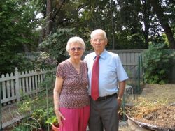
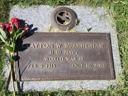
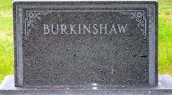
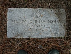
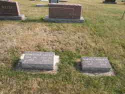
Clayton Wayne Burkinshaw
| Birth | : | 9 Feb 1915 Jamison, Keya Paha County, Nebraska, USA |
| Death | : | 16 Oct 2012 Sacramento County, California, USA |
| Burial | : | Oakmont Memorial Park, Lafayette, Contra Costa County, USA |
| Coordinate | : | 37.9475746, -122.0988770 |
| Plot | : | Inspiration Land Garden |
| Inscription | : | S1 US NAVY WORLD WAR II |
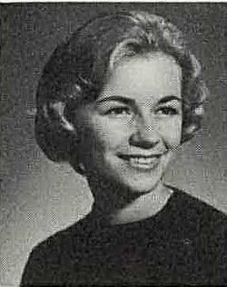
| Description | : | Wayne grew up in Nebraska and Burke, South Dakota. He attended Wayne State University before moving to San Francisco where he met the love of his life, Ruth Dingley. They married in 1940 and he served in the Navy during WWII. they raised 2 daughters in Pleasant Hill, California where they resided for 30 years. Wayne had many occupations including many years working as a milk driver. He loved traveling - they were able to visit 49 states (no Alaska). When he retired they moved to Pioneer, California where he built their home. ... Read More |
frequently asked questions (FAQ):
-
Where is Clayton Wayne Burkinshaw's memorial?
Clayton Wayne Burkinshaw's memorial is located at: Oakmont Memorial Park, Lafayette, Contra Costa County, USA.
-
When did Clayton Wayne Burkinshaw death?
Clayton Wayne Burkinshaw death on 16 Oct 2012 in Sacramento County, California, USA
-
Where are the coordinates of the Clayton Wayne Burkinshaw's memorial?
Latitude: 37.9475746
Longitude: -122.0988770
Family Members:
Parent

Siblings
Children
Flowers:


Nearby Cemetories:
1. Oakmont Memorial Park
Lafayette, Contra Costa County, USA
Coordinate: 37.9475746, -122.0988770
2. Queen of Heaven Cemetery
Lafayette, Contra Costa County, USA
Coordinate: 37.9446983, -122.1057968
3. Muir-Strentzel Hanna Cemetery
Martinez, Contra Costa County, USA
Coordinate: 37.9784393, -122.1232681
4. Lafayette Cemetery
Lafayette, Contra Costa County, USA
Coordinate: 37.8964005, -122.0986023
5. Saint Pauls Episcopal Columbarium
Walnut Creek, Contra Costa County, USA
Coordinate: 37.9014310, -122.0682560
6. Hulls Walnut Creek Chapel Columbarium
Walnut Creek, Contra Costa County, USA
Coordinate: 37.8955350, -122.0782110
7. Pacheco Cemetery and Crematory
Pacheco, Contra Costa County, USA
Coordinate: 37.9994011, -122.0729980
8. Saint Stephen's Cemetery
Concord, Contra Costa County, USA
Coordinate: 37.9625015, -122.0306015
9. Mount Diablo Unitarian Universalist Church Memoria
Walnut Creek, Contra Costa County, USA
Coordinate: 37.8993750, -122.0456600
10. Fales Cemetery - Defunct
Walnut Creek, Contra Costa County, USA
Coordinate: 37.8873232, -122.0618906
11. Saint Anselms Episcopal Church Columbarium
Lafayette, Contra Costa County, USA
Coordinate: 37.8737230, -122.0933820
12. Saint Stephens Episcopal Church Memorial Garden
Orinda, Contra Costa County, USA
Coordinate: 37.8982650, -122.1729170
13. Gan Shalom Cemetery
Contra Costa County, USA
Coordinate: 37.9528122, -122.1975098
14. Lafayette-Orinda Presbyterian Church Garden
Contra Costa County, USA
Coordinate: 37.8866040, -122.1606950
15. Memory Gardens Cemetery
Concord, Contra Costa County, USA
Coordinate: 38.0093994, -122.0381012
16. Saint Catherine of Siena Cemetery
Martinez, Contra Costa County, USA
Coordinate: 38.0172005, -122.1446991
17. Alhambra Cemetery
Martinez, Contra Costa County, USA
Coordinate: 38.0182991, -122.1442032
18. Live Oak Cemetery
Concord, Contra Costa County, USA
Coordinate: 37.9491997, -121.9725037
19. Benicia Army Cemetery
Benicia, Solano County, USA
Coordinate: 38.0510820, -122.1419030
20. Saint Dominics Catholic Cemetery
Benicia, Solano County, USA
Coordinate: 38.0583730, -122.1402900
21. Benicia City Cemetery
Benicia, Solano County, USA
Coordinate: 38.0576610, -122.1535930
22. Port Chicago Naval Magazine National Memorial
Concord, Contra Costa County, USA
Coordinate: 38.0574610, -122.0296950
23. Alamo Cemetery
Alamo, Contra Costa County, USA
Coordinate: 37.8361015, -122.0149994
24. Glen Cove Sacred Indian Burial Grounds
Vallejo, Solano County, USA
Coordinate: 38.0680620, -122.2064640