
| Memorials | : | 1 |
| Location | : | Contra Costa County, USA |
| Coordinate | : | 37.8866040, -122.1606950 |
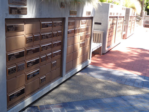
| Description | : | Kurth Memorial Garden |
frequently asked questions (FAQ):
-
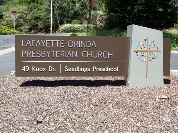
Where is Lafayette-Orinda Presbyterian Church Garden?
Lafayette-Orinda Presbyterian Church Garden is located at 49 Knox DriveLafayette, CA Contra Costa County ,California , 94549USA.
-
Lafayette-Orinda Presbyterian Church Garden cemetery's updated grave count on graveviews.com?
1 memorials
-
Where are the coordinates of the Lafayette-Orinda Presbyterian Church Garden?
Latitude: 37.8866040
Longitude: -122.1606950

Nearby Cemetories:
1. Saint Stephens Episcopal Church Memorial Garden
Orinda, Contra Costa County, USA
Coordinate: 37.8982650, -122.1729170
2. Lafayette Cemetery
Lafayette, Contra Costa County, USA
Coordinate: 37.8964005, -122.0986023
3. Saint Anselms Episcopal Church Columbarium
Lafayette, Contra Costa County, USA
Coordinate: 37.8737230, -122.0933820
4. Hulls Walnut Creek Chapel Columbarium
Walnut Creek, Contra Costa County, USA
Coordinate: 37.8955350, -122.0782110
5. Gan Shalom Cemetery
Contra Costa County, USA
Coordinate: 37.9528122, -122.1975098
6. Queen of Heaven Cemetery
Lafayette, Contra Costa County, USA
Coordinate: 37.9446983, -122.1057968
7. Saint Pauls Episcopal Columbarium
Walnut Creek, Contra Costa County, USA
Coordinate: 37.9014310, -122.0682560
8. Fales Cemetery - Defunct
Walnut Creek, Contra Costa County, USA
Coordinate: 37.8873232, -122.0618906
9. Oakmont Memorial Park
Lafayette, Contra Costa County, USA
Coordinate: 37.9475746, -122.0988770
10. Mountain View Cemetery
Oakland, Alameda County, USA
Coordinate: 37.8327600, -122.2395200
11. Saint Mary's Cemetery
Oakland, Alameda County, USA
Coordinate: 37.8349991, -122.2418976
12. Home of Eternity Cemetery
Oakland, Alameda County, USA
Coordinate: 37.8322970, -122.2448270
13. Chapel of the Chimes Columbarium and Mausoleum
Oakland, Alameda County, USA
Coordinate: 37.8318863, -122.2456894
14. Chapel of Memories Columbarium
Oakland, Alameda County, USA
Coordinate: 37.8310471, -122.2480927
15. Northbrae Community Church Columbarium
Berkeley, Alameda County, USA
Coordinate: 37.8905500, -122.2763200
16. Mount Diablo Unitarian Universalist Church Memoria
Walnut Creek, Contra Costa County, USA
Coordinate: 37.8993750, -122.0456600
17. Muir-Strentzel Hanna Cemetery
Martinez, Contra Costa County, USA
Coordinate: 37.9784393, -122.1232681
18. Saint Paul Lutheran Church
Oakland, Alameda County, USA
Coordinate: 37.8020820, -122.2222780
19. Golden Gate Mausoleum and Columbaria
El Cerrito, Contra Costa County, USA
Coordinate: 37.9073150, -122.2857220
20. Sunset View Cemetery
El Cerrito, Contra Costa County, USA
Coordinate: 37.9077721, -122.2871017
21. Sunnyside Cemetery
Oakland, Alameda County, USA
Coordinate: 37.7806260, -122.1822410
22. Cathedral of Christ the Light Mausoleum
Oakland, Alameda County, USA
Coordinate: 37.8105316, -122.2633896
23. Home of Peace Cemetery
Oakland, Alameda County, USA
Coordinate: 37.7790604, -122.2036285
24. Evergreen Cemetery
Oakland, Alameda County, USA
Coordinate: 37.7719002, -122.1782990