
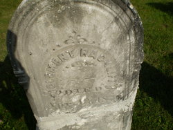
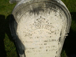
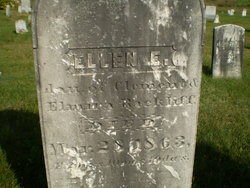
Clement Rackliff
| Birth | : | 5 Apr 1799 |
| Death | : | 12 Apr 1876 |
| Burial | : | Valley Chapel Cemetery, Canton, Stark County, USA |
| Coordinate | : | 40.8047218, -81.3202744 |
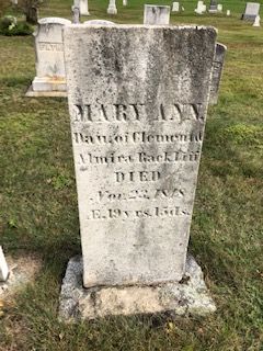
| Description | : | died at age 77y 7d Husband of Elmira. 1850 Knox Census Children: Mary Ann born abt 1829, Ellen E abt 1842, Francis abt 1845, Nelson abt 1847. Parent links added by Lori Lee Crawford Corey, 24 Dec 2021. |
frequently asked questions (FAQ):
-
Where is Clement Rackliff's memorial?
Clement Rackliff's memorial is located at: Valley Chapel Cemetery, Canton, Stark County, USA.
-
When did Clement Rackliff death?
Clement Rackliff death on 12 Apr 1876 in
-
Where are the coordinates of the Clement Rackliff's memorial?
Latitude: 40.8047218
Longitude: -81.3202744
Family Members:
Parent

Spouse
Siblings
Children
Flowers:


Nearby Cemetories:
1. Valley Chapel Cemetery
Canton, Stark County, USA
Coordinate: 40.8047218, -81.3202744
2. Evergreen Memorial Gardens
Louisville, Stark County, USA
Coordinate: 40.8156013, -81.2977982
3. Rowland Cemetery
Canton, Stark County, USA
Coordinate: 40.7930984, -81.3533020
4. Fairhope Cemetery
East Canton, Stark County, USA
Coordinate: 40.8289500, -81.2984400
5. Kountze Memorial Cemetery
Canton, Stark County, USA
Coordinate: 40.7847800, -81.2870500
6. Union Cemetery
East Canton, Stark County, USA
Coordinate: 40.7839088, -81.2878036
7. Center Church of the Brethren Cemetery
Louisville, Stark County, USA
Coordinate: 40.8147011, -81.2794037
8. Mount Tabor Methodist Church Cemetery
East Canton, Stark County, USA
Coordinate: 40.7848015, -81.2829971
9. Boyer Cemetery
Louisville, Stark County, USA
Coordinate: 40.8156930, -81.2704180
10. Brenizer Cemetery
East Canton, Stark County, USA
Coordinate: 40.7750610, -81.2835760
11. Mount Pleasant Cemetery
Canton, Stark County, USA
Coordinate: 40.8460007, -81.3180008
12. Saint Louis Cemetery
Louisville, Stark County, USA
Coordinate: 40.8241692, -81.2676773
13. Plum Street Cemetery
Canton, Stark County, USA
Coordinate: 40.7961380, -81.3798090
14. Saint Peters Cemetery
Canton, Stark County, USA
Coordinate: 40.8205986, -81.3796997
15. Canton Hebrew Cemetery
Canton, Stark County, USA
Coordinate: 40.7722015, -81.3716965
16. Saint Johns Cemetery
Canton, Stark County, USA
Coordinate: 40.8199997, -81.3846970
17. Sancta Clara Monastery Cemetery
Canton, Stark County, USA
Coordinate: 40.8450430, -81.3642880
18. Stark County Infirmary Cemetery (Defunct)
Plain Township, Stark County, USA
Coordinate: 40.8283450, -81.3859340
19. McKinley Memorial Park
Canton, Stark County, USA
Coordinate: 40.8073600, -81.3931910
20. Henry Warstler Cemetery
Plain Township, Stark County, USA
Coordinate: 40.8600006, -81.3332977
21. West Lawn Cemetery
Canton, Stark County, USA
Coordinate: 40.8046640, -81.3948940
22. Merith Farm Cemetery
Mapleton, Stark County, USA
Coordinate: 40.7553030, -81.2729930
23. Saint Marks Episcopal Church Columbarium
Canton, Stark County, USA
Coordinate: 40.8524920, -81.3729960
24. Mount Zion Cemetery
Canton, Stark County, USA
Coordinate: 40.7419879, -81.3415546