
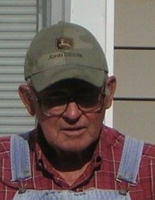
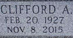

Clifford Andrew Spitser
| Birth | : | 20 Feb 1927 Pawnee City, Pawnee County, Nebraska, USA |
| Death | : | 8 Nov 2015 Pawnee City, Pawnee County, Nebraska, USA |
| Burial | : | Pawnee City Cemetery, Pawnee City, Pawnee County, USA |
| Coordinate | : | 40.1109009, -96.1608810 |
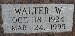
| Description | : | Clifford is the son of Elmer and Ida (Snyder) Spister. Clifford married Betty. They are the parents of Kevin Lee & Larry. Clifford Andrew Spitser of Pawnee City, NE was born February 20, 1927 at Pawnee City to Elmer Clay and Ida Frances (Snyder) Spitser. He passed away November 8, 2015. Cliff attended schools in both Pawnee and Richardson counties; graduating in 1944 at Shubert, NE. After graduation he and his brother, Walter, farmed together for over 50 years in both Richardson and Pawnee counties. On May 20, 1951 Clifford married Betty McKinsey at the Christian Church in Verdon, Nebraska. In 1957 they moved... Read More |
frequently asked questions (FAQ):
-
Where is Clifford Andrew Spitser's memorial?
Clifford Andrew Spitser's memorial is located at: Pawnee City Cemetery, Pawnee City, Pawnee County, USA.
-
When did Clifford Andrew Spitser death?
Clifford Andrew Spitser death on 8 Nov 2015 in Pawnee City, Pawnee County, Nebraska, USA
-
Where are the coordinates of the Clifford Andrew Spitser's memorial?
Latitude: 40.1109009
Longitude: -96.1608810
Family Members:
Parent

Siblings


Children
Flowers:


Nearby Cemetories:
1. Pawnee City Cemetery
Pawnee City, Pawnee County, USA
Coordinate: 40.1109009, -96.1608810
2. East Amish Cemetery
Table Rock, Pawnee County, USA
Coordinate: 40.1310000, -96.0854000
3. Evergreen Cemetery
Pawnee County, USA
Coordinate: 40.0485992, -96.1417007
4. Pleasant Valley Cemetery
Pawnee County, USA
Coordinate: 40.0299988, -96.1554794
5. Table Rock Cemetery
Table Rock, Pawnee County, USA
Coordinate: 40.1791400, -96.1037400
6. Prairie Star Pioneer Cemetery
Du Bois, Pawnee County, USA
Coordinate: 40.0293000, -96.1041000
7. Beranek Cemetery
Table Rock, Pawnee County, USA
Coordinate: 40.2042007, -96.1607971
8. Pleasant Ridge Cemetery
Du Bois, Pawnee County, USA
Coordinate: 40.0156000, -96.1494000
9. West Branch Cemetery
Pawnee County, USA
Coordinate: 40.0787940, -96.2797160
10. Saint Anthonys Cemetery
Steinauer, Pawnee County, USA
Coordinate: 40.2075005, -96.2189026
11. Johnson Creek Cemetery
Pawnee City, Pawnee County, USA
Coordinate: 40.0270000, -96.2465000
12. Clear Creek Cemetery
Table Rock, Pawnee County, USA
Coordinate: 40.2193985, -96.1391983
13. Bohemian Cemetery
Table Rock, Pawnee County, USA
Coordinate: 40.1786003, -96.0374985
14. Saint Peters Evangelican Cemetery
Du Bois, Pawnee County, USA
Coordinate: 40.0010000, -96.1095000
15. Dry Branch Pioneer Cemetery
Richardson County, USA
Coordinate: 40.1292000, -96.0100021
16. DuBois Cemetery
Du Bois, Pawnee County, USA
Coordinate: 40.0231018, -96.0488968
17. Bohemian Cemetery
Richardson County, USA
Coordinate: 40.1175003, -95.9955978
18. Saint Johns Cemetery
Table Rock, Pawnee County, USA
Coordinate: 40.2148000, -96.0657000
19. Salems Cemetery
Steinauer, Pawnee County, USA
Coordinate: 40.2166000, -96.2555000
20. McCaffrey Cemetery
Nemaha County, USA
Coordinate: 39.9827100, -96.1474500
21. Madden Cemetery
Axtell, Marshall County, USA
Coordinate: 39.9866800, -96.2490300
22. Friedens United Church of Christ Cemetery
Bern, Nemaha County, USA
Coordinate: 39.9929008, -96.0529480
23. Saint Peters Lutheran Church Cemetery
Steinauer, Pawnee County, USA
Coordinate: 40.2555000, -96.1801000
24. Cincinnati Cemetery
Du Bois, Pawnee County, USA
Coordinate: 40.0042000, -96.0274963