
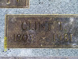
Clint Akin
| Birth | : | 1903 |
| Death | : | 1981 |
| Burial | : | Yoder Cemetery, Arthur, Douglas County, USA |
| Coordinate | : | 39.6608009, -88.4477997 |
| Description | : | Clint Akin third child of John Porter and Cynthia A. Moon Akin was born in Akinsville, Missouri. Clint farmed and married Gladys Drummond Madole. To this union one daughter was born, Carol Jean. Carol taught school and married Woodson Moore. They have one daughter born in 1972, Cindy Jane. They reside in Gladstone, Missouri. |
frequently asked questions (FAQ):
-
Where is Clint Akin's memorial?
Clint Akin's memorial is located at: Yoder Cemetery, Arthur, Douglas County, USA.
-
When did Clint Akin death?
Clint Akin death on 1981 in
-
Where are the coordinates of the Clint Akin's memorial?
Latitude: 39.6608009
Longitude: -88.4477997
Family Members:
Parent
Spouse

Siblings


Nearby Cemetories:
1. Yoder Cemetery
Arthur, Douglas County, USA
Coordinate: 39.6608009, -88.4477997
2. Trinity Christian Fellowship Cemetery
Sullivan, Moultrie County, USA
Coordinate: 39.6666990, -88.4761040
3. Pleasant View Church Cemetery
Chesterville, Douglas County, USA
Coordinate: 39.6732292, -88.4136581
4. Miller Cemetery
Chesterville, Douglas County, USA
Coordinate: 39.7032242, -88.4142761
5. Bagdad School Cemetery
Arcola, Douglas County, USA
Coordinate: 39.6796500, -88.3872800
6. Yoder Cemetery
Arthur, Douglas County, USA
Coordinate: 39.7105293, -88.4577026
7. Arthur Cemetery
Arthur, Douglas County, USA
Coordinate: 39.7151909, -88.4610901
8. Bagdad Cemetery
Douglas County, USA
Coordinate: 39.6821000, -88.3724000
9. Seass Cemetery
Moultrie County, USA
Coordinate: 39.6444016, -88.5289001
10. Sunnyside Mennonite Church Cemetery
Douglas County, USA
Coordinate: 39.7009000, -88.3811000
11. Chesterville Cemetery
Chesterville, Douglas County, USA
Coordinate: 39.7060000, -88.3865000
12. Brann Cemetery
North Okaw Township, Coles County, USA
Coordinate: 39.6403008, -88.3628006
13. Filmore Cemetery
Chesterville, Douglas County, USA
Coordinate: 39.7177000, -88.3910000
14. Gingerich Cemetery
Sullivan, Moultrie County, USA
Coordinate: 39.6797830, -88.5381920
15. Gardner Cemetery
Humboldt Township, Coles County, USA
Coordinate: 39.6514015, -88.3531036
16. Bolin Cemetery
Moultrie County, USA
Coordinate: 39.6116982, -88.5263977
17. Pleasant Grove Cemetery
North Okaw Township, Coles County, USA
Coordinate: 39.5859299, -88.4144135
18. Jonathan Creek Cemetery
Sullivan, Moultrie County, USA
Coordinate: 39.6114807, -88.5288315
19. Ginn-Ellis Cemetery
East Nelson Township, Moultrie County, USA
Coordinate: 39.5811160, -88.4644200
20. Zoar Cemetery
North Okaw Township, Coles County, USA
Coordinate: 39.5715790, -88.4436722
21. Herschberger Cemetery
Sullivan, Moultrie County, USA
Coordinate: 39.5852470, -88.5150790
22. Smith Cemetery
North Okaw Township, Coles County, USA
Coordinate: 39.5744019, -88.4000015
23. Mount Zion General Baptist Cemetery
North Okaw Township, Coles County, USA
Coordinate: 39.5672493, -88.4602890
24. Prairie Mennonite Church Cemetery
Douglas County, USA
Coordinate: 39.7550960, -88.4391840