
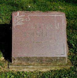
| Birth | : | 1 Dec 1917 Defiance County, Ohio, USA |
| Death | : | 17 Sep 2000 Apache Junction, Pinal County, Arizona, USA |
| Burial | : | Old Burial Ground, Rutland, Worcester County, USA |
| Coordinate | : | 42.3756000, -71.9578000 |
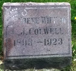
| Description | : | Clinton J. Colwell Jr., 82, Mayer, died at 7:45 a.m. Sunday, September 17, 2000, in Apache Junction Health Center, Apache Junction. He was born Dec. 1, 1917, in Defiance, the son of Clinton Sr. and Irene (Mohr) Colwell. In 1938, he married Lillian Zachrich, who died in 1998. He was a mechanic, a member of St. John Lutheran Church in Defiance and a South Richland Township Volunteer Fire Department chief from 1954-1960. Surviving are a son, Larry, Apache Junction; a brother, James, Ayersville; two sisters, Lois Tracy of Defiance and Dorothy Adair, Litchfield, Mich.; and two grandchildren and three... Read More |
frequently asked questions (FAQ):
-
Where is Clinton James Colwell Jr.'s memorial?
Clinton James Colwell Jr.'s memorial is located at: Old Burial Ground, Rutland, Worcester County, USA.
-
When did Clinton James Colwell Jr. death?
Clinton James Colwell Jr. death on 17 Sep 2000 in Apache Junction, Pinal County, Arizona, USA
-
Where are the coordinates of the Clinton James Colwell Jr.'s memorial?
Latitude: 42.3756000
Longitude: -71.9578000
Family Members:
Parent
Spouse

Siblings
Flowers:


Nearby Cemetories:
1. Old Burial Ground
Rutland, Worcester County, USA
Coordinate: 42.3756000, -71.9578000
2. Rutland Rural Cemetery
Rutland, Worcester County, USA
Coordinate: 42.3790100, -71.9447500
3. West Rutland Cemetery
Rutland, Worcester County, USA
Coordinate: 42.3561970, -71.9897170
4. Putnam Farm Cemetery
Rutland, Worcester County, USA
Coordinate: 42.3484010, -71.9771420
5. Smith Family Cemetery
Rutland, Worcester County, USA
Coordinate: 42.3946064, -71.9231169
6. Rutland Prison Camp Cemetery
Rutland, Worcester County, USA
Coordinate: 42.3988500, -71.9923800
7. Goose Hill Cemetery
Rutland, Worcester County, USA
Coordinate: 42.3997400, -71.9914000
8. Mooreland Cemetery
Paxton, Worcester County, USA
Coordinate: 42.3280800, -71.9321000
9. Green Hollow Cemetery
Oakham, Worcester County, USA
Coordinate: 42.3549995, -72.0243988
10. Worcester County Memorial Park
Paxton, Worcester County, USA
Coordinate: 42.3245697, -71.9308777
11. South Burying Ground
Princeton, Worcester County, USA
Coordinate: 42.4192009, -71.8957977
12. Oakham Center Cemetery
Oakham, Worcester County, USA
Coordinate: 42.3540000, -72.0421400
13. Paxton Center Cemetery
Paxton, Worcester County, USA
Coordinate: 42.3128900, -71.9277700
14. Parker Cemetery
Barre, Worcester County, USA
Coordinate: 42.4250800, -72.0240400
15. South Cemetery
Oakham, Worcester County, USA
Coordinate: 42.3382988, -72.0374985
16. Saint Mary Cemetery
Holden, Worcester County, USA
Coordinate: 42.3522400, -71.8684200
17. Grove Cemetery
Holden, Worcester County, USA
Coordinate: 42.3520400, -71.8672700
18. Park Avenue Cemetery
Holden, Worcester County, USA
Coordinate: 42.3514200, -71.8656900
19. Coldbrook Cemetery
Barre, Worcester County, USA
Coordinate: 42.3944016, -72.0541992
20. West Cemetery
Princeton, Worcester County, USA
Coordinate: 42.4454100, -71.9256500
21. Route 62 Cemetery
Hubbardston, Worcester County, USA
Coordinate: 42.4426910, -72.0014980
22. Old Burying Ground
Holden, Worcester County, USA
Coordinate: 42.3505800, -71.8626000
23. Saint Francis Episcopal Church Memorial Garden
Holden, Worcester County, USA
Coordinate: 42.3522800, -71.8588700
24. Southwest Cemetery
Oakham, Worcester County, USA
Coordinate: 42.3457985, -72.0582962