
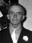
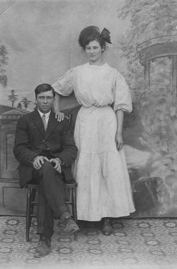

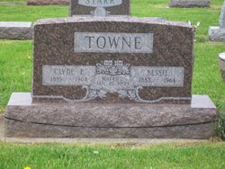
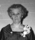
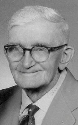
Clyde Elry Towne
| Birth | : | 11 Jun 1885 Walnut, Marshall County, Indiana, USA |
| Death | : | 26 Jan 1964 Rochester, Fulton County, Indiana, USA |
| Burial | : | South Gower Cemetery, South Gower, Leeds and Grenville United Counties, Canada |
| Coordinate | : | 45.0080338, -75.5640259 |
| Plot | : | Section 12, Row 1 |
| Description | : | Published in Rochester News-Sentinel Monday, January 27, 1964 Clyde E. Towne Clyde E. TOWNE, 78, 206 Monticello road, died at his home at 6 a.m. Sunday following an illness of 2 1/2 years. He suffered his first stroke in May, 1962. A lifetime resident of Fulton county, Mr. Towne had resided most of his life in Newcastle township. He lived on Monticello road for 1 1/2 years. Mr. Towne was born in Walnut, Ind., June 11, 1885 to Alfred and Emma RUSH TOWNE. He was married in 1908 in Rochester to Bessie HARTMAN. A retird farmer, he had been a bus driver for Talma schools... Read More |
frequently asked questions (FAQ):
-
Where is Clyde Elry Towne's memorial?
Clyde Elry Towne's memorial is located at: South Gower Cemetery, South Gower, Leeds and Grenville United Counties, Canada.
-
When did Clyde Elry Towne death?
Clyde Elry Towne death on 26 Jan 1964 in Rochester, Fulton County, Indiana, USA
-
Where are the coordinates of the Clyde Elry Towne's memorial?
Latitude: 45.0080338
Longitude: -75.5640259
Family Members:
Parent
Spouse
Siblings
Children
Flowers:


Nearby Cemetories:
1. D. Guy Farm Cemetery
Brinston, Stormont, Dundas and Glengarry United Counties, Canada
Coordinate: 45.0334000, -75.4993300
2. Kemptville Public Cemetery
Kemptville, Leeds and Grenville United Counties, Canada
Coordinate: 45.0245800, -75.6447300
3. Saint James Anglican Cemetery
Kemptville, Leeds and Grenville United Counties, Canada
Coordinate: 45.0160300, -75.6489300
4. Holy Cross Cemetery
Kemptville, Leeds and Grenville United Counties, Canada
Coordinate: 45.0131000, -75.6544000
5. South Mountain Union Cemetery
South Mountain, Stormont, Dundas and Glengarry United Counties, Canada
Coordinate: 44.9785970, -75.4610540
6. Oxford Mills Anglican Cemetery
Oxford Mills, Leeds and Grenville United Counties, Canada
Coordinate: 44.9615300, -75.6732500
7. Oxford Mills Union Cemetery
Oxford Mills, Leeds and Grenville United Counties, Canada
Coordinate: 44.9619500, -75.6738300
8. Van Camp United Church Cemetery
VanCamp, Stormont, Dundas and Glengarry United Counties, Canada
Coordinate: 45.0451460, -75.4458620
9. Reid's Mills Cemetery
Osgoode, Ottawa Municipality, Canada
Coordinate: 45.1036300, -75.5520500
10. Saint Paul's Anglican Cemetery
Becketts Landing, Ottawa Municipality, Canada
Coordinate: 45.0503560, -75.6880560
11. Patterson's Corners Presbyterian Cemetery
Pattersons Corners, Leeds and Grenville United Counties, Canada
Coordinate: 44.9276960, -75.6595480
12. Saint Peter's Anglican Cemetery
South Mountain, Stormont, Dundas and Glengarry United Counties, Canada
Coordinate: 45.0034050, -75.4145880
13. Knight's Cemetery
Inkerman, Stormont, Dundas and Glengarry United Counties, Canada
Coordinate: 45.0441300, -75.4136200
14. North Rideau Methodist Cemetery
Becketts Landing, Ottawa Municipality, Canada
Coordinate: 45.0233710, -75.7330285
15. Inkerman Wesleyan Methodist
Inkerman, Stormont, Dundas and Glengarry United Counties, Canada
Coordinate: 45.0378370, -75.3932470
16. Old Methodist Cemetery
Kemptville, Leeds and Grenville United Counties, Canada
Coordinate: 45.0117400, -75.3862800
17. Shanly Cemetery
Shanly, Leeds and Grenville United Counties, Canada
Coordinate: 44.8872500, -75.4740800
18. Bishops Mills Cemetery
Bishops Mills, Leeds and Grenville United Counties, Canada
Coordinate: 44.8908700, -75.6850700
19. Elmview Cemetery
Kars, Ottawa Municipality, Canada
Coordinate: 45.1438890, -75.6463890
20. Prescott Road Union Cemetery
Osgoode, Ottawa Municipality, Canada
Coordinate: 45.1574840, -75.5709650
21. Hanesville Cemetery New
Hainsville, Stormont, Dundas and Glengarry United Counties, Canada
Coordinate: 44.9047000, -75.4008300
22. Hanesville Cemetery Old
Hainsville, Stormont, Dundas and Glengarry United Counties, Canada
Coordinate: 44.9037000, -75.4010300
23. Rideauvale Cemetery
Kars, Ottawa Municipality, Canada
Coordinate: 45.1545944, -75.6493225
24. Holy Trinity Anglican Church Cemetery
North Gower, Ottawa Municipality, Canada
Coordinate: 45.1261110, -75.7155560