

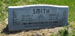
Colleen Dorothy Schmidt Smith
| Birth | : | 17 Dec 1924 Lost Nation, Clinton County, Iowa, USA |
| Death | : | 9 Aug 2009 Marion, Linn County, Iowa, USA |
| Burial | : | Wayne Cemetery, Lewis, Edwards County, USA |
| Coordinate | : | 37.9550018, -99.2144012 |
| Description | : | Colleen D. Schmidt was born December 17, 1924, in Lost Nation, Iowa, the daughter of Leon Henry and Grace Rosamond (Kammer) Schmidt. She graduated from Lost Nation High School in 1942. She married Howard Warren Smith on October 27, 1942, in Kahoka, Missouri. He died on April 22, 1998. She was a homemaker and worked at the Fish & Tackle in Maquoketa, and was head cook at the Lost Nation Community School for 10 years. She also worked the concessions at the 61 Drive Inn Theater in Maquoketa. She was a member of Bethlehem Lutheran Church, Lost Nation. She enjoyed... Read More |
frequently asked questions (FAQ):
-
Where is Colleen Dorothy Schmidt Smith's memorial?
Colleen Dorothy Schmidt Smith's memorial is located at: Wayne Cemetery, Lewis, Edwards County, USA.
-
When did Colleen Dorothy Schmidt Smith death?
Colleen Dorothy Schmidt Smith death on 9 Aug 2009 in Marion, Linn County, Iowa, USA
-
Where are the coordinates of the Colleen Dorothy Schmidt Smith's memorial?
Latitude: 37.9550018
Longitude: -99.2144012
Family Members:
Parent

Spouse

Flowers:


Nearby Cemetories:
1. Wayne Cemetery
Lewis, Edwards County, USA
Coordinate: 37.9550018, -99.2144012
2. Belpre Cemetery
Belpre, Edwards County, USA
Coordinate: 37.9528950, -99.1017510
3. Fitch Family Cemetery
Nettleton, Edwards County, USA
Coordinate: 38.0007540, -99.3256550
4. Garfield Cemetery
Garfield, Pawnee County, USA
Coordinate: 38.0738983, -99.2667007
5. Trotter Cemetery
Lewis, Edwards County, USA
Coordinate: 37.8394012, -99.2780991
6. Pleasant Valley Cemetery
Larned, Pawnee County, USA
Coordinate: 38.0718994, -99.0955963
7. Fellsburg Cemetery
Edwards County, USA
Coordinate: 37.8069000, -99.1688995
8. Peace Lutheran Cemetery
Kinsley, Edwards County, USA
Coordinate: 38.0285988, -99.4047012
9. Saint Nicholas Cemetery
Kinsley, Edwards County, USA
Coordinate: 37.9152985, -99.4235992
10. Old Kinsley Cemetery
Kinsley, Edwards County, USA
Coordinate: 37.9272003, -99.4310989
11. Hillside Cemetery
Kinsley, Edwards County, USA
Coordinate: 37.9375000, -99.4486008
12. Salem Cemetery
Edwards County, USA
Coordinate: 38.0331001, -99.4421997
13. Saint Peter and Saint Paul Cemetery
Kinsley, Edwards County, USA
Coordinate: 38.0015400, -99.4587400
14. Farmington Cemetery
Macksville, Stafford County, USA
Coordinate: 37.9574510, -98.9608270
15. Township Cemetery
Macksville, Stafford County, USA
Coordinate: 37.9569016, -98.9582977
16. Prattsburg Cemetery
Macksville, Stafford County, USA
Coordinate: 37.8283005, -99.0044022
17. Wire Family Cemetery
Kinsley, Edwards County, USA
Coordinate: 37.8430200, -99.4510100
18. Larned State Hospital Cemetery
Larned, Pawnee County, USA
Coordinate: 38.1722800, -99.1566200
19. Hopewell Cemetery
Hopewell, Pratt County, USA
Coordinate: 37.8058500, -99.0005600
20. Fort Larned Cemetery
Larned, Pawnee County, USA
Coordinate: 38.1839100, -99.2163200
21. Larned Cemetery
Larned, Pawnee County, USA
Coordinate: 38.1861000, -99.1333008
22. Providence Cemetery
Edwards County, USA
Coordinate: 37.7336006, -99.0511017
23. Bethel Cemetery
Hodges, Edwards County, USA
Coordinate: 37.7344017, -99.4131012
24. Neelands Cemetery
St. John, Stafford County, USA
Coordinate: 37.9000015, -98.8660965