
| Birth | : | 9 Jul 1810 New Castle County, Delaware, USA |
| Death | : | 21 Mar 1886 Brown County, Kansas, USA |
| Burial | : | Netawaka Cemetery, Netawaka, Jackson County, USA |
| Coordinate | : | 39.6075300, -95.7223700 |
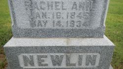
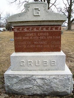
| Description | : | Collingwood, son of Joseph and Sarah Talley Grubb, was an entrepreneur who became a Kansas farmer and stationmaster on the Pony Express and Overland Stage. An ardent abolitionist, he was said to be a close friend of John Brown. In 1826, he apprenticed as a cabinet maker in Philadelphia and five years later started his own business in Media, Pennsylvania. About 1835 he married Rachel Ann Bailey and moved to Clermont, Ohio. They had two children before she died in 1837. In 1838 he married Sophia Charlotte Webb of Shelby County, Kentucky. They lived in Putnam County, Indiana,... Read More |
frequently asked questions (FAQ):
-
Where is Collingwood Clark Grubb's memorial?
Collingwood Clark Grubb's memorial is located at: Netawaka Cemetery, Netawaka, Jackson County, USA.
-
When did Collingwood Clark Grubb death?
Collingwood Clark Grubb death on 21 Mar 1886 in Brown County, Kansas, USA
-
Where are the coordinates of the Collingwood Clark Grubb's memorial?
Latitude: 39.6075300
Longitude: -95.7223700
Family Members:
Parent
Spouse

Siblings
Children
Flowers:


Nearby Cemetories:
1. Netawaka Cemetery
Netawaka, Jackson County, USA
Coordinate: 39.6075300, -95.7223700
2. Pleasant Grove Cemetery
Jackson County, USA
Coordinate: 39.5664000, -95.7789000
3. South Powhattan Cemetery
Powhattan, Brown County, USA
Coordinate: 39.6608009, -95.7596970
4. Wetmore Cemetery
Wetmore, Nemaha County, USA
Coordinate: 39.6396800, -95.8108400
5. Grant-Mjessepe Cemetery
Horton, Brown County, USA
Coordinate: 39.6663000, -95.6576000
6. Spring Hill Cemetery
Whiting, Jackson County, USA
Coordinate: 39.6021996, -95.6121979
7. Jessepe Indian Cemetery
Horton, Brown County, USA
Coordinate: 39.6715000, -95.6438000
8. Kennekuk Church Cemetery
Horton, Brown County, USA
Coordinate: 39.7074600, -95.6672300
9. Estes Cemetery
Jackson County, USA
Coordinate: 39.5346985, -95.6168976
10. Wolfley Cemetery
Goff, Nemaha County, USA
Coordinate: 39.6454400, -95.8633900
11. Carmel Cemetery
Circleville, Jackson County, USA
Coordinate: 39.4984400, -95.7967700
12. Wheatland Cemetery
Atchison County, USA
Coordinate: 39.6453018, -95.5633011
13. Ontario Cemetery
Nemaha County, USA
Coordinate: 39.5663795, -95.8885193
14. Wyant Family Cemetery
Holton, Jackson County, USA
Coordinate: 39.4778520, -95.6614440
15. Granada Cemetery
Granada, Nemaha County, USA
Coordinate: 39.7324982, -95.7988968
16. Thompson-Burns Cemetery
Whiting, Jackson County, USA
Coordinate: 39.5062100, -95.5980710
17. Mount Calvary Catholic Cemetery
Holton, Jackson County, USA
Coordinate: 39.4700012, -95.7702026
18. Bradley Family Cemetery
Holton, Jackson County, USA
Coordinate: 39.4644928, -95.6813889
19. Comet Cemetery
Powhattan Township, Brown County, USA
Coordinate: 39.7542600, -95.7340400
20. Holton Cemetery
Holton, Jackson County, USA
Coordinate: 39.4611015, -95.7583008
21. Saint Peters Cemetery
Mercier, Brown County, USA
Coordinate: 39.7247009, -95.6016998
22. Lutheran Cemetery
Mercier, Brown County, USA
Coordinate: 39.7250500, -95.6000710
23. Grasshopper Burial Ground
Powhattan Township, Brown County, USA
Coordinate: 39.7578020, -95.6949820
24. Barnes Cemetery
Goff, Nemaha County, USA
Coordinate: 39.6960983, -95.8824997