

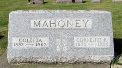
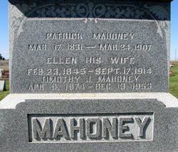
Cornelius R Mahoney
| Birth | : | 18 Aug 1875 Lincoln Township, Black Hawk County, Iowa, USA |
| Death | : | 1936 Lincoln Township, Black Hawk County, Iowa, USA |
| Burial | : | New Row Methodist Church, Blackburn with Darwen Unitary Authority, England |
| Coordinate | : | 53.7208950, -2.5023720 |
| Description | : | Traer star Clipper, Friday, January 17th, 1936 page 5 Funeral services for Cornelius Richard Mahoney, 60, who died at 6 a. m. Saturday at his home five miles southwest of Hudson, in Lincoln township, after a lingering illness of carcinoma, were held Tuesday morning in Immaculate Conception Catholic church at Blessing, the Rev. Father John Richard, pastor, officiating. Burial was in the Blessing cemetery. Mr. Mahoney, who had been in ill health for several months, was born on a farm in Lincoln township August 18, 1875, the son of Patrick and Helen Townsend Mahoney. All his life, except two... Read More |
frequently asked questions (FAQ):
-
Where is Cornelius R Mahoney's memorial?
Cornelius R Mahoney's memorial is located at: New Row Methodist Church, Blackburn with Darwen Unitary Authority, England.
-
When did Cornelius R Mahoney death?
Cornelius R Mahoney death on 1936 in Lincoln Township, Black Hawk County, Iowa, USA
-
Where are the coordinates of the Cornelius R Mahoney's memorial?
Latitude: 53.7208950
Longitude: -2.5023720
Family Members:
Parent


Spouse
Siblings
Flowers:


Nearby Cemetories:
1. New Row Methodist Church
Blackburn with Darwen Unitary Authority, England
Coordinate: 53.7208950, -2.5023720
2. St Stephen Churchyard
Tockholes, Blackburn with Darwen Unitary Authority, England
Coordinate: 53.7058350, -2.5169320
3. St James Churchyard
Lower Darwen, Blackburn with Darwen Unitary Authority, England
Coordinate: 53.7245510, -2.4634700
4. St. Peter's Churchyard
Blackburn, Blackburn with Darwen Unitary Authority, England
Coordinate: 53.7448110, -2.4865070
5. Independent Chapel Churchyard
Blackburn, Blackburn with Darwen Unitary Authority, England
Coordinate: 53.7454960, -2.4864460
6. Pleasington Cemetery and Crematorium
Blackburn, Blackburn with Darwen Unitary Authority, England
Coordinate: 53.7388880, -2.5368710
7. Wesleyan Methodist Chapel Chapelyard
Blackburn, Blackburn with Darwen Unitary Authority, England
Coordinate: 53.7464910, -2.4848380
8. Pleasington Priory
Pleasington, Blackburn with Darwen Unitary Authority, England
Coordinate: 53.7348590, -2.5433060
9. Blackburn Cathedral
Blackburn, Blackburn with Darwen Unitary Authority, England
Coordinate: 53.7472960, -2.4820020
10. St Paul's
Blackburn, Blackburn with Darwen Unitary Authority, England
Coordinate: 53.7491222, -2.4891266
11. Mount St Presbyterian Chapelyard
Blackburn, Blackburn with Darwen Unitary Authority, England
Coordinate: 53.7478000, -2.4775000
12. St Peters Churchyard
Darwen, Blackburn with Darwen Unitary Authority, England
Coordinate: 53.6955520, -2.4648090
13. Holy Trinity Church
Blackburn with Darwen Unitary Authority, England
Coordinate: 53.7511727, -2.4747178
14. St Alban's Churchyard
Blackburn, Blackburn with Darwen Unitary Authority, England
Coordinate: 53.7530090, -2.4748540
15. St Paul's Churchyard
Withnell, Chorley Borough, England
Coordinate: 53.6970740, -2.5592150
16. St. Paul's Churchyard
Darwen, Blackburn with Darwen Unitary Authority, England
Coordinate: 53.6979270, -2.4318640
17. Blackburn Cemetery
Blackburn, Blackburn with Darwen Unitary Authority, England
Coordinate: 53.7662430, -2.4726050
18. Holy Trinity Churchyard
Hoghton, Chorley Borough, England
Coordinate: 53.7279300, -2.5848550
19. Darwen Cemetery
Darwen, Blackburn with Darwen Unitary Authority, England
Coordinate: 53.6781400, -2.4598300
20. Darwen Eastern Cemetery
Darwen, Blackburn with Darwen Unitary Authority, England
Coordinate: 53.6769300, -2.4547700
21. St. Josephs Roman Catholic Churchyard
Brindle, Chorley Borough, England
Coordinate: 53.7350780, -2.5880640
22. Pickup Bank Congregational Chapel
Pickup Bank, Blackburn with Darwen Unitary Authority, England
Coordinate: 53.7012440, -2.4164220
23. St. Mary's Churchyard
Mellor, Ribble Valley Borough, England
Coordinate: 53.7728600, -2.5312400
24. Mellor Methodist Churchyard
Blackburn, Blackburn with Darwen Unitary Authority, England
Coordinate: 53.7742950, -2.5255060