| Birth | : | 30 Oct 1902 Schuyler County, Missouri, USA |
| Death | : | 30 Aug 1942 Ottumwa, Wapello County, Iowa, USA |
| Burial | : | Darwen Eastern Cemetery, Darwen, Blackburn with Darwen Unitary Authority, England |
| Coordinate | : | 53.6769300, -2.4547700 |
| Plot | : | Prospect Hill-Lot 245 |
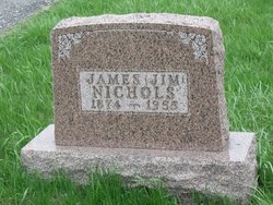
| Description | : | Obit posted in Ottumwa Courier August 30, 1942 Victim Of Morrell Plant Mishap Dies Injuries sustained early Saturday while he was working at the John Morrell & Co. plant proved fatal to Courtland "Bill" Nichols, 39, at 7:15 a.m. Sunday in the Ottumwa hospital. His home was at 838 Ellis avenue. Nichols was oiling some machinery in the Morrell beef house when he fell about 15 feet. He was found unconscious a few minutes later. He had worked at the plant for the past 13 years and was a millwright at the time of the accident. The son of James... Read More |
frequently asked questions (FAQ):
-
Where is Courtland Alfred Nichols's memorial?
Courtland Alfred Nichols's memorial is located at: Darwen Eastern Cemetery, Darwen, Blackburn with Darwen Unitary Authority, England.
-
When did Courtland Alfred Nichols death?
Courtland Alfred Nichols death on 30 Aug 1942 in Ottumwa, Wapello County, Iowa, USA
-
Where are the coordinates of the Courtland Alfred Nichols's memorial?
Latitude: 53.6769300
Longitude: -2.4547700
Family Members:
Parent
Spouse
Siblings
Children
Flowers:
Nearby Cemetories:
1. Darwen Eastern Cemetery
Darwen, Blackburn with Darwen Unitary Authority, England
Coordinate: 53.6769300, -2.4547700
2. Darwen Cemetery
Darwen, Blackburn with Darwen Unitary Authority, England
Coordinate: 53.6781400, -2.4598300
3. St Peters Churchyard
Darwen, Blackburn with Darwen Unitary Authority, England
Coordinate: 53.6955520, -2.4648090
4. St. Paul's Churchyard
Darwen, Blackburn with Darwen Unitary Authority, England
Coordinate: 53.6979270, -2.4318640
5. Pickup Bank Congregational Chapel
Pickup Bank, Blackburn with Darwen Unitary Authority, England
Coordinate: 53.7012440, -2.4164220
6. Belmont Congregational Churchyard
Belmont, Blackburn with Darwen Unitary Authority, England
Coordinate: 53.6419917, -2.4955512
7. Edgworth Congregational Chapelyard
Edgworth, Blackburn with Darwen Unitary Authority, England
Coordinate: 53.6476280, -2.3967210
8. St Peter Churchyard
Belmont, Blackburn with Darwen Unitary Authority, England
Coordinate: 53.6379520, -2.4955480
9. St Stephen Churchyard
Tockholes, Blackburn with Darwen Unitary Authority, England
Coordinate: 53.7058350, -2.5169320
10. St James Churchyard
Lower Darwen, Blackburn with Darwen Unitary Authority, England
Coordinate: 53.7245510, -2.4634700
11. Methodist Church Churchyard
Edgworth, Blackburn with Darwen Unitary Authority, England
Coordinate: 53.6424280, -2.3962830
12. St. Anne's Churchyard
Chapeltown, Blackburn with Darwen Unitary Authority, England
Coordinate: 53.6371710, -2.4030440
13. New Row Methodist Church
Blackburn with Darwen Unitary Authority, England
Coordinate: 53.7208950, -2.5023720
14. Christ Church Churchyard
Egerton, Metropolitan Borough of Bolton, England
Coordinate: 53.6237080, -2.4389210
15. Haslingden Grane Methodist Chapel Cemetery
Haslingden, Rossendale Borough, England
Coordinate: 53.7016300, -2.3728190
16. St Paul's Churchyard
Withnell, Chorley Borough, England
Coordinate: 53.6970740, -2.5592150
17. Immanuel Churchyard
Oswaldwistle, Hyndburn Borough, England
Coordinate: 53.7358300, -2.4056200
18. New Lane Baptist Chapel Chapelyard
Oswaldwistle, Hyndburn Borough, England
Coordinate: 53.7381100, -2.4049500
19. Hawkshaw Methodist Church Cemetery
Hawkshaw, Metropolitan Borough of Bury, England
Coordinate: 53.6313490, -2.3674190
20. Haslingden Cemetery
Haslingden, Rossendale Borough, England
Coordinate: 53.6989500, -2.3427700
21. Holden Hall Cemetery
Haslingden, Rossendale Borough, England
Coordinate: 53.6989870, -2.3427780
22. St. Peter's Churchyard
Blackburn, Blackburn with Darwen Unitary Authority, England
Coordinate: 53.7448110, -2.4865070
23. Independent Chapel Churchyard
Blackburn, Blackburn with Darwen Unitary Authority, England
Coordinate: 53.7454960, -2.4864460
24. St Mary Churchyard
Hawkshaw, Metropolitan Borough of Bury, England
Coordinate: 53.6307270, -2.3636210


