
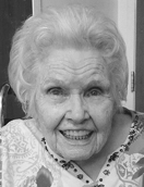
Crystle Edythe Wyvonne Sherman Widdis
| Birth | : | 25 Feb 1916 Burwell, Garfield County, Nebraska, USA |
| Death | : | 23 Feb 2016 Montana, USA |
| Burial | : | Rudyard Cemetery, Rudyard, Hill County, USA |
| Coordinate | : | 48.5659500, -110.5390000 |
| Description | : | Crystle Widdis, a Rudyard area farm wife and homemaker, passed away peacefully at the Liberty County Nursing Home in Chester on Tuesday evening (February 23rd, 2016). She died just two days before her 100th birthday. Crystle Edythe Wyvonne Sherman was born February 25th, 1916 at Burwell, Nebraska. She was the oldest of nine children born to Edgar & Nina (Butcher) Sherman. Crystle was baptized in a river near Burwell as a teen. She received her formal education at Burwell, where she graduated from high school in 1934. Crystle continued her schooling at a Teacher’s College in... Read More |
frequently asked questions (FAQ):
-
Where is Crystle Edythe Wyvonne Sherman Widdis's memorial?
Crystle Edythe Wyvonne Sherman Widdis's memorial is located at: Rudyard Cemetery, Rudyard, Hill County, USA.
-
When did Crystle Edythe Wyvonne Sherman Widdis death?
Crystle Edythe Wyvonne Sherman Widdis death on 23 Feb 2016 in Montana, USA
-
Where are the coordinates of the Crystle Edythe Wyvonne Sherman Widdis's memorial?
Latitude: 48.5659500
Longitude: -110.5390000
Family Members:
Parent

Siblings
Flowers:


Nearby Cemetories:
1. Rudyard Cemetery
Rudyard, Hill County, USA
Coordinate: 48.5659500, -110.5390000
2. Hingham Union Cemetery
Hingham, Hill County, USA
Coordinate: 48.5601570, -110.4178980
3. Inverness Cemetery
Hill County, USA
Coordinate: 48.5531340, -110.6688450
4. Bethel Cemetery
Hill County, USA
Coordinate: 48.6685982, -110.6406021
5. Joplin Cemetery
Joplin, Liberty County, USA
Coordinate: 48.5576720, -110.7622930
6. Gildford Hill County Cemetery
Gildford, Hill County, USA
Coordinate: 48.5778008, -110.2957993
7. Cool Spring Colony Cemetery
Rudyard, Hill County, USA
Coordinate: 48.7704000, -110.5860000
8. Milk River Valley Church Graveyard
Hill County, USA
Coordinate: 48.6787180, -110.2261080
9. Cottonwood Lutheran Church Cemetery
Havre, Hill County, USA
Coordinate: 48.4545000, -110.1748000
10. Grace Church Cemetery
Rudyard, Hill County, USA
Coordinate: 48.8269930, -110.6209890
11. Chester Cemetery
Chester, Liberty County, USA
Coordinate: 48.5219002, -110.9807968
12. Saint Wenceslaus Cemetery
Goldstone, Hill County, USA
Coordinate: 48.9002610, -110.5310160
13. Kenilworth Cemetery
Chouteau County, USA
Coordinate: 48.2192001, -110.4188995
14. Erickson Cemetery
Liberty County, USA
Coordinate: 48.3143997, -110.9503021
15. Spring Coulee Cemetery
Hill County, USA
Coordinate: 48.9138985, -110.2035980
16. Box Elder Cemetery
Box Elder, Hill County, USA
Coordinate: 48.3274000, -110.0095000
17. Saint Johns Catholic Cemetery
Havre, Hill County, USA
Coordinate: 48.7625008, -109.9638977
18. Eagle Creek Colony Cemetery
Chester, Liberty County, USA
Coordinate: 48.6976000, -111.2011000
19. Grainbelt Cemetery
Hill County, USA
Coordinate: 48.6828003, -109.8657990
20. Sage Creek Colony Cemetery
Sage Creek Colony, Liberty County, USA
Coordinate: 48.9271000, -110.9735000
21. Lothair Protestant Cemetery
Lothair, Liberty County, USA
Coordinate: 48.4694000, -111.2393100
22. Big Sandy Cemetery
Big Sandy, Chouteau County, USA
Coordinate: 48.1801170, -110.1207500
23. Lothair Catholic Cemetery
Lothair, Liberty County, USA
Coordinate: 48.4687000, -111.2484000
24. Trinity Church Cemetery
Lothair, Liberty County, USA
Coordinate: 48.7263000, -111.2296000