

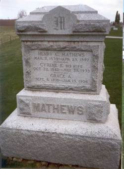
Cyrene Eveline Dodds Mathews
| Birth | : | 22 Oct 1842 Danville, Des Moines County, Iowa, USA |
| Death | : | 28 Jul 1933 |
| Burial | : | St. Andrew's Churchyard, Hornchurch, London Borough of Havering, England |
| Coordinate | : | 51.5604880, 0.2260780 |
| Description | : | Wife of Henry Clay Mathews-mother to eight children |
frequently asked questions (FAQ):
-
Where is Cyrene Eveline Dodds Mathews's memorial?
Cyrene Eveline Dodds Mathews's memorial is located at: St. Andrew's Churchyard, Hornchurch, London Borough of Havering, England.
-
When did Cyrene Eveline Dodds Mathews death?
Cyrene Eveline Dodds Mathews death on 28 Jul 1933 in
-
Where are the coordinates of the Cyrene Eveline Dodds Mathews's memorial?
Latitude: 51.5604880
Longitude: 0.2260780
Family Members:
Parent

Spouse

Siblings

Children
Flowers:


Nearby Cemetories:
1. St. Andrew's Churchyard
Hornchurch, London Borough of Havering, England
Coordinate: 51.5604880, 0.2260780
2. Hornchurch Cemetery
Hornchurch, London Borough of Havering, England
Coordinate: 51.5590370, 0.2264210
3. St Laurence Churchyard
Upminster, London Borough of Havering, England
Coordinate: 51.5557430, 0.2478680
4. All Saints Churchyard
Cranham, London Borough of Havering, England
Coordinate: 51.5522750, 0.2660270
5. South Essex Crematorium
Upminster, London Borough of Havering, England
Coordinate: 51.5433380, 0.2583840
6. Upminster Cemetery
Corbets Tey, London Borough of Havering, England
Coordinate: 51.5433330, 0.2592730
7. Eastbrookend Cemetery
Dagenham, London Borough of Barking and Dagenham, England
Coordinate: 51.5553150, 0.1820900
8. St. Andrew's Churchyard
Romford, London Borough of Havering, England
Coordinate: 51.5714570, 0.1837630
9. Romford Cemetery
Romford, London Borough of Havering, England
Coordinate: 51.5693810, 0.1746850
10. St Andrew's Church
Romford, London Borough of Havering, England
Coordinate: 51.5757696, 0.1728658
11. Rainham Jewish Cemetery
Rainham, London Borough of Havering, England
Coordinate: 51.5226300, 0.2216150
12. Rainham Cemetery
Rainham, London Borough of Havering, England
Coordinate: 51.5221490, 0.2099420
13. St. Mary Magdalene Churchyard
North Ockendon, London Borough of Havering, England
Coordinate: 51.5404030, 0.2875930
14. St. Peter and St. Paul Churchyard
Dagenham, London Borough of Barking and Dagenham, England
Coordinate: 51.5397240, 0.1620340
15. St Helen and St Giles Churchyard
Rainham, London Borough of Havering, England
Coordinate: 51.5183040, 0.1905660
16. St Mary the Virgin Churchyard
Great Warley, Brentwood Borough, England
Coordinate: 51.5863490, 0.2920150
17. The Old Churchyard
Great Warley, Brentwood Borough, England
Coordinate: 51.5719550, 0.3023490
18. St Mary and St Peter Churchyard
Wennington, London Borough of Havering, England
Coordinate: 51.5064790, 0.2173980
19. St. Peter Churchyard
Little Warley, Brentwood Borough, England
Coordinate: 51.5738020, 0.3138180
20. Cherry Orchard Congregational Church
South Ockendon, Thurrock Unitary Authority, England
Coordinate: 51.5241770, 0.2976050
21. Chadwell Heath Cemetery
London Borough of Barking and Dagenham, England
Coordinate: 51.5861092, 0.1414030
22. St. Nicholas Churchyard
South Ockendon, Thurrock Unitary Authority, England
Coordinate: 51.5224830, 0.2976820
23. South Ockendon Cemetery
South Ockendon, Thurrock Unitary Authority, England
Coordinate: 51.5226000, 0.2988650
24. St. John the Evangelist Churchyard
Havering-atte-Bower, London Borough of Havering, England
Coordinate: 51.6161750, 0.1823690