
| Memorials | : | 130 |
| Location | : | Cranham, London Borough of Havering, England |
| Coordinate | : | 51.5522750, 0.2660270 |
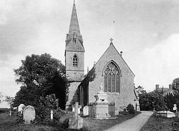
| Description | : | Cranham is a place in the London Borough of Havering. on the northern flood plain of the River Thames, about 18 miles from London.Its name is first recorded in 1086 as Craohv or "Cravoho". The -oho suffix means a spur of land or a ridge in the landscape, sometimes appearing modernly as a "Hoo" Locally, Cranham is still sometimes referred to as a village despite forming the easternmost edge of London's suburbs. From 1894 Cranham parish formed part of the Romford Rural District of Essex. All Saints Church is recorded from as early as 1254. It comprises nave, chancel,... Read More |
frequently asked questions (FAQ):
-
Where is All Saints Churchyard?
All Saints Churchyard is located at The Chase Cranham, London Borough of Havering ,Greater London , RM14 3YBEngland.
-
All Saints Churchyard cemetery's updated grave count on graveviews.com?
130 memorials
-
Where are the coordinates of the All Saints Churchyard?
Latitude: 51.5522750
Longitude: 0.2660270
Nearby Cemetories:
1. Upminster Cemetery
Corbets Tey, London Borough of Havering, England
Coordinate: 51.5433330, 0.2592730
2. South Essex Crematorium
Upminster, London Borough of Havering, England
Coordinate: 51.5433380, 0.2583840
3. St Laurence Churchyard
Upminster, London Borough of Havering, England
Coordinate: 51.5557430, 0.2478680
4. St. Mary Magdalene Churchyard
North Ockendon, London Borough of Havering, England
Coordinate: 51.5404030, 0.2875930
5. Hornchurch Cemetery
Hornchurch, London Borough of Havering, England
Coordinate: 51.5590370, 0.2264210
6. St. Andrew's Churchyard
Hornchurch, London Borough of Havering, England
Coordinate: 51.5604880, 0.2260780
7. The Old Churchyard
Great Warley, Brentwood Borough, England
Coordinate: 51.5719550, 0.3023490
8. Cherry Orchard Congregational Church
South Ockendon, Thurrock Unitary Authority, England
Coordinate: 51.5241770, 0.2976050
9. St. Nicholas Churchyard
South Ockendon, Thurrock Unitary Authority, England
Coordinate: 51.5224830, 0.2976820
10. South Ockendon Cemetery
South Ockendon, Thurrock Unitary Authority, England
Coordinate: 51.5226000, 0.2988650
11. St. Peter Churchyard
Little Warley, Brentwood Borough, England
Coordinate: 51.5738020, 0.3138180
12. St Mary the Virgin Churchyard
Great Warley, Brentwood Borough, England
Coordinate: 51.5863490, 0.2920150
13. Rainham Jewish Cemetery
Rainham, London Borough of Havering, England
Coordinate: 51.5226300, 0.2216150
14. Rainham Cemetery
Rainham, London Borough of Havering, England
Coordinate: 51.5221490, 0.2099420
15. All Saints and Saint Faith Churchyard
Childerditch, Brentwood Borough, England
Coordinate: 51.5796560, 0.3278980
16. Eastbrookend Cemetery
Dagenham, London Borough of Barking and Dagenham, England
Coordinate: 51.5553150, 0.1820900
17. St. Michael’s Churchyard
Aveley, Thurrock Unitary Authority, England
Coordinate: 51.4980160, 0.2568560
18. St. Andrew's Churchyard
Romford, London Borough of Havering, England
Coordinate: 51.5714570, 0.1837630
19. St Mary and St Peter Churchyard
Wennington, London Borough of Havering, England
Coordinate: 51.5064790, 0.2173980
20. St Helen and St Giles Churchyard
Rainham, London Borough of Havering, England
Coordinate: 51.5183040, 0.1905660
21. St Mary the Virgin Churchyard
Bulphan, Thurrock Unitary Authority, England
Coordinate: 51.5476280, 0.3591910
22. Romford Cemetery
Romford, London Borough of Havering, England
Coordinate: 51.5693810, 0.1746850
23. Lorne Road Cemetery
Great Warley, Brentwood Borough, England
Coordinate: 51.6091530, 0.2969270
24. Lorne Road Cemetery
Brentwood, Brentwood Borough, England
Coordinate: 51.6107450, 0.2894590