
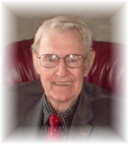


Dale Herbert Mauer
| Birth | : | 23 Apr 1923 Plainview, Pierce County, Nebraska, USA |
| Death | : | 6 Sep 2007 Norwalk, Warren County, Iowa, USA |
| Burial | : | Camellia Memorial Lawn Cemetery, Sacramento, Sacramento County, USA |
| Coordinate | : | 38.5242004, -121.3097000 |
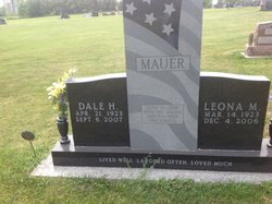
| Inscription | : | Front of stone: Gone to Soar with the Eagles and fly with The Angels Lived Well, Laughed often, Loved Much Back of stone: Dale H. Mauer AVN CADET US ARMY AIR FORCES APR. 21 1923 SE |
| Description | : | Dale H. Mauer, 84, of Afton, died Thursday, September 6, 2007 at the Regency Care Center in Norwalk, Iowa. Dale Herbert Mauer, son of Myrtle Lillian (Blomquist) and Charles John Mauer was born April 21, 1923 in Plainview, Neb. Dale graduated from Plainview High School in 1941. After helping his father for a short time on the farm he joined the United States Air Force in 1944. Dale married Leona Mae (Stoltzman) in San Angelo, Texas April 24, 1945, while in the Air Force. After his Military service they returned to Plainview, Neb. where he continued to help out on... Read More |
frequently asked questions (FAQ):
-
Where is Dale Herbert Mauer's memorial?
Dale Herbert Mauer's memorial is located at: Camellia Memorial Lawn Cemetery, Sacramento, Sacramento County, USA.
-
When did Dale Herbert Mauer death?
Dale Herbert Mauer death on 6 Sep 2007 in Norwalk, Warren County, Iowa, USA
-
Where are the coordinates of the Dale Herbert Mauer's memorial?
Latitude: 38.5242004
Longitude: -121.3097000
Family Members:
Parent

Spouse
Siblings
Flowers:


Nearby Cemetories:
1. Camellia Memorial Lawn Cemetery
Sacramento, Sacramento County, USA
Coordinate: 38.5242004, -121.3097000
2. Bellview Cemetery
Sacramento, Sacramento County, USA
Coordinate: 38.5153580, -121.3257446
3. Quiet Haven Memorial Park Cemetery
Sacramento, Sacramento County, USA
Coordinate: 38.5109711, -121.3245621
4. Greater Sacramento Muslim Cemetery
Sacramento, Sacramento County, USA
Coordinate: 38.5128300, -121.2616800
5. Sacramento Pet Cemetery
Sacramento, Sacramento County, USA
Coordinate: 38.4815870, -121.3402080
6. Chua Phuoc Thien Temple Columbarium
Sacramento, Sacramento County, USA
Coordinate: 38.4555400, -121.3345500
7. Kilgore Cemetery
Rancho Cordova, Sacramento County, USA
Coordinate: 38.5978012, -121.2683029
8. Tinh Xa Ngoc An Temple Columbarium
Sacramento, Sacramento County, USA
Coordinate: 38.5190200, -121.4159500
9. Elder Creek Cemetery
Florin, Sacramento County, USA
Coordinate: 38.5111008, -121.4169006
10. Union Cemetery
Sacramento County, USA
Coordinate: 38.4477997, -121.2619019
11. Saint Michaels Episcopal Church Columbarium
Carmichael, Sacramento County, USA
Coordinate: 38.6042800, -121.3547200
12. Sacramento County Cemetery
Sacramento County, USA
Coordinate: 38.5267900, -121.4233700
13. Sacramento County Veterans Memorial Cemetery
Sacramento, Sacramento County, USA
Coordinate: 38.5252838, -121.4239120
14. Sacramento County Hospital Cemetery
Sacramento, Sacramento County, USA
Coordinate: 38.5289300, -121.4239100
15. Russian Orthodox Cemetery
Sacramento, Sacramento County, USA
Coordinate: 38.5268800, -121.4244300
16. Saint Mary's Catholic Cemetery and Mausoleum
Sacramento, Sacramento County, USA
Coordinate: 38.5298900, -121.4261200
17. Pleasant Grove Cemetery
Elk Grove, Sacramento County, USA
Coordinate: 38.4302220, -121.3107670
18. Carmichael Presbyterian Church Columbarium
Carmichael, Sacramento County, USA
Coordinate: 38.6179500, -121.3324500
19. Sloughhouse Pioneer Cemetery
Sloughhouse, Sacramento County, USA
Coordinate: 38.4950130, -121.1916080
20. Saint Marks Methodist Church Memorial Tree
Sacramento, Sacramento County, USA
Coordinate: 38.6076500, -121.3750680
21. Kim Quang Temple Columbarium
Sacramento, Sacramento County, USA
Coordinate: 38.5996600, -121.3904700
22. Sacramento Memorial Lawn Cemetery
Sacramento, Sacramento County, USA
Coordinate: 38.5146484, -121.4380341
23. Home of Peace Cemetery
Sacramento, Sacramento County, USA
Coordinate: 38.5137558, -121.4382782
24. San Joaquin Cemetery
Sacramento, Sacramento County, USA
Coordinate: 38.4387665, -121.4034653