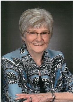
| Birth | : | 24 Nov 1927 Lamont, Buchanan County, Iowa, USA |
| Death | : | 7 Oct 2008 Oelwein, Fayette County, Iowa, USA |
| Burial | : | Clarks Grove Cemetery, Maryville, Blount County, USA |
| Coordinate | : | 35.8093987, -83.9413986 |
| Description | : | Dale L. "Bud" Rosenstiel, 80, of Oelwein, died Tuesday, Oct. 7, at Grandview Care Center, Oelwein, after a long illness. He was born Nov. 24, 1927, on the family farm near Lamont, son of Loren and Elsie Falck Rosenstiel. He married Anne Pirillo on March 19, 1951, in Oelwein. She preceded him in death. Mr. Rosenstiel attended Independence School System, then served in the U.S. Navy during World War II in the Mariana Islands in the Philippines. He was employed as a truck driver and farm equipment salesman. Survived by: two daughters, JoAnn "Joni" Moore-Daugherty of Ankeny and Jean Rosenstiel of Oelwein; two... Read More |
frequently asked questions (FAQ):
-
Where is Dale L “Bud” Rosenstiel's memorial?
Dale L “Bud” Rosenstiel's memorial is located at: Clarks Grove Cemetery, Maryville, Blount County, USA.
-
When did Dale L “Bud” Rosenstiel death?
Dale L “Bud” Rosenstiel death on 7 Oct 2008 in Oelwein, Fayette County, Iowa, USA
-
Where are the coordinates of the Dale L “Bud” Rosenstiel's memorial?
Latitude: 35.8093987
Longitude: -83.9413986
Family Members:
Parent
Spouse
Siblings
Flowers:
Nearby Cemetories:
1. Clarks Grove Cemetery
Maryville, Blount County, USA
Coordinate: 35.8093987, -83.9413986
2. Mount Pleasant AME Zion Church Cemetery
Rockford, Blount County, USA
Coordinate: 35.8212340, -83.9555720
3. Old Mount Lebanon Cemetery
Eagleton Village, Blount County, USA
Coordinate: 35.7991982, -83.9210968
4. Brantleys Chapel Cemetery
Maryville, Blount County, USA
Coordinate: 35.7825600, -83.9436600
5. Sherwood Chapel and Memorial Gardens
Alcoa, Blount County, USA
Coordinate: 35.8283005, -83.9732971
6. Mount Lebanon Cemetery
Maryville, Blount County, USA
Coordinate: 35.7949982, -83.9057999
7. East Maryville Baptist Cemetery
Maryville, Blount County, USA
Coordinate: 35.7708015, -83.9332962
8. Wesley Ann Methodist Cemetery
Rockford, Blount County, USA
Coordinate: 35.8492000, -83.9361000
9. Vineyard Cemetery
Blount County, USA
Coordinate: 35.8400002, -83.9057999
10. Kirby Family Cemetery
Blount County, USA
Coordinate: 35.8527985, -83.9496994
11. Wilders Chapel Cemetery
Blount County, USA
Coordinate: 35.7653008, -83.9263992
12. Harris Cemetery
Blount County, USA
Coordinate: 35.8555984, -83.9297028
13. Cedar Lawn Cemetery
Blount County, USA
Coordinate: 35.7806015, -83.9878006
14. Central Point Baptist Church Cemetery
Blount County, USA
Coordinate: 35.8260994, -83.8855972
15. Edington Cemetery
Blount County, USA
Coordinate: 35.8546982, -83.9197006
16. Mount Moriah Cemetery
Blount County, USA
Coordinate: 35.8531700, -83.9684500
17. Taylor Cemetery
Blount County, USA
Coordinate: 35.8274994, -83.9982986
18. Our Lady of Fatima Catholic Church Columbarium
Alcoa, Blount County, USA
Coordinate: 35.7744140, -83.9901060
19. Mount Gilead Methodist Cemetery
Alcoa, Blount County, USA
Coordinate: 35.7619800, -83.9706000
20. Slave Cemetery
Blount County, USA
Coordinate: 35.8241997, -83.8768997
21. Logans Chapel Cemetery
Maryville, Blount County, USA
Coordinate: 35.8046989, -83.8731003
22. Centennial Cemetery
Maryville, Blount County, USA
Coordinate: 35.7606642, -83.9771331
23. Centennial Cemetery
Blount County, USA
Coordinate: 35.7672005, -83.8908005
24. George Cemetery
Blount County, USA
Coordinate: 35.8424988, -84.0028000


