
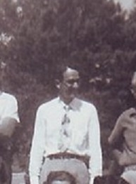
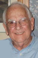
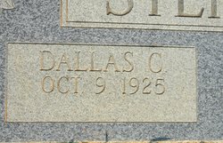
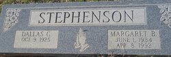
Dallas Culp Stephenson
| Birth | : | 9 Oct 1925 |
| Death | : | 17 Jan 2011 Rock Hill, York County, South Carolina, USA |
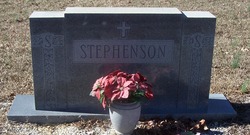
| Burial | : | Pleasant Hill United Methodist Church Cemetery, Indian Land, Lancaster County, USA |
| Coordinate | : | 35.0006960, -80.8620870 |
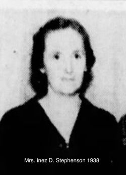
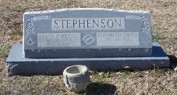
| Description | : | ..Obit::: -TEGA CAY – Dallas Culp Stephenson, 85, died Monday, Jan. 17, 2011. -He was the son of the late Frank and Inez Stephenson. He was a World War II Navy veteran. -Survivors include three sons, Gregg, Martin and Brian and his wife, Jennifer; a grandson, Dallas; the love of his life, Dot Telis; a sister, Lavinia "Bennie'' Lynch; and nieces and nephews. -Family visitation will be at 10 a.m., Saturday, Jan. 22, at Pleasant Hill United Methodist Church, followed by services at 11 a.m. -All are invited for refreshments, music and reminiscing in the fellowship hall following the service. -Memorials may be made to Hospice... Read More |
frequently asked questions (FAQ):
-
Where is Dallas Culp Stephenson's memorial?
Dallas Culp Stephenson's memorial is located at: Pleasant Hill United Methodist Church Cemetery, Indian Land, Lancaster County, USA.
-
When did Dallas Culp Stephenson death?
Dallas Culp Stephenson death on 17 Jan 2011 in Rock Hill, York County, South Carolina, USA
-
Where are the coordinates of the Dallas Culp Stephenson's memorial?
Latitude: 35.0006960
Longitude: -80.8620870
Family Members:
Parent
Spouse
Siblings

Children
Flowers:


Nearby Cemetories:
1. Pleasant Hill United Methodist Church Cemetery
Indian Land, Lancaster County, USA
Coordinate: 35.0006960, -80.8620870
2. Pleasant Valley Baptist Church Cemetery
Lancaster County, USA
Coordinate: 34.9931793, -80.8495407
3. Silver Run Cemetery
Lancaster County, USA
Coordinate: 35.0149994, -80.8561020
4. Silver Hill Cemetery
Indian Land, Lancaster County, USA
Coordinate: 35.0149280, -80.8557590
5. Independent Bible Baptist Church Cemetery
Charlotte, Mecklenburg County, USA
Coordinate: 35.0179990, -80.8488210
6. Edwards Cemetery
Indian Land, Lancaster County, USA
Coordinate: 34.9770010, -80.8607570
7. Higher Ground Church Cemetery
Indian Land, Lancaster County, USA
Coordinate: 34.9713300, -80.8597020
8. Indian Hill AME Zion Church Cemetery
Indian Land, Lancaster County, USA
Coordinate: 35.0318830, -80.8775660
9. Banks Presbyterian Church Cemetery
Marvin, Union County, USA
Coordinate: 34.9930305, -80.8189697
10. Marvin United Methodist Church Cemetery
Marvin, Union County, USA
Coordinate: 34.9928894, -80.8166580
11. Harrison United Methodist Church Cemetery
Pineville, Mecklenburg County, USA
Coordinate: 35.0415450, -80.8637550
12. Big Pineville AME Zion Church and Cemetery
Pineville, Mecklenburg County, USA
Coordinate: 35.0466280, -80.8562640
13. Elbethel AME Zion Church Cemetery
Belair, Lancaster County, USA
Coordinate: 34.9626270, -80.8299860
14. Old Pleasant Valley Church Cemetery
Fort Mill, York County, USA
Coordinate: 34.9926280, -80.9181210
15. Marvin AME Zion Church Cemetery
Waxhaw, Union County, USA
Coordinate: 34.9920000, -80.8040000
16. Belair Methodist Church Cemetery
Lancaster County, USA
Coordinate: 34.9509964, -80.8433228
17. Old Elbethel AME Zion Church Cemetery
Indian Land, Lancaster County, USA
Coordinate: 34.9631250, -80.8125350
18. Green Hill Cemetery
Fort Mill, York County, USA
Coordinate: 35.0130150, -80.9293700
19. Macedonia Presbyterian Cemetery
Fort Mill, York County, USA
Coordinate: 35.0120690, -80.9331190
20. Old Six Mile Cemetery
Indian Land, Lancaster County, USA
Coordinate: 34.9484250, -80.8220320
21. Unity Cemetery
Fort Mill, York County, USA
Coordinate: 35.0076675, -80.9372864
22. Old Unity Cemetery
Fort Mill, York County, USA
Coordinate: 35.0155230, -80.9360810
23. Unity Presbyterian Church Columbarium
Fort Mill, York County, USA
Coordinate: 35.0080102, -80.9383740
24. Church of God Cemetery
Fort Mill, York County, USA
Coordinate: 34.9934820, -80.9433610