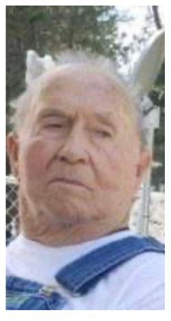
Daniel Edward “Dan” Handford
| Birth | : | 29 Oct 1937 Conrad, Pondera County, Montana, USA |
| Death | : | 11 Jan 2020 Missoula, Missoula County, Montana, USA |
| Burial | : | Fraternal Cemetery, Thompson Falls, Sanders County, USA |
| Coordinate | : | 47.5963000, -115.3365000 |
| Description | : | Daniel Edward Handford was born to Robert and Goldie Handford October 29, 1937 in Conrad, Montana. He was raised on his parents’ farm in Valier, Montana, until the age of nine when they moved to Great Falls and he attended school until he graduated. Dan worked at several construction companies over the years, the last being the Polson branch of Flathead Concrete. Earlier in Dan’s life he worked at the Zonolite Mine in Libby for approximately 10 years. Dan served as a dispatcher for the Lake County Sheriff’s Department and was a reserve deputy prior to remarrying. Dan married Betty... Read More |
frequently asked questions (FAQ):
-
Where is Daniel Edward “Dan” Handford's memorial?
Daniel Edward “Dan” Handford's memorial is located at: Fraternal Cemetery, Thompson Falls, Sanders County, USA.
-
When did Daniel Edward “Dan” Handford death?
Daniel Edward “Dan” Handford death on 11 Jan 2020 in Missoula, Missoula County, Montana, USA
-
Where are the coordinates of the Daniel Edward “Dan” Handford's memorial?
Latitude: 47.5963000
Longitude: -115.3365000
Family Members:
Parent
Spouse
Siblings
Children
Flowers:
Nearby Cemetories:
1. Fraternal Cemetery
Thompson Falls, Sanders County, USA
Coordinate: 47.5963000, -115.3365000
2. Wild Rose Cemetery
Thompson Falls, Sanders County, USA
Coordinate: 47.5964000, -115.3380000
3. Thompson Falls Cemetery
Thompson Falls, Sanders County, USA
Coordinate: 47.5956950, -115.3271560
4. Whitepine Cemetery
White Pine, Sanders County, USA
Coordinate: 47.7682991, -115.5077972
5. Saltese Cemetery
Saltese, Mineral County, USA
Coordinate: 47.4125000, -115.5152000
6. De Borgia Cemetery
De Borgia, Mineral County, USA
Coordinate: 47.3712650, -115.3386890
7. Dominion Peak Gravesite
Haugan, Mineral County, USA
Coordinate: 47.3675130, -115.5777060
8. Plains Cemetery
Plains, Sanders County, USA
Coordinate: 47.4728660, -114.8820000
9. IOOF Cemetery
Mullan, Shoshone County, USA
Coordinate: 47.4667160, -115.7905450
10. Mountain View Cemetery
Mullan, Shoshone County, USA
Coordinate: 47.4655100, -115.7908000
11. Saint Regis Cemetery
Saint Regis, Mineral County, USA
Coordinate: 47.3058770, -115.0893880
12. Lynch Family Cemetery
Plains, Sanders County, USA
Coordinate: 47.4560000, -114.8750000
13. Fairmont Cemetery
Mullan, Shoshone County, USA
Coordinate: 47.4665000, -115.8064000
14. Murray Cemetery
Shoshone County, USA
Coordinate: 47.6241600, -115.8648700
15. Miners Union Cemetery
Mullan, Shoshone County, USA
Coordinate: 47.4885600, -115.9144700
16. Nine Mile Cemetery
Wallace, Shoshone County, USA
Coordinate: 47.4893000, -115.9154000
17. Paradise Cemetery
Paradise, Sanders County, USA
Coordinate: 47.3864030, -114.7950910
18. Maillet Cemetery
Hot Springs, Sanders County, USA
Coordinate: 47.6128006, -114.6772003
19. Days Cemetery
Osburn, Shoshone County, USA
Coordinate: 47.5049500, -116.0081800
20. Hominsto Cemetery
Sanders County, USA
Coordinate: 47.4623000, -114.6784000
21. Ventling Cemetery
Sanders County, USA
Coordinate: 47.6232986, -114.6466980
22. Camas Prairie Cemetery
Sanders County, USA
Coordinate: 47.4319000, -114.6641998
23. Markle Cemetery
Hot Springs, Sanders County, USA
Coordinate: 47.5732994, -114.6200027
24. Murray Memorial Cemetery
Lonepine, Sanders County, USA
Coordinate: 47.7038994, -114.6335983


