
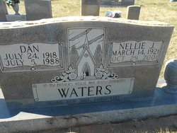
Daniel H. “Dan” Waters
| Birth | : | 24 Jul 1918 Rutherford County, North Carolina, USA |
| Death | : | 5 Jul 1988 Forest City, Rutherford County, North Carolina, USA |
| Burial | : | Sandy Level Baptist Cemetery, Bostic, Rutherford County, USA |
| Coordinate | : | 35.4591400, -81.8520440 |
frequently asked questions (FAQ):
-
Where is Daniel H. “Dan” Waters's memorial?
Daniel H. “Dan” Waters's memorial is located at: Sandy Level Baptist Cemetery, Bostic, Rutherford County, USA.
-
When did Daniel H. “Dan” Waters death?
Daniel H. “Dan” Waters death on 5 Jul 1988 in Forest City, Rutherford County, North Carolina, USA
-
Where are the coordinates of the Daniel H. “Dan” Waters's memorial?
Latitude: 35.4591400
Longitude: -81.8520440
Family Members:
Parent
Spouse

Siblings

Children


Nearby Cemetories:
1. Sandy Level Baptist Cemetery
Bostic, Rutherford County, USA
Coordinate: 35.4591400, -81.8520440
2. Brittain Cemetery
Rutherfordton, Rutherford County, USA
Coordinate: 35.4530983, -81.8861008
3. Mount Lebanon Cemetery
Rutherford County, USA
Coordinate: 35.4319000, -81.8414001
4. Pisgah United Methodist Church Cemetery
Rutherfordton, Rutherford County, USA
Coordinate: 35.4770130, -81.8799750
5. Wilson Baptist Cemetery
Forest City, Rutherford County, USA
Coordinate: 35.4257164, -81.8531723
6. Westminister Baptist Church Cemetery
Rutherfordton, Rutherford County, USA
Coordinate: 35.4647750, -81.8927880
7. Duggar Freeman Cemetery
Rutherford County, USA
Coordinate: 35.4247780, -81.8585810
8. Cedar Grove United Methodist Church Cemetery
Rutherford County, USA
Coordinate: 35.4506110, -81.8097540
9. Mount Harmony Baptist Church Cemetery
Bostic, Rutherford County, USA
Coordinate: 35.4588380, -81.7996940
10. Sunshine United Methodist Church Cemetery
Bostic, Rutherford County, USA
Coordinate: 35.4286930, -81.8132680
11. Ross Hill Baptist Church Cemetery
Bostic, Rutherford County, USA
Coordinate: 35.4575280, -81.7922220
12. Hollifield Family Cemetery
Bostic, Rutherford County, USA
Coordinate: 35.4203956, -81.8117291
13. Mountain View Baptist Church Cemetery
Bostic, Rutherford County, USA
Coordinate: 35.4227630, -81.8080460
14. Cansler Cemetery
Sunshine, Rutherford County, USA
Coordinate: 35.4082600, -81.8350400
15. Centennial Cemetery
Rutherford County, USA
Coordinate: 35.4655991, -81.9206009
16. Cooper Springs Congregational Holiness Church Ceme
Rutherford County, USA
Coordinate: 35.4755700, -81.7844540
17. Cane Creek Baptist Church Cemetery
Union Mills, Rutherford County, USA
Coordinate: 35.5222250, -81.8530630
18. New Vernon Baptist Cemetery
Bostic, Rutherford County, USA
Coordinate: 35.3958320, -81.8497430
19. Mount Vernon Baptist Church Cemetery
Forest City, Rutherford County, USA
Coordinate: 35.4114270, -81.9060870
20. Robertson Creek Freewill Baptist Cemetery
Bostic, Rutherford County, USA
Coordinate: 35.3937840, -81.8465540
21. Mount Hebron United Methodist Church Cemetery
Forest City, Rutherford County, USA
Coordinate: 35.4128070, -81.9121850
22. Camp Creek Baptist Church Cemetery
Union Mills, Rutherford County, USA
Coordinate: 35.5141983, -81.9039001
23. Fork Creek Baptist Church Cemetery
Rutherford County, USA
Coordinate: 35.5249710, -81.8802872
24. Sweezy-Murray Family Cemetery
Rutherford County, USA
Coordinate: 35.4432090, -81.7671363