
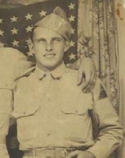


Daniel Jacob “Buck” Metzger II
| Birth | : | 15 Nov 1923 Alma, Harlan County, Nebraska, USA |
| Death | : | 4 Jun 1976 Cozad, Dawson County, Nebraska, USA |
| Burial | : | Oak Hill Cemetery, Washington, District of Columbia, USA |
| Coordinate | : | 38.9127998, -77.0567017 |
| Description | : | Daniel Metzger was born the 11th of 13 children; the first three being from his father's first wife who died young. He grew up on a farm near Alma and lost his father during the depression when he was 8 years old. He worked for the CCC for a time, then joined the army to serve in WWII from 1943 to 1946. He drove a tank and served in France and Germany. He was awarded two purple hearts. After the army he went to work for the Burlington Railroad and continued to do so until... Read More |
frequently asked questions (FAQ):
-
Where is Daniel Jacob “Buck” Metzger II's memorial?
Daniel Jacob “Buck” Metzger II's memorial is located at: Oak Hill Cemetery, Washington, District of Columbia, USA.
-
When did Daniel Jacob “Buck” Metzger II death?
Daniel Jacob “Buck” Metzger II death on 4 Jun 1976 in Cozad, Dawson County, Nebraska, USA
-
Where are the coordinates of the Daniel Jacob “Buck” Metzger II's memorial?
Latitude: 38.9127998
Longitude: -77.0567017
Family Members:
Parent

Spouse
Siblings
Children
Flowers:


Nearby Cemetories:
1. Oak Hill Cemetery
Washington, District of Columbia, USA
Coordinate: 38.9127998, -77.0567017
2. Mount Zion Cemetery
Washington, District of Columbia, USA
Coordinate: 38.9111200, -77.0546640
3. Female Union Band Society Cemetery
Washington, District of Columbia, USA
Coordinate: 38.9111940, -77.0540550
4. Kalorama Cemetery (Defunct)
Kalorama, District of Columbia, USA
Coordinate: 38.9130690, -77.0504020
5. Dumbarton Oaks Gardens
Washington, District of Columbia, USA
Coordinate: 38.9142000, -77.0628400
6. Georgetown Presbyterian Church Columbarium
Washington, District of Columbia, USA
Coordinate: 38.9095410, -77.0621590
7. Christ Church Georgetown Cemetery
Georgetown, District of Columbia, USA
Coordinate: 38.9083960, -77.0614930
8. Beall Burying Ground
Anacostia, District of Columbia, USA
Coordinate: 38.9070560, -77.0599774
9. Georgetown Lutheran Churchyard
Georgetown, District of Columbia, USA
Coordinate: 38.9099870, -77.0650500
10. Saint Margarets Episcopal Church Columbarium
Washington, District of Columbia, USA
Coordinate: 38.9150310, -77.0466510
11. Saint Johns Episcopal Church Columbarium
Georgetown, District of Columbia, USA
Coordinate: 38.9075200, -77.0649600
12. Old Presbyterian Cemetery
Georgetown, District of Columbia, USA
Coordinate: 38.9099998, -77.0671997
13. Holmeads Cemetery
Washington, District of Columbia, USA
Coordinate: 38.9143982, -77.0444031
14. Saint Pauls Episcopal Church Columbarium
Georgetown, District of Columbia, USA
Coordinate: 38.9023500, -77.0527000
15. Holy Rood Cemetery
Washington, District of Columbia, USA
Coordinate: 38.9174995, -77.0702972
16. Holy Trinity Church Cemetery (Defunct)
Georgetown, District of Columbia, USA
Coordinate: 38.9071730, -77.0699850
17. Georgetown Visitation Monastery Cemetery
Washington, District of Columbia, USA
Coordinate: 38.9094200, -77.0724600
18. Holy Trinity Cemetery #2
Georgetown, District of Columbia, USA
Coordinate: 38.9096390, -77.0733730
19. Mount Pleasant Plains Cemetery
Woodley Park, District of Columbia, USA
Coordinate: 38.9238520, -77.0458420
20. Georgetown University Jesuit Cemetery
Washington, District of Columbia, USA
Coordinate: 38.9083000, -77.0737200
21. Dahlgren Chapel of the Sacred Heart Crypt
Georgetown, District of Columbia, USA
Coordinate: 38.9072850, -77.0735950
22. Cathedral of Saint Matthew the Apostle
Washington, District of Columbia, USA
Coordinate: 38.9062520, -77.0402070
23. Foundry Methodist Church Columbarium
Washington, District of Columbia, USA
Coordinate: 38.9101240, -77.0369650
24. House of the Temple
Washington, District of Columbia, USA
Coordinate: 38.9138000, -77.0359000