
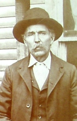
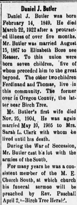

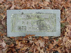
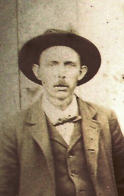
Daniel Jasper Butler
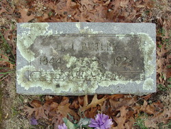
| Birth | : | 1844 Jackson County, Tennessee, USA |
| Death | : | 1922 Shannon County, Missouri, USA |
| Burial | : | Independent Chapel Churchyard, Blackburn, Blackburn with Darwen Unitary Authority, England |
| Coordinate | : | 53.7454960, -2.4864460 |
| Description | : | Birch Tree, Shannon County, Missouri Daniel was the son of Absalom Jason and Elizabeth Davis Butler. He was the first of seven children. When Daniel was about eleven years old his parents moved the family from Jackson County, Tennessee to Oregon County, Missouri. The seventh child was born here. Elizabeth died in 1863 and is buried somewhere in Oregon County. Daniel's father, Absalom married Mary Ann Underwood in 1864 and soon after the birth of their first child the family moved to Arkansas. By this time Daniel was grown and was ready to take... Read More |
frequently asked questions (FAQ):
-
Where is Daniel Jasper Butler's memorial?
Daniel Jasper Butler's memorial is located at: Independent Chapel Churchyard, Blackburn, Blackburn with Darwen Unitary Authority, England.
-
When did Daniel Jasper Butler death?
Daniel Jasper Butler death on 1922 in Shannon County, Missouri, USA
-
Where are the coordinates of the Daniel Jasper Butler's memorial?
Latitude: 53.7454960
Longitude: -2.4864460
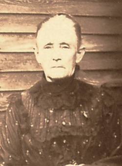
Family Members:
Spouse
Children


Nearby Cemetories:
1. Independent Chapel Churchyard
Blackburn, Blackburn with Darwen Unitary Authority, England
Coordinate: 53.7454960, -2.4864460
2. St. Peter's Churchyard
Blackburn, Blackburn with Darwen Unitary Authority, England
Coordinate: 53.7448110, -2.4865070
3. Wesleyan Methodist Chapel Chapelyard
Blackburn, Blackburn with Darwen Unitary Authority, England
Coordinate: 53.7464910, -2.4848380
4. Blackburn Cathedral
Blackburn, Blackburn with Darwen Unitary Authority, England
Coordinate: 53.7472960, -2.4820020
5. St Paul's
Blackburn, Blackburn with Darwen Unitary Authority, England
Coordinate: 53.7491222, -2.4891266
6. Mount St Presbyterian Chapelyard
Blackburn, Blackburn with Darwen Unitary Authority, England
Coordinate: 53.7478000, -2.4775000
7. Holy Trinity Church
Blackburn with Darwen Unitary Authority, England
Coordinate: 53.7511727, -2.4747178
8. St Alban's Churchyard
Blackburn, Blackburn with Darwen Unitary Authority, England
Coordinate: 53.7530090, -2.4748540
9. Blackburn Cemetery
Blackburn, Blackburn with Darwen Unitary Authority, England
Coordinate: 53.7662430, -2.4726050
10. St James Churchyard
Lower Darwen, Blackburn with Darwen Unitary Authority, England
Coordinate: 53.7245510, -2.4634700
11. New Row Methodist Church
Blackburn with Darwen Unitary Authority, England
Coordinate: 53.7208950, -2.5023720
12. Pleasington Cemetery and Crematorium
Blackburn, Blackburn with Darwen Unitary Authority, England
Coordinate: 53.7388880, -2.5368710
13. Pleasington Priory
Pleasington, Blackburn with Darwen Unitary Authority, England
Coordinate: 53.7348590, -2.5433060
14. Mellor Methodist Churchyard
Blackburn, Blackburn with Darwen Unitary Authority, England
Coordinate: 53.7742950, -2.5255060
15. St. Mary's Churchyard
Mellor, Ribble Valley Borough, England
Coordinate: 53.7728600, -2.5312400
16. St Stephen Churchyard
Tockholes, Blackburn with Darwen Unitary Authority, England
Coordinate: 53.7058350, -2.5169320
17. St Peter Churchyard
Salesbury, Ribble Valley Borough, England
Coordinate: 53.7915000, -2.4859100
18. St Mary's R.C. Church Cemetery
Osbaldeston, Ribble Valley Borough, England
Coordinate: 53.7816970, -2.5350240
19. New Lane Baptist Chapel Chapelyard
Oswaldwistle, Hyndburn Borough, England
Coordinate: 53.7381100, -2.4049500
20. Immanuel Churchyard
Oswaldwistle, Hyndburn Borough, England
Coordinate: 53.7358300, -2.4056200
21. St Peters Churchyard
Darwen, Blackburn with Darwen Unitary Authority, England
Coordinate: 53.6955520, -2.4648090
22. St James Churchyard
Church, Hyndburn Borough, England
Coordinate: 53.7574640, -2.3942660
23. Great Harwood Cemetery
Great Harwood, Hyndburn Borough, England
Coordinate: 53.7796190, -2.4091680
24. St. Paul's Churchyard
Darwen, Blackburn with Darwen Unitary Authority, England
Coordinate: 53.6979270, -2.4318640