
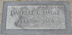
Darrell George Hagle
| Birth | : | 16 Nov 1948 Sharon, Steele County, North Dakota, USA |
| Death | : | 22 May 1969 |
| Burial | : | St. Mary's Churchyard, Brome, Mid Suffolk District, England |
| Coordinate | : | 52.3443800, 1.1475990 |
| Inscription | : | TEC 5 U. S. Army N. D. WWII |
| Description | : | The funeral for Darrell G. Hagle, 20, who was killed in a car accident here Thursday, will be here at 10:30 Monday in Trinity Lutheran Church. Burial will be at Binford, N.D. He was born at Sharon, N.D., Nov. 16, 1948, and was graduated from high school at Binford. He was presently employed in Cooperstown. He leaves his mother, Mrs. Donna Hagle, Casper, Wyo.; four sisters and a brother, Bonnie, Barbara, Beth, Dean and Beverly' a half-sister and a half-brother, Mary and David at Casper; and his grandparents, Mr. and Mrs. Henry Hagle and Mrs. Olga... Read More |
frequently asked questions (FAQ):
-
Where is Darrell George Hagle's memorial?
Darrell George Hagle's memorial is located at: St. Mary's Churchyard, Brome, Mid Suffolk District, England.
-
When did Darrell George Hagle death?
Darrell George Hagle death on 22 May 1969 in
-
Where are the coordinates of the Darrell George Hagle's memorial?
Latitude: 52.3443800
Longitude: 1.1475990
Family Members:
Parent
Siblings
Flowers:


Nearby Cemetories:
1. St. Mary's Churchyard
Brome, Mid Suffolk District, England
Coordinate: 52.3443800, 1.1475990
2. St. Nicholas Churchyard
Oakley, Mid Suffolk District, England
Coordinate: 52.3518380, 1.1662190
3. All Saints Churchyard
Stuston, Mid Suffolk District, England
Coordinate: 52.3571980, 1.1332590
4. Eye War Memorial
Eye, Mid Suffolk District, England
Coordinate: 52.3213410, 1.1461480
5. Saint Andrew Churchyard
Scole, South Norfolk District, England
Coordinate: 52.3671670, 1.1579150
6. Saint Peter and Saint Paul Churchyard
Eye, Mid Suffolk District, England
Coordinate: 52.3200520, 1.1516450
7. Eye Cemetery
Eye, Mid Suffolk District, England
Coordinate: 52.3188270, 1.1371000
8. St Leonard Churchyard
Billingford, South Norfolk District, England
Coordinate: 52.3666290, 1.1834260
9. St Peter Churchyard
Palgrave, Mid Suffolk District, England
Coordinate: 52.3634190, 1.1059170
10. Saint Peter and St. Paul Churchyard
Hoxne, Mid Suffolk District, England
Coordinate: 52.3522270, 1.2016300
11. Unitarian Chapel Cemetery
Palgrave, Mid Suffolk District, England
Coordinate: 52.3693130, 1.1086820
12. St Andrew's Frenze Church
Scole, South Norfolk District, England
Coordinate: 52.3802000, 1.1361000
13. Saint Mary Churchyard
Diss, South Norfolk District, England
Coordinate: 52.3772370, 1.1097880
14. Diss War Memorial
Diss, South Norfolk District, England
Coordinate: 52.3773380, 1.1088530
15. Saint John The Baptist Churchyard
Denham, Mid Suffolk District, England
Coordinate: 52.3275300, 1.2101200
16. Croft Lane Baptist Church Burial Ground
Diss, South Norfolk District, England
Coordinate: 52.3771070, 1.1025490
17. St Mary's Church Burial Ground - old
Braiseworth, Mid Suffolk District, England
Coordinate: 52.3028860, 1.1277010
18. Braiseworth War Memorial
Braiseworth, Mid Suffolk District, England
Coordinate: 52.3027890, 1.1276970
19. Diss Cemetery
Diss, South Norfolk District, England
Coordinate: 52.3839060, 1.1115880
20. St Mary Churchyard
Thornham Parva, Mid Suffolk District, England
Coordinate: 52.3113910, 1.0926010
21. St Mary the Virgin Churchyard
Mellis, Mid Suffolk District, England
Coordinate: 52.3268950, 1.0725720
22. St. Michael's Churchyard
Occold, Mid Suffolk District, England
Coordinate: 52.2936170, 1.1598150
23. St. Remigius Churchyard
Roydon, South Norfolk District, England
Coordinate: 52.3815610, 1.0784680
24. Saint George Churchyard
Shimpling, South Norfolk District, England
Coordinate: 52.3993000, 1.1680000