
| Birth | : | 25 Feb 1885 Van Horne, Benton County, Iowa, USA |
| Death | : | 27 Oct 1967 Manteca, San Joaquin County, California, USA |
| Burial | : | Park View Cemetery, Manteca, San Joaquin County, USA |
| Coordinate | : | 37.8617249, -121.2238312 |
| Plot | : | NN / 27/64/3 |
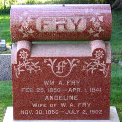
| Description | : | Death Certificate David Elmer Frey Father: William A. Frey, Iowa Mother: Angeline Wright, Wisconsin Widowed Dairy Farmer burial Park View Cemetery Oct 31, 1967 MANTECA, Oct, 28-David Elmer Frey, 82, of Highway 50, a Lathrop area resident some 45 years, died yesterday in a local hospital following a lengthy illness. Mr. Frey, a dairy farmer at Louise Avenue and Highway 50 some 37 years, sold part of his land in 1959 to Libby-Owens-Ford Glass Co., for the plant. He retired in 1959 and then worked about two years at Best Fertilizers Co. plant in Lathrop.... Read More |
frequently asked questions (FAQ):
-
Where is David Elmer Frey's memorial?
David Elmer Frey's memorial is located at: Park View Cemetery, Manteca, San Joaquin County, USA.
-
When did David Elmer Frey death?
David Elmer Frey death on 27 Oct 1967 in Manteca, San Joaquin County, California, USA
-
Where are the coordinates of the David Elmer Frey's memorial?
Latitude: 37.8617249
Longitude: -121.2238312
Family Members:
Parent

Spouse

Siblings
Children
Flowers:


Nearby Cemetories:
1. Congregation Adas Yeshuran of Stockton Cemetery
French Camp, San Joaquin County, USA
Coordinate: 37.8784065, -121.2740784
2. Congregation of Ahavas Achim Cemetery
French Camp, San Joaquin County, USA
Coordinate: 37.8778419, -121.2753067
3. Chinese Cemetery
French Camp, San Joaquin County, USA
Coordinate: 37.8819962, -121.2805862
4. East Union Cemetery
Manteca, San Joaquin County, USA
Coordinate: 37.8114014, -121.2350006
5. Atlanta Cemetery
Five Corners, San Joaquin County, USA
Coordinate: 37.8270035, -121.1420135
6. Collegeville Cemetery
Collegeville, San Joaquin County, USA
Coordinate: 37.9044800, -121.1466141
7. Citizens Cemetery
Stockton, San Joaquin County, USA
Coordinate: 37.9559410, -121.2769120
8. Thomas Lindsay Gravesite
San Joaquin County, USA
Coordinate: 37.9573110, -121.2918430
9. David Kelsey Gravesite
Stockton, San Joaquin County, USA
Coordinate: 37.9573110, -121.2918430
10. Temple Israel Cemetery
Stockton, San Joaquin County, USA
Coordinate: 37.9640541, -121.2784348
11. Stockton State Hospital Cemetery
Stockton, San Joaquin County, USA
Coordinate: 37.9663110, -121.2846850
12. San Joaquin Catholic Cemetery
Stockton, San Joaquin County, USA
Coordinate: 37.9707830, -121.2850190
13. Casa Bonita Mausoleum
Stockton, San Joaquin County, USA
Coordinate: 37.9752340, -121.2877800
14. Stockton Woodland Mausoleum
Stockton, San Joaquin County, USA
Coordinate: 37.9762400, -121.2878000
15. Stockton Rural Cemetery
Stockton, San Joaquin County, USA
Coordinate: 37.9794006, -121.2869034
16. Saint John's Catholic Cemetery
Escalon, San Joaquin County, USA
Coordinate: 37.7994537, -121.0705185
17. Central United Methodist Church Columbarium
Stockton, San Joaquin County, USA
Coordinate: 37.9825710, -121.3078170
18. Ripon Cemetery
Ripon, San Joaquin County, USA
Coordinate: 37.7420311, -121.1238708
19. Highland View Memorial Gardens
Farmington, San Joaquin County, USA
Coordinate: 37.9242935, -121.0008621
20. Linden Cemetery
Linden, San Joaquin County, USA
Coordinate: 38.0226707, -121.0889053
21. Tracy Mausoleum
Tracy, San Joaquin County, USA
Coordinate: 37.7250214, -121.4150696
22. Tracy Public Cemetery
Tracy, San Joaquin County, USA
Coordinate: 37.7251358, -121.4189453
23. Wood Colony Cemetery
Salida, Stanislaus County, USA
Coordinate: 37.6893730, -121.0682144
24. Good Shepherd Catholic Cemetery
Modesto, Stanislaus County, USA
Coordinate: 37.6853130, -121.0672890