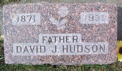
David Joseph Hudson
| Birth | : | 26 Nov 1871 Isabella, Delta County, Michigan, USA |
| Death | : | 16 Sep 1931 Stillwater County, Montana, USA |
| Burial | : | Lake Township Cemetery, Walbridge, Wood County, USA |
| Coordinate | : | 41.5892181, -83.4677124 |
| Description | : | The Billings Gazette (MT), 17 Sept 1931 Brain Injury Proves Fatal. Absarokee Rancher Was Unconscious for 79 Hours Fatally injured when his horse fell with him Sunday noon, David Hudson, well known Absarokee rancher, died in a hospital here Wednesday night without regaining consciousness for 79 hours after the accident. He had been a resident of the state since 1884 and for 42 years had lived in or near Absarokee. He was one of the first settlers in that section when reservation lands were thrown open in 1889, homesteading along the Stillwater with an older brother. Mr. Hudson later... Read More |
frequently asked questions (FAQ):
-
Where is David Joseph Hudson's memorial?
David Joseph Hudson's memorial is located at: Lake Township Cemetery, Walbridge, Wood County, USA.
-
When did David Joseph Hudson death?
David Joseph Hudson death on 16 Sep 1931 in Stillwater County, Montana, USA
-
Where are the coordinates of the David Joseph Hudson's memorial?
Latitude: 41.5892181
Longitude: -83.4677124
Family Members:
Spouse
Children
Flowers:
Nearby Cemetories:
1. Lake Township Cemetery
Walbridge, Wood County, USA
Coordinate: 41.5892181, -83.4677124
2. Hillabrand Cemetery
Oregon, Lucas County, USA
Coordinate: 41.6200530, -83.4256350
3. Willow Cemetery
Oregon, Lucas County, USA
Coordinate: 41.6292000, -83.4997025
4. Crane Creek Cemetery
Williston, Ottawa County, USA
Coordinate: 41.5802994, -83.3968964
5. Saint Johns Lutheran Church Cemetery
Toledo, Lucas County, USA
Coordinate: 41.6519920, -83.4897530
6. Unnamed Cemetery #4 (Defunct)
Toledo, Lucas County, USA
Coordinate: 41.6434540, -83.5252720
7. Beth Shalom Cemetery
Oregon, Lucas County, USA
Coordinate: 41.6603300, -83.4713200
8. North Oregon Cemetery
Oregon, Lucas County, USA
Coordinate: 41.6613998, -83.4705963
9. Restlawn Memorial Park
Perrysburg, Wood County, USA
Coordinate: 41.5133018, -83.4661026
10. Caswell Cemetery
Rossford, Wood County, USA
Coordinate: 41.6146180, -83.5672210
11. Trinity Episcopal Columbarium
Toledo, Lucas County, USA
Coordinate: 41.6527470, -83.5331560
12. Anshai Sfard Cemetery
Rossford, Wood County, USA
Coordinate: 41.6043700, -83.5736600
13. Saint Ignatius Cemetery
Oregon, Lucas County, USA
Coordinate: 41.6564369, -83.4079895
14. Toledo Hebrew Cemetery
Rossford, Wood County, USA
Coordinate: 41.6040550, -83.5741780
15. Unnamed Cemetery #1 (Defunct)
Toledo, Lucas County, USA
Coordinate: 41.6570280, -83.5463600
16. Unnamed Cemetery #3 (Defunct)
Toledo, Lucas County, USA
Coordinate: 41.6663240, -83.5334060
17. Forest Cemetery
Toledo, Lucas County, USA
Coordinate: 41.6693130, -83.5293320
18. Hufford Cemetery
Perrysburg, Wood County, USA
Coordinate: 41.5649986, -83.5896988
19. Saint Patricks Catholic Cemetery (Defunct)
Toledo, Lucas County, USA
Coordinate: 41.6376880, -83.5797440
20. Allen Township Cemetery
Williston, Ottawa County, USA
Coordinate: 41.6100006, -83.3396988
21. Saint Peters Cemetery (Defunct)
Toledo, Lucas County, USA
Coordinate: 41.6359700, -83.5843400
22. Oak Wood Cemetery
Curtice, Lucas County, USA
Coordinate: 41.6242590, -83.3420000
23. Sunshine Cemetery (Defunct)
Toledo, Lucas County, USA
Coordinate: 41.6192110, -83.5963720
24. Manhattan Cemetery
Toledo, Lucas County, USA
Coordinate: 41.6878117, -83.4964925


