
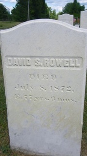
David Spaulding Rowell
| Birth | : | 9 Apr 1795 Madison, Somerset County, Maine, USA |
| Death | : | 8 Jul 1872 Madison, Somerset County, Maine, USA |
| Burial | : | Hillcrest Cemetery, Albert Lea, Freeborn County, USA |
| Coordinate | : | 43.6100006, -93.3343964 |
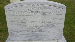
| Inscription | : | David S. Rowell Died July 8, 1872 ᴁ 77 yrs. 3 mos |
frequently asked questions (FAQ):
-
Where is David Spaulding Rowell's memorial?
David Spaulding Rowell's memorial is located at: Hillcrest Cemetery, Albert Lea, Freeborn County, USA.
-
When did David Spaulding Rowell death?
David Spaulding Rowell death on 8 Jul 1872 in Madison, Somerset County, Maine, USA
-
Where are the coordinates of the David Spaulding Rowell's memorial?
Latitude: 43.6100006
Longitude: -93.3343964
Family Members:
Parent
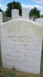
Spouse
Siblings
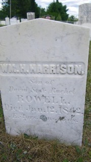
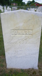
Children

Flowers:


Nearby Cemetories:
1. Hillcrest Cemetery
Albert Lea, Freeborn County, USA
Coordinate: 43.6100006, -93.3343964
2. Glenville First Lutheran Cemetery
Glenville, Freeborn County, USA
Coordinate: 43.6002808, -93.3088913
3. Green Cemetery
Twin Lakes, Freeborn County, USA
Coordinate: 43.5758743, -93.3619156
4. Lakewood Cemetery
Albert Lea, Freeborn County, USA
Coordinate: 43.6591682, -93.3694382
5. Saint Theodores Cemetery
Albert Lea, Freeborn County, USA
Coordinate: 43.6611099, -93.3705597
6. Lunder Lutheran Cemetery
Twin Lakes, Freeborn County, USA
Coordinate: 43.5750008, -93.3977814
7. Graceland Cemetery
Albert Lea, Freeborn County, USA
Coordinate: 43.6491699, -93.3930588
8. North Round Prairie Cemetery
Glenville, Freeborn County, USA
Coordinate: 43.5531006, -93.3649979
9. Greenwood Cemetery
Glenville, Freeborn County, USA
Coordinate: 43.5727997, -93.2675018
10. Round Prairie Cemetery
Glenville, Freeborn County, USA
Coordinate: 43.5411987, -93.3529968
11. Hayward Cemetery
Hayward, Freeborn County, USA
Coordinate: 43.6445618, -93.2436066
12. Shady Oak Cemetery
Conger, Freeborn County, USA
Coordinate: 43.6166687, -93.4452820
13. Itasca Cemetery
Albert Lea, Freeborn County, USA
Coordinate: 43.6758499, -93.4035721
14. Poor Farm Cemetery
Bancroft, Freeborn County, USA
Coordinate: 43.7013466, -93.3613213
15. East Freeborn Lutheran Church Cemetery
Lerdal, Freeborn County, USA
Coordinate: 43.7008286, -93.2991714
16. Saint James Cemetery
Twin Lakes, Freeborn County, USA
Coordinate: 43.5346985, -93.4178009
17. Central Freeborn Lutheran Cemetery
Albert Lea, Freeborn County, USA
Coordinate: 43.7088890, -93.3819427
18. Concordia Pickerel Lake Cemetery
Conger, Freeborn County, USA
Coordinate: 43.6300011, -93.4805603
19. Brush Hill Cemetery
Twin Lakes, Freeborn County, USA
Coordinate: 43.5491982, -93.4580994
20. Bear Lake Cemetery
Freeborn County, USA
Coordinate: 43.5787354, -93.4795990
21. Bohemian National Cemetery
Myrtle, Freeborn County, USA
Coordinate: 43.6152992, -93.1691971
22. Kestner Cemetery
Myrtle, Freeborn County, USA
Coordinate: 43.6083298, -93.1583328
23. Towne Cemetery
Northwood, Worth County, USA
Coordinate: 43.4805000, -93.3502000
24. Our Saviors Danish Lutheran Cemetery
Myrtle, Freeborn County, USA
Coordinate: 43.5580400, -93.1697300