
Deacon William Parker
| Birth | : | Jul 1645 Hartford, Hartford County, Connecticut, USA |
| Death | : | 20 Aug 1725 Saybrook Point, Middlesex County, Connecticut, USA |
| Burial | : | Blackley Cemetery and Crematorium, Blackley, Metropolitan Borough of Manchester, England |
| Coordinate | : | 53.5333176, -2.2394190 |
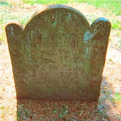
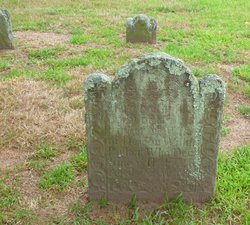
| Inscription | : | AE 81 years |
| Description | : | ~MY PARKER FAMILY~ Deacon William Parker was the son of my ancestors, WILLIAM & Margaret (Pritchard) Parker. He was a Deacon of the First Church of Saybrook. He was a commissioner to the General Court at Hartford from Saybrook. On Oct., 1695, the Court considered the last will and testament of Wm Parker, acknowledging that half of his land was given to his son, William Parker and a considerable amount of land was given to his brother, David Parker. The court concluded that the mansion house & land adjoining are not included in the estate of Deacon Wm Parker and... Read More |
frequently asked questions (FAQ):
-
Where is Deacon William Parker's memorial?
Deacon William Parker's memorial is located at: Blackley Cemetery and Crematorium, Blackley, Metropolitan Borough of Manchester, England.
-
When did Deacon William Parker death?
Deacon William Parker death on 20 Aug 1725 in Saybrook Point, Middlesex County, Connecticut, USA
-
Where are the coordinates of the Deacon William Parker's memorial?
Latitude: 53.5333176
Longitude: -2.2394190
Family Members:
Parent

Spouse
Siblings
Flowers:


Nearby Cemetories:
1. Blackley Cemetery and Crematorium
Blackley, Metropolitan Borough of Manchester, England
Coordinate: 53.5333176, -2.2394190
2. All Saints Churchyard Rhodes
Middleton, Metropolitan Borough of Rochdale, England
Coordinate: 53.5437200, -2.2261400
3. Blackley Presbyterian Chapel Chapelyard
Blackley, Metropolitan Borough of Manchester, England
Coordinate: 53.5233100, -2.2248110
4. St. Peter's Churchyard
Blackley, Metropolitan Borough of Manchester, England
Coordinate: 53.5231200, -2.2188900
5. Blackley Jewish Cemetery
Blackley, Metropolitan Borough of Manchester, England
Coordinate: 53.5299377, -2.2097650
6. Wesleyan Methodist Cemetery
Crumpsall, Metropolitan Borough of Manchester, England
Coordinate: 53.5142870, -2.2447610
7. Crumpsall Jewish Cemetery
Crumpsall, Metropolitan Borough of Manchester, England
Coordinate: 53.5124250, -2.2280270
8. St. Marks' Churchyard
Cheetham Hill, Metropolitan Borough of Manchester, England
Coordinate: 53.5113780, -2.2462660
9. Christchurch Harpurhey Churchyard
Harpurhey, Metropolitan Borough of Manchester, England
Coordinate: 53.5115100, -2.2134800
10. Great Synagogue Cemetery
Prestwich, Metropolitan Borough of Bury, England
Coordinate: 53.5315510, -2.2845730
11. St Paul's Churchyard
Salford, Metropolitan Borough of Salford, England
Coordinate: 53.5148800, -2.2725500
12. St. Mary the Virgin Churchyard
Prestwich, Metropolitan Borough of Bury, England
Coordinate: 53.5294033, -2.2864891
13. St Luke's Churchyard
Cheetham Hill, Metropolitan Borough of Manchester, England
Coordinate: 53.5041660, -2.2354680
14. Manchester General Cemetery
Manchester, Metropolitan Borough of Manchester, England
Coordinate: 53.5062710, -2.2179570
15. St. Michael's Churchyard
Middleton, Metropolitan Borough of Rochdale, England
Coordinate: 53.5476600, -2.1907240
16. Manchester Reform Jewish Old Cemetery
Whitefield, Metropolitan Borough of Bury, England
Coordinate: 53.5442728, -2.2918894
17. St Leonard's Churchyard
Middleton, Metropolitan Borough of Rochdale, England
Coordinate: 53.5530640, -2.1945060
18. Old Burial Grounds
Middleton, Metropolitan Borough of Rochdale, England
Coordinate: 53.5534036, -2.1948053
19. Rainsough Jewish Cemetery
Prestwich, Metropolitan Borough of Bury, England
Coordinate: 53.5185530, -2.2906950
20. St. Mary's Churchyard Birch-In-Hopwood
Heywood, Metropolitan Borough of Rochdale, England
Coordinate: 53.5662410, -2.2247560
21. St. Joseph's Roman Catholic Churchyard
Moston, Metropolitan Borough of Manchester, England
Coordinate: 53.5149270, -2.1877070
22. All Saints Churchyard Stand
Whitefield, Metropolitan Borough of Bury, England
Coordinate: 53.5501180, -2.2985570
23. Unsworth Weslyan Methodist Churchyard
Bury, Metropolitan Borough of Bury, England
Coordinate: 53.5667900, -2.2745100
24. St Georges Churchyard
Unsworth, Metropolitan Borough of Bury, England
Coordinate: 53.5668741, -2.2745340