
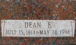
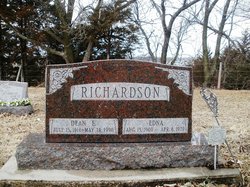
Dean Edward Richardson
| Birth | : | 15 Jul 1914 Burchard, Pawnee County, Nebraska, USA |
| Death | : | 14 May 1996 Pawnee City, Pawnee County, Nebraska, USA |
| Burial | : | Pawnee City Cemetery, Pawnee City, Pawnee County, USA |
| Coordinate | : | 40.1109009, -96.1608810 |
| Description | : | Beatrice Daily Sun(Beatrice, NE) Wednesday, 15 May 1996. Page 5 Dean Edward Richardson PAWNEE CITY -- Dean Edward Richardson, 81, Pawnee City, died Tuesday, May 14, 1996, at the Pawnee County Memorial Hospital, Pawnee City. He was born July 15, 1914, at Burchard and was a retired custodian for the U.S. Government. He was a member of the American Legion, the Veterans of Foreign Wars and IOOF Lodge, all of Pawnee City. Survivors: wife, Viola; daughters, Sarah Grubb and husband John and Shirley Richardson, all of Lincoln; stepson, LeRoy Kollar of Beatrice;... Read More |
frequently asked questions (FAQ):
-
Where is Dean Edward Richardson's memorial?
Dean Edward Richardson's memorial is located at: Pawnee City Cemetery, Pawnee City, Pawnee County, USA.
-
When did Dean Edward Richardson death?
Dean Edward Richardson death on 14 May 1996 in Pawnee City, Pawnee County, Nebraska, USA
-
Where are the coordinates of the Dean Edward Richardson's memorial?
Latitude: 40.1109009
Longitude: -96.1608810
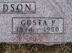
Family Members:
Parent
Spouse
Flowers:


Nearby Cemetories:
1. Pawnee City Cemetery
Pawnee City, Pawnee County, USA
Coordinate: 40.1109009, -96.1608810
2. East Amish Cemetery
Table Rock, Pawnee County, USA
Coordinate: 40.1310000, -96.0854000
3. Evergreen Cemetery
Pawnee County, USA
Coordinate: 40.0485992, -96.1417007
4. Pleasant Valley Cemetery
Pawnee County, USA
Coordinate: 40.0299988, -96.1554794
5. Table Rock Cemetery
Table Rock, Pawnee County, USA
Coordinate: 40.1791400, -96.1037400
6. Prairie Star Pioneer Cemetery
Du Bois, Pawnee County, USA
Coordinate: 40.0293000, -96.1041000
7. Beranek Cemetery
Table Rock, Pawnee County, USA
Coordinate: 40.2042007, -96.1607971
8. Pleasant Ridge Cemetery
Du Bois, Pawnee County, USA
Coordinate: 40.0156000, -96.1494000
9. West Branch Cemetery
Pawnee County, USA
Coordinate: 40.0787940, -96.2797160
10. Saint Anthonys Cemetery
Steinauer, Pawnee County, USA
Coordinate: 40.2075005, -96.2189026
11. Johnson Creek Cemetery
Pawnee City, Pawnee County, USA
Coordinate: 40.0270000, -96.2465000
12. Clear Creek Cemetery
Table Rock, Pawnee County, USA
Coordinate: 40.2193985, -96.1391983
13. Bohemian Cemetery
Table Rock, Pawnee County, USA
Coordinate: 40.1786003, -96.0374985
14. Saint Peters Evangelican Cemetery
Du Bois, Pawnee County, USA
Coordinate: 40.0010000, -96.1095000
15. Dry Branch Pioneer Cemetery
Richardson County, USA
Coordinate: 40.1292000, -96.0100021
16. DuBois Cemetery
Du Bois, Pawnee County, USA
Coordinate: 40.0231018, -96.0488968
17. Bohemian Cemetery
Richardson County, USA
Coordinate: 40.1175003, -95.9955978
18. Saint Johns Cemetery
Table Rock, Pawnee County, USA
Coordinate: 40.2148000, -96.0657000
19. Salems Cemetery
Steinauer, Pawnee County, USA
Coordinate: 40.2166000, -96.2555000
20. McCaffrey Cemetery
Nemaha County, USA
Coordinate: 39.9827100, -96.1474500
21. Madden Cemetery
Axtell, Marshall County, USA
Coordinate: 39.9866800, -96.2490300
22. Friedens United Church of Christ Cemetery
Bern, Nemaha County, USA
Coordinate: 39.9929008, -96.0529480
23. Saint Peters Lutheran Church Cemetery
Steinauer, Pawnee County, USA
Coordinate: 40.2555000, -96.1801000
24. Cincinnati Cemetery
Du Bois, Pawnee County, USA
Coordinate: 40.0042000, -96.0274963