
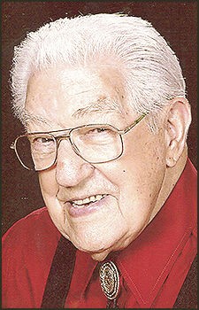
Delber William “Del” Copeland
| Birth | : | 23 Jan 1928 Idana, Clay County, Kansas, USA |
| Death | : | 15 Jul 2017 Pueblo, Pueblo County, Colorado, USA |
| Burial | : | Fort Lyon National Cemetery, Fort Lyon, Bent County, USA |
| Coordinate | : | 38.0847015, -103.1288986 |
| Plot | : | Section J, Row 14, Site A |
| Inscription | : | F1 US NAVY WORLD WAR II |
| Description | : | DELBER WILLIAM "DEL" COPELAND F1 US NAVY WWII January 23, 1928 - July 15, 2017 PUBLISHED in Pueblo Chieftain, Pueblo, Colorado, Sunday, July 30, 2017: Copeland, Delber William "Del" Delber William "Del" Copeland, 89, passed away July 15, 2017. He was born in Idana, Kan., to Beattie and Effie (McMahan) Copeland on Jan. 23, 1928. He was preceded in death by his parents; brothers, Joe and Don; and sisters, Edna Hatfield, Mary Goodin and Viola Oberhelman; grandchildren, John and Elizabeth Ferris; and mother of his children, Betty Copeland. He is survived by... Read More |
frequently asked questions (FAQ):
-
Where is Delber William “Del” Copeland's memorial?
Delber William “Del” Copeland's memorial is located at: Fort Lyon National Cemetery, Fort Lyon, Bent County, USA.
-
When did Delber William “Del” Copeland death?
Delber William “Del” Copeland death on 15 Jul 2017 in Pueblo, Pueblo County, Colorado, USA
-
Where are the coordinates of the Delber William “Del” Copeland's memorial?
Latitude: 38.0847015
Longitude: -103.1288986
Family Members:
Parent

Siblings
Children
Flowers:


Nearby Cemetories:
1. Fort Lyon National Cemetery
Fort Lyon, Bent County, USA
Coordinate: 38.0847015, -103.1288986
2. Fort Lyon Post Cemetery
Bent County, USA
Coordinate: 38.0427000, -103.0757000
3. Boggsville National Historic Site Grounds
Boggsville, Bent County, USA
Coordinate: 38.0425130, -103.2102730
4. Las Animas Cemetery
Las Animas, Bent County, USA
Coordinate: 38.0424995, -103.2174988
5. Union Valley Cemetery
Hasty, Bent County, USA
Coordinate: 38.0960999, -102.9574966
6. Indian Rock Cemetery
Bent County, USA
Coordinate: 37.9550018, -102.9630966
7. Home Cemetery
McClave, Bent County, USA
Coordinate: 38.1218987, -102.8497009
8. Bents Old Fort Cemetery
La Junta, Otero County, USA
Coordinate: 38.0416000, -103.4297000
9. Saint Paul’s Lutheran Cemetery
Otero County, USA
Coordinate: 38.0342000, -103.4542000
10. East Holbrook Mennonite Cemetery
Cheraw, Otero County, USA
Coordinate: 38.1101837, -103.4729767
11. Little Kansas Cemetery
Bent County, USA
Coordinate: 37.9399986, -102.8274994
12. Arlington Cemetery
Arlington, Kiowa County, USA
Coordinate: 38.3232994, -103.3597031
13. Hight Cemetery
Bent County, USA
Coordinate: 38.0264015, -102.7508011
14. Wiley Cemetery
Bent County, USA
Coordinate: 38.1688995, -102.7422028
15. Bethel Cemetery
Bent County, USA
Coordinate: 37.7888985, -102.9664001
16. Holbrook Cemetery
Otero County, USA
Coordinate: 38.0842018, -103.5432968
17. Saint Andrews Episcopal Church Columbarium
La Junta, Otero County, USA
Coordinate: 37.9809000, -103.5455000
18. Fairview Cemetery
La Junta, Otero County, USA
Coordinate: 37.9873000, -103.5607000
19. Calvary Cemetery
La Junta, Otero County, USA
Coordinate: 37.9832000, -103.5622000
20. Haswell Cemetery
Haswell, Kiowa County, USA
Coordinate: 38.4472000, -103.1726000
21. Ormega Cemetery
La Junta, Otero County, USA
Coordinate: 37.9684000, -103.5770000
22. Crawford Cemetery
Prowers County, USA
Coordinate: 38.1239014, -102.6585999
23. Pruett Cemetery
Bent County, USA
Coordinate: 37.7172012, -103.2897034
24. Riverside Cemetery
Lamar, Prowers County, USA
Coordinate: 38.0932999, -102.6072006