
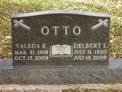
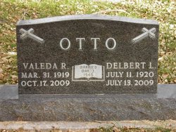
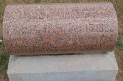
Delbert Lawrence Otto
| Birth | : | 11 Jul 1920 Pierce County, Nebraska, USA |
| Death | : | 13 Jul 2009 Norfolk, Madison County, Nebraska, USA |
| Burial | : | Hickory Grove Methodist Church Cemetery, Albright Township, Chatham County, USA |
| Coordinate | : | 35.8407560, -79.5217650 |
| Plot | : | Block 19 Lot 5 Grave 248 |
frequently asked questions (FAQ):
-
Where is Delbert Lawrence Otto's memorial?
Delbert Lawrence Otto's memorial is located at: Hickory Grove Methodist Church Cemetery, Albright Township, Chatham County, USA.
-
When did Delbert Lawrence Otto death?
Delbert Lawrence Otto death on 13 Jul 2009 in Norfolk, Madison County, Nebraska, USA
-
Where are the coordinates of the Delbert Lawrence Otto's memorial?
Latitude: 35.8407560
Longitude: -79.5217650
Family Members:
Parent

Spouse
Siblings

Flowers:


Nearby Cemetories:
1. Hickory Grove Methodist Church Cemetery
Albright Township, Chatham County, USA
Coordinate: 35.8407560, -79.5217650
2. Rocky River Baptist Church Cemetery
Crutchfield Crossroads, Chatham County, USA
Coordinate: 35.8222237, -79.4875031
3. Flint Ridge Church Cemetery
Chatham County, USA
Coordinate: 35.8427220, -79.4718840
4. Pleasant Union Pilgrim Holiness Church Cemetery
Snow Camp, Alamance County, USA
Coordinate: 35.8781350, -79.5011080
5. Pleasant Hill Christian Church Cemetery
Pleasant Hill, Alamance County, USA
Coordinate: 35.8725000, -79.4827000
6. Fairview Cemetery
Liberty, Randolph County, USA
Coordinate: 35.8516998, -79.5761032
7. Margarets Chapel Church Cemetery
Staley, Randolph County, USA
Coordinate: 35.8110940, -79.5648900
8. Olivers Chapel Cemetery
Staley, Randolph County, USA
Coordinate: 35.8060989, -79.5610962
9. Oak Grove Baptist Church Cemetery
Snow Camp, Alamance County, USA
Coordinate: 35.8873490, -79.5330180
10. Liberty Grove Methodist Church Cemetery
Liberty, Randolph County, USA
Coordinate: 35.8733140, -79.5709950
11. Mount Pleasant Baptist Church Cemetery
Staley, Randolph County, USA
Coordinate: 35.8144700, -79.5790000
12. Staley City Cemetery
Staley, Randolph County, USA
Coordinate: 35.7918300, -79.5507100
13. Amos Grove Cemetery
Liberty, Randolph County, USA
Coordinate: 35.8546982, -79.5871964
14. Saint Stephen Memorial Gardens
Liberty, Randolph County, USA
Coordinate: 35.8550750, -79.5877970
15. Bethany United Methodist Church Cemetery #2
Liberty, Randolph County, USA
Coordinate: 35.8430060, -79.5948160
16. Richland Cemetery
Liberty, Randolph County, USA
Coordinate: 35.8996315, -79.5469894
17. Lineberry Family Cemetery
Staley, Randolph County, USA
Coordinate: 35.7878000, -79.5724000
18. Old Shady Grove Cemetery
Staley, Randolph County, USA
Coordinate: 35.7874985, -79.5725021
19. Terry Family Cemetery
Crutchfield Crossroads, Chatham County, USA
Coordinate: 35.8231410, -79.4379040
20. McMasters Cemetery
Randolph County, USA
Coordinate: 35.8072370, -79.6021500
21. Shady Grove Baptist Church Cemetery
Staley, Randolph County, USA
Coordinate: 35.7853800, -79.5821020
22. Smithwood United Church of Christ Cemetery
Guilford County, USA
Coordinate: 35.9113900, -79.5605600
23. Cane Creek Monthly Meeting Cemetery
Snow Camp, Alamance County, USA
Coordinate: 35.8894005, -79.4458008
24. Bethlehem Wesleyan Church Cemetery
Snow Camp, Alamance County, USA
Coordinate: 35.8567660, -79.4266570