
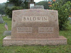
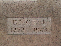
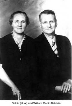

Delsia “Delcie” Hunt Baldwin
| Birth | : | 23 Oct 1878 Kitts Hill, Lawrence County, Ohio, USA |
| Death | : | 10 Jan 1945 Kitts Hill, Lawrence County, Ohio, USA |
| Burial | : | St. Lawrence's Churchyard, Fulstow, East Lindsey District, England |
| Coordinate | : | 53.4599000, -0.0070000 |
| Description | : | When Delsia "Delcie" Hunt was born on October 23, 1878, in Aid, Ohio, her father, Anderson Hunt III, was 58, and her mother, Rachel Justice, was 29. She married William Martin Baldwin on February 15, 1898, in Lawrence, Ohio. They had eight children in 20 years. She died on January 10, 1945, in Kitts Hill, Ohio, at the age of 66, and was buried there. Delsia had two brothers: Carlis Hunt (1876-Abt. 1900) and Fred Hunt (1881-1945). She had about 14 half-brothers and sisters. Father: Anderson Hunt 1821–1905 BIRTH MAR 1821 • Monroe County, West Virginia, USA DEATH... Read More |
frequently asked questions (FAQ):
-
Where is Delsia “Delcie” Hunt Baldwin's memorial?
Delsia “Delcie” Hunt Baldwin's memorial is located at: St. Lawrence's Churchyard, Fulstow, East Lindsey District, England.
-
When did Delsia “Delcie” Hunt Baldwin death?
Delsia “Delcie” Hunt Baldwin death on 10 Jan 1945 in Kitts Hill, Lawrence County, Ohio, USA
-
Where are the coordinates of the Delsia “Delcie” Hunt Baldwin's memorial?
Latitude: 53.4599000
Longitude: -0.0070000
Family Members:
Parent
Spouse

Siblings

Children
Flowers:


Nearby Cemetories:
1. St. Lawrence's Churchyard
Fulstow, East Lindsey District, England
Coordinate: 53.4599000, -0.0070000
2. St Bartholomew Churchyard
Covenham St Bartholomew, East Lindsey District, England
Coordinate: 53.4307280, 0.0140490
3. St Marys Churchyard
Ludborough, East Lindsey District, England
Coordinate: 53.4405106, -0.0510651
4. St. Mary’s Churchyard
Covenham St Mary, East Lindsey District, England
Coordinate: 53.4292484, 0.0147001
5. St Nicholas Church
Grainsby, East Lindsey District, England
Coordinate: 53.4765150, -0.0755630
6. St. Mary Churchyard
Fotherby, East Lindsey District, England
Coordinate: 53.4057520, -0.0204600
7. St Peters Churchyard
Holton le Clay, East Lindsey District, England
Coordinate: 53.5060368, -0.0616628
8. Holton le Clay Cemetery
Holton le Clay, East Lindsey District, England
Coordinate: 53.5074170, -0.0592630
9. St Edith's Churchyard
Little Grimsby, East Lindsey District, England
Coordinate: 53.4020500, -0.0062550
10. St. Clement's Churchyard
Grainthorpe, East Lindsey District, England
Coordinate: 53.4477210, 0.0881160
11. St Peters Churchyard
Humberston, North East Lincolnshire Unitary Authority, England
Coordinate: 53.5278300, -0.0238300
12. St Peter's Churchyard
Ashby cum Fenby, North East Lincolnshire Unitary Authority, England
Coordinate: 53.4903100, -0.1105200
13. St Adelwold Churchyard
Alvingham, East Lindsey District, England
Coordinate: 53.4009600, 0.0560600
14. St Helen's Churchyard
Brigsley, North East Lincolnshire Unitary Authority, England
Coordinate: 53.4982361, -0.1099315
15. St. Peter's Churchyard
Conisholme, East Lindsey District, England
Coordinate: 53.4365000, 0.1100100
16. Waltham Cemetery
Waltham, North East Lincolnshire Unitary Authority, England
Coordinate: 53.5155500, -0.0934700
17. All Saints Churchyard
Waltham, North East Lincolnshire Unitary Authority, England
Coordinate: 53.5167000, -0.0986700
18. St. Martin Churchyard
East Ravendale, North East Lincolnshire Unitary Authority, England
Coordinate: 53.4793000, -0.1370044
19. St. Margaret Churchyard
Keddington, East Lindsey District, England
Coordinate: 53.3777150, 0.0203370
20. Holy Trinity Church Cemetery
Louth, East Lindsey District, England
Coordinate: 53.3691600, 0.0071900
21. Saint Mary's Old Cemetery
Louth, East Lindsey District, England
Coordinate: 53.3679040, -0.0100780
22. Priory Cottage, Eastgate
Louth, East Lindsey District, England
Coordinate: 53.3679743, 0.0029732
23. St. Giles Churchyard
Scartho, North East Lincolnshire Unitary Authority, England
Coordinate: 53.5384200, -0.0888130
24. Louth Abbey
Louth, East Lindsey District, England
Coordinate: 53.3666840, -0.0080750