
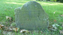
Desire Chipman Bourne
| Birth | : | 26 Feb 1674 Barnstable, Barnstable County, Massachusetts, USA |
| Death | : | 28 Mar 1705 Sandwich, Barnstable County, Massachusetts, USA |
| Burial | : | Mount Auburn Cemetery, Mount Auburn, Benton County, USA |
| Coordinate | : | 42.2536800, -92.0903000 |
| Description | : | Desire was born to John and Hope (Howland) Chipman in Barnstable in 1674. Her mother was the daughter of Mayflower passengers, John Howland and Elizabeth Tilley. At the age of 18, Desire married Melatiah Bourne and the marriage is recorded to have been officiated by Stephen Skiffe, Esq., Justice of the Peace, on the 23rd day of Feb Anno Domini 1692. They made their residence in Sandwich, where they had eight children before her death at the age of 31 years. Desire and Melatiah's children were: 1. Silvanus Bourne (1694–1763), m. Mercy Gorham. 2. Capt. Richard Bourne (1695–1738), m. Margaret Foster. 3. Samuel Bourne... Read More |
frequently asked questions (FAQ):
-
Where is Desire Chipman Bourne's memorial?
Desire Chipman Bourne's memorial is located at: Mount Auburn Cemetery, Mount Auburn, Benton County, USA.
-
When did Desire Chipman Bourne death?
Desire Chipman Bourne death on 28 Mar 1705 in Sandwich, Barnstable County, Massachusetts, USA
-
Where are the coordinates of the Desire Chipman Bourne's memorial?
Latitude: 42.2536800
Longitude: -92.0903000
Family Members:
Parent

Spouse
Siblings
Children
Flowers:


Nearby Cemetories:
1. Mount Auburn Cemetery
Mount Auburn, Benton County, USA
Coordinate: 42.2536800, -92.0903000
2. Greenwalt Cemetery
Mount Auburn, Benton County, USA
Coordinate: 42.2256012, -92.1038971
3. Engledow Cemetery
Mount Auburn, Benton County, USA
Coordinate: 42.2686996, -92.1330032
4. Pratt Creek Cemetery
Vinton, Benton County, USA
Coordinate: 42.2104000, -92.1307400
5. Westview Cemetery
La Porte City, Black Hawk County, USA
Coordinate: 42.3107986, -92.1699982
6. Bear Creek Cemetery
Benton County, USA
Coordinate: 42.2705994, -91.9792023
7. Carlisle Grove Cemetery
Garrison, Benton County, USA
Coordinate: 42.1730995, -92.1386032
8. Maplewood Cemetery
Vinton, Benton County, USA
Coordinate: 42.1699982, -92.0490036
9. Beachler Cemetery
Brandon, Buchanan County, USA
Coordinate: 42.3045000, -91.9908000
10. Fairview Cemetery
Benton County, USA
Coordinate: 42.2141991, -92.2007980
11. Saint Marys Cemetery
Vinton, Benton County, USA
Coordinate: 42.1683006, -92.0475006
12. Pettit Hill Cemetery
Vinton, Benton County, USA
Coordinate: 42.1916900, -91.9974000
13. Jefferson Township Cemetery
Brandon, Buchanan County, USA
Coordinate: 42.3139000, -91.9931030
14. Brandon Cemetery
Brandon, Buchanan County, USA
Coordinate: 42.3156300, -91.9945200
15. Sawyer Cemetery
La Porte City, Black Hawk County, USA
Coordinate: 42.3381004, -92.1519012
16. Spring Creek Chapel Cemetery
La Porte City, Black Hawk County, USA
Coordinate: 42.3616982, -92.0783005
17. Greenwood Cemetery
Brandon, Buchanan County, USA
Coordinate: 42.3123970, -91.9651640
18. Evergreen Cemetery
Vinton, Benton County, USA
Coordinate: 42.1610985, -92.0089035
19. Garrison Cemetery
Garrison, Benton County, USA
Coordinate: 42.1369019, -92.1483002
20. Shady Grove Cemetery
Jesup, Buchanan County, USA
Coordinate: 42.3805453, -92.0557342
21. Zion Lutheran Jubilee Cemetery
Jubilee, Black Hawk County, USA
Coordinate: 42.3843050, -92.0837440
22. Urmy Cemetery
Benton County, USA
Coordinate: 42.1719017, -92.2281036
23. Anton Cemetery
La Porte City, Black Hawk County, USA
Coordinate: 42.3418999, -92.2399979
24. Rampton Cemetery
Monroe Township, Benton County, USA
Coordinate: 42.1866989, -92.2605972