Dinney Driver
| Birth | : | 10 Jan 1857 Aurora, Madison County, Arkansas, USA |
| Death | : | 8 Jun 1871 Aurora, Madison County, Arkansas, USA |
| Burial | : | Riverview Cemetery, Port Clinton, Ottawa County, USA |
| Coordinate | : | 41.5097008, -82.9599991 |
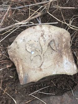
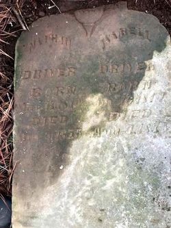
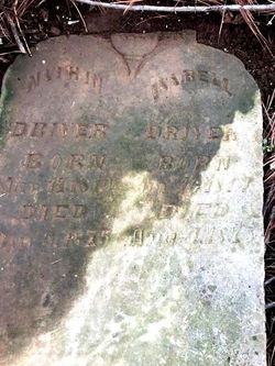
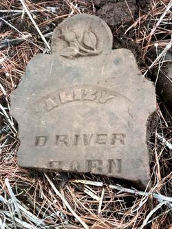
| Description | : | Daughter of Nathan and Isabelle GOAD Driver The 1860 census shows her as 4 years of age and she's listed as an idiot; in the 1870 census she is listed as insane. Her tombstone has been broken and only the top 1/4 of it could be found in January 2021, so the dates could not be confirmed. See picture posted here of the top 1/4 of the tombstone that we found. |
frequently asked questions (FAQ):
-
Where is Dinney Driver's memorial?
Dinney Driver's memorial is located at: Riverview Cemetery, Port Clinton, Ottawa County, USA.
-
When did Dinney Driver death?
Dinney Driver death on 8 Jun 1871 in Aurora, Madison County, Arkansas, USA
-
Where are the coordinates of the Dinney Driver's memorial?
Latitude: 41.5097008
Longitude: -82.9599991
Family Members:
Parent
Siblings
Flowers:
Nearby Cemetories:
1. Riverview Cemetery
Port Clinton, Ottawa County, USA
Coordinate: 41.5097008, -82.9599991
2. Lakeview Cemetery
Port Clinton, Ottawa County, USA
Coordinate: 41.5107994, -82.9511032
3. Saint Thomas Episcopal Columbarium
Port Clinton, Ottawa County, USA
Coordinate: 41.5118670, -82.9386350
4. Christy Chapel Cemetery
Gypsum, Ottawa County, USA
Coordinate: 41.5085983, -82.8861008
5. Camp Perry Memorial
Port Clinton, Ottawa County, USA
Coordinate: 41.5437850, -83.0193580
6. Tynan Burial Plot
Portage Township, Ottawa County, USA
Coordinate: 41.4909000, -82.8835000
7. LaCarpe Cemetery
Lacarne, Ottawa County, USA
Coordinate: 41.5368996, -83.0344009
8. Shook Cemetery
Portage Township, Ottawa County, USA
Coordinate: 41.5214005, -82.8758011
9. Dwelle Cemetery
Port Clinton, Ottawa County, USA
Coordinate: 41.5069008, -82.8563995
10. Hineline Cemetery
Port Clinton, Ottawa County, USA
Coordinate: 41.4634094, -83.0488739
11. K'Burg Family Cemetery
Catawba Island Township, Ottawa County, USA
Coordinate: 41.5589400, -82.8463000
12. County Home Cemetery
Oak Harbor, Ottawa County, USA
Coordinate: 41.5084650, -83.0929680
13. Catawba Island Cemetery
Catawba Island, Ottawa County, USA
Coordinate: 41.5569000, -82.8403015
14. Jamison Cemetery
Danbury, Ottawa County, USA
Coordinate: 41.5050060, -82.8180740
15. Rusha Cemetery
Oak Harbor, Ottawa County, USA
Coordinate: 41.5690994, -83.0865021
16. Lockwood Cemetery
Lakeside, Ottawa County, USA
Coordinate: 41.5435140, -82.8161560
17. Green Creek Burial Ground
Green Creek, Sandusky County, USA
Coordinate: 41.4046160, -83.0213860
18. LaPrairie Cemetery
Fremont, Sandusky County, USA
Coordinate: 41.4258030, -83.0669190
19. Saint Pauls Lutheran Church Cemetery
Lakeside, Ottawa County, USA
Coordinate: 41.5242200, -82.8049100
20. McCreery Farm Cemetery
Vickery, Sandusky County, USA
Coordinate: 41.3917594, -82.9823677
21. Lathrop Cemetery
Riley Township, Sandusky County, USA
Coordinate: 41.3928301, -83.0110269
22. Roose Cemetery
Oak Harbor, Ottawa County, USA
Coordinate: 41.4944000, -83.1268997
23. Sackett Cemetery
Danbury, Ottawa County, USA
Coordinate: 41.5303001, -82.7872009
24. Greenwood Cemetery
Kingsway, Sandusky County, USA
Coordinate: 41.4281100, -83.1060300

