
Donald Adelbert Curry
| Birth | : | 25 Nov 1918 Red Bluff, Tehama County, California, USA |
| Death | : | 12 Mar 1991 Wayne County, West Virginia, USA |
| Burial | : | Saint Andrew the Apostle, Holt, North Norfolk District, England |
| Coordinate | : | 52.9063400, 1.0933500 |
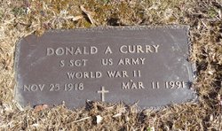
| Inscription | : | DONALD A CURRY S SGT US ARMY WORLD WAR II NOV 25 1918 MAR 11 1991 |
| Description | : | Donald was the son of Frank Curry & Mildred Eaton. He was a veteran of the Army Air Corps., World War II. Donald was a trumpet player and played lead trumpet in several of the Big Bands. He was married to Alma Maye Yoho. |
frequently asked questions (FAQ):
-
Where is Donald Adelbert Curry's memorial?
Donald Adelbert Curry's memorial is located at: Saint Andrew the Apostle, Holt, North Norfolk District, England.
-
When did Donald Adelbert Curry death?
Donald Adelbert Curry death on 12 Mar 1991 in Wayne County, West Virginia, USA
-
Where are the coordinates of the Donald Adelbert Curry's memorial?
Latitude: 52.9063400
Longitude: 1.0933500
Family Members:
Parent

Spouse
Flowers:


Nearby Cemetories:
1. Saint Andrew the Apostle
Holt, North Norfolk District, England
Coordinate: 52.9063400, 1.0933500
2. Methodist Memorial Gardens
Holt, North Norfolk District, England
Coordinate: 52.9067730, 1.0878360
3. Holt Town Cemetery
Holt, North Norfolk District, England
Coordinate: 52.9117900, 1.0850400
4. St. Andrews Churchyard
Letheringsett, North Norfolk District, England
Coordinate: 52.9081600, 1.0623490
5. St Andrew Churchyard
Hempstead, North Norfolk District, England
Coordinate: 52.8895750, 1.1270070
6. All Saints Churchyard
Hempstead, North Norfolk District, England
Coordinate: 52.8895200, 1.1274620
7. St. Mary the Virgin Churchyard
Kelling, North Norfolk District, England
Coordinate: 52.9322300, 1.1053700
8. St Lawrence Churchyard
Hunworth, North Norfolk District, England
Coordinate: 52.8772530, 1.0673080
9. Edgefield Old Churchyard
Edgefield, North Norfolk District, England
Coordinate: 52.8687300, 1.1001800
10. All Saints Churchyard
Bodham, North Norfolk District, England
Coordinate: 52.9057700, 1.1596200
11. St. Martin's Churchyard, Glandford
Letheringsett, North Norfolk District, England
Coordinate: 52.9311970, 1.0396308
12. St. Peter and St. Paul's Churchyard
Edgefield, North Norfolk District, England
Coordinate: 52.8645320, 1.1089840
13. St Nicholas Churchyard
Salthouse, North Norfolk District, England
Coordinate: 52.9503200, 1.0889800
14. Saint Mary's Churchyard
Baconsthorpe, North Norfolk District, England
Coordinate: 52.8872500, 1.1606900
15. St. Andrew's Churchyard
Brinton, North Norfolk District, England
Coordinate: 52.8803690, 1.0274610
16. St Margaret Churchyard
Cley, North Norfolk District, England
Coordinate: 52.9463890, 1.0475480
17. St. Margaret's Churchyard
Saxlingham, North Norfolk District, England
Coordinate: 52.9155250, 1.0121410
18. St Maurice Churchyard
Briningham, North Norfolk District, England
Coordinate: 52.8682680, 1.0271340
19. St. Michael's Churchyard
Plumstead, North Norfolk District, England
Coordinate: 52.8691700, 1.1669320
20. St Mary Churchyard Burgh Parva
Melton Constable, North Norfolk District, England
Coordinate: 52.8605700, 1.0337300
21. All Saints Churchyard
Briston, North Norfolk District, England
Coordinate: 52.8511120, 1.0617870
22. St. Nicholas' Churchyard
Blakeney, North Norfolk District, England
Coordinate: 52.9512300, 1.0247250
23. St. Peter's Churchyard
North Barningham, North Norfolk District, England
Coordinate: 52.8888040, 1.1954330
24. Carmelite Friary of the Blessed Virgin
Blakeney, North Norfolk District, England
Coordinate: 52.9553240, 1.0234250