
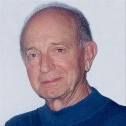
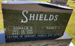
Donald E. “Don” Shields
| Birth | : | 14 Dec 1929 Logan, Harrison County, Iowa, USA |
| Death | : | 28 Mar 2018 Cedar Rapids, Linn County, Iowa, USA |
| Burial | : | Rowley Cemetery, Rowley, Buchanan County, USA |
| Coordinate | : | 42.3716621, -91.8530655 |
| Description | : | Donald E. Shields died Friday, March 23, 2018. Don was born on December 14, 1929, in Logan, IA, son of Edward J. and Doris E. (Brownell) Shields. He grew up in Missouri Valley, Logan, Omaha, and Persia, graduating from Persia High School in 1947, University of Iowa in 1951, and the School of Banking. Don began working at Rowley Savings Bank, Rowley, IA in 1951, and was Chairman of the Board at the time of his death. He was a member of the Iowa Bankers Association. Don is survived by his wife, Nancy, his children, Greg... Read More |
frequently asked questions (FAQ):
-
Where is Donald E. “Don” Shields's memorial?
Donald E. “Don” Shields's memorial is located at: Rowley Cemetery, Rowley, Buchanan County, USA.
-
When did Donald E. “Don” Shields death?
Donald E. “Don” Shields death on 28 Mar 2018 in Cedar Rapids, Linn County, Iowa, USA
-
Where are the coordinates of the Donald E. “Don” Shields's memorial?
Latitude: 42.3716621
Longitude: -91.8530655
Family Members:
Parent

Siblings


Nearby Cemetories:
1. Rowley Cemetery
Rowley, Buchanan County, USA
Coordinate: 42.3716621, -91.8530655
2. Pine Creek Cemetery
Quasqueton, Buchanan County, USA
Coordinate: 42.4172400, -91.7867200
3. Quasqueton Cemetery
Quasqueton, Buchanan County, USA
Coordinate: 42.3994370, -91.7621231
4. Cono Cemetery
Rowley, Buchanan County, USA
Coordinate: 42.3174170, -91.7769370
5. Spencers Grove Cemetery
Benton County, USA
Coordinate: 42.2841988, -91.8655014
6. Hickory Grove Cemetery
Quasqueton, Buchanan County, USA
Coordinate: 42.4207598, -91.7534684
7. Mount Hope Cemetery
Independence, Buchanan County, USA
Coordinate: 42.4571991, -91.8914032
8. State Hospital Cemetery
Independence, Buchanan County, USA
Coordinate: 42.4455986, -91.9253006
9. West Haven Cemetery
Independence, Buchanan County, USA
Coordinate: 42.4588678, -91.8986696
10. Wilson Cemetery
Independence, Buchanan County, USA
Coordinate: 42.4658012, -91.8516998
11. Sacred Heart Cemetery
Walker, Linn County, USA
Coordinate: 42.2938995, -91.7778015
12. Oakwood Cemetery
Independence, Buchanan County, USA
Coordinate: 42.4627991, -91.8927994
13. Walker Cemetery
Walker, Linn County, USA
Coordinate: 42.2840000, -91.7868000
14. Greenwood Cemetery
Brandon, Buchanan County, USA
Coordinate: 42.3123970, -91.9651640
15. Saint Marys Cemetery
Benton County, USA
Coordinate: 42.2616997, -91.8683014
16. Circle Grove Cemetery
Quasqueton, Buchanan County, USA
Coordinate: 42.3386002, -91.7061005
17. Saint Johns Catholic Cemetery
Independence, Buchanan County, USA
Coordinate: 42.4822006, -91.8957977
18. Buchanan County Poor Farm Cemetery
Independence, Buchanan County, USA
Coordinate: 42.4871560, -91.8647280
19. Jefferson Township Cemetery
Brandon, Buchanan County, USA
Coordinate: 42.3139000, -91.9931030
20. Brandon Cemetery
Brandon, Buchanan County, USA
Coordinate: 42.3156300, -91.9945200
21. Buchanan County Home Cemetery
Independence, Buchanan County, USA
Coordinate: 42.4903050, -91.8596350
22. Beachler Cemetery
Brandon, Buchanan County, USA
Coordinate: 42.3045000, -91.9908000
23. Fairview Cemetery
Winthrop, Buchanan County, USA
Coordinate: 42.4692001, -91.7407990
24. Saint Patricks Cemetery
Winthrop, Buchanan County, USA
Coordinate: 42.4653015, -91.7328033