
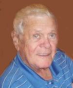
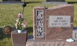

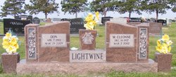
Donald Leroy “Don” Lightwine
| Birth | : | 7 Apr 1933 Orson, Harrison County, Iowa, USA |
| Death | : | 28 Mar 2009 Aurora, Hamilton County, Nebraska, USA |
| Burial | : | Queenstown Lyell Cemetery, Queenstown, West Coast Council, Australia |
| Coordinate | : | -42.0966300, 145.5366610 |
| Description | : | Donald Leroy Lightwine, the son of Stephen and Blanche Susan (Straight) Lightwine, was born in Orson, Iowa on April 7, 1933 and died in Aurora, Nebraska on March 28, 2009, at the age of 75. Don attended school in Orson through the 8th grade. He then worked on the family farm, boxed in Golden Gloves and competed at rodeos. Don served in the U.S. Navy during the Korean War on the U.S.S. Pittsburgh, before he was honorably discharged. Donald was united in marriage to Margaret Cleonne Pollard on January 30, 1956, at Laverne, Minnesota. After they were married... Read More |
frequently asked questions (FAQ):
-
Where is Donald Leroy “Don” Lightwine's memorial?
Donald Leroy “Don” Lightwine's memorial is located at: Queenstown Lyell Cemetery, Queenstown, West Coast Council, Australia.
-
When did Donald Leroy “Don” Lightwine death?
Donald Leroy “Don” Lightwine death on 28 Mar 2009 in Aurora, Hamilton County, Nebraska, USA
-
Where are the coordinates of the Donald Leroy “Don” Lightwine's memorial?
Latitude: -42.0966300
Longitude: 145.5366610
Family Members:
Parent

Spouse
Siblings
Flowers:


Nearby Cemetories:
1. Queenstown Lyell Cemetery
Queenstown, West Coast Council, Australia
Coordinate: -42.0966300, 145.5366610
2. Queenstown Pioneer Cemetery
Queenstown, West Coast Council, Australia
Coordinate: -42.0858800, 145.5494800
3. Linda Cemetery
Linda, West Coast Council, Australia
Coordinate: -42.0666656, 145.6000061
4. Strahan Cemetery
Strahan, West Coast Council, Australia
Coordinate: -42.1621150, 145.3273410
5. Zeehan Pioneer Cemetery
Zeehan, West Coast Council, Australia
Coordinate: -41.8958600, 145.3467730
6. Zeehan General Cemetery
Zeehan, West Coast Council, Australia
Coordinate: -41.8829930, 145.3149400
7. Williamsford-Rosebery Cemetery
Williamsford, West Coast Council, Australia
Coordinate: -41.7961920, 145.5232900
8. Tullah
Tullah, West Coast Council, Australia
Coordinate: -41.7440950, 145.6146170
9. Corinna Cemetery
Corinna, Waratah-Wynyard Council, Australia
Coordinate: -41.6509770, 145.0783630
10. Waratah Lawn Cemetery
Waratah, Waratah-Wynyard Council, Australia
Coordinate: -41.4590340, 145.5212690
11. Waratah Pioneer Cemetery
Guildford Junction, Waratah-Wynyard Council, Australia
Coordinate: -41.4489490, 145.5709770
12. Lorinna Cemetery
Lorinna, Kentish Council, Australia
Coordinate: -41.5477800, 146.1345900
13. Mole Creek General and Lawn Cemetery
Mole Creek, Meander Valley Council, Australia
Coordinate: -41.5703200, 146.4055750
14. Western Creek Cemetery
Meander Valley Council, Australia
Coordinate: -41.6394750, 146.4960280
15. Wilmot Cemetery
Wilmot, Kentish Council, Australia
Coordinate: -41.3837350, 146.1871690
16. Claude Road Cemetery
Claude Road, Kentish Council, Australia
Coordinate: -41.4322840, 146.2871020
17. George Woodhouse Lookout
Riana, Central Coast Council, Australia
Coordinate: -41.2818184, 145.9948120
18. Chudleigh Presbyterian Cemetery
Chudleigh, Meander Valley Council, Australia
Coordinate: -41.5632480, 146.4863430
19. Chudleigh Cemetery
Chudleigh, Meander Valley Council, Australia
Coordinate: -41.5532600, 146.4788000
20. Beamont Grave
Miena, Central Highlands Council, Australia
Coordinate: -41.9796086, 146.7257027
21. Meander Cemetery
Meander, Meander Valley Council, Australia
Coordinate: -41.6493140, 146.6173550
22. St. James' Anglican Church Cemetery
Osterley, Central Highlands Council, Australia
Coordinate: -42.3376920, 146.7364740
23. South Riana Uniting Church Cemetery
Central Coast Council, Australia
Coordinate: -41.2351280, 145.9792410
24. Sheffield Cemetery
Sheffield, Kentish Council, Australia
Coordinate: -41.3726558, 146.3055161