
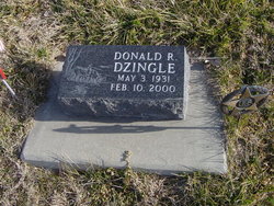
Donald Rayfield “Don” Dzingle
| Birth | : | 3 May 1931 Loup City, Sherman County, Nebraska, USA |
| Death | : | 10 Feb 2000 Ashton, Sherman County, Nebraska, USA |
| Burial | : | Strood Cemetery, Strood, Medway Unitary Authority, England |
| Coordinate | : | 51.3900220, 0.4838640 |
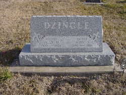
| Description | : | Son of John & Sally (Stanczyk) Dzingle. Married to Vonnie Yax on 7-2-1955 at Scotia, NE. The couple lived in Loup City where he operated the Standard Filling Station and drove the delivery tank wagon for many years. In the early 1960s he became an insurance agent for State Farm Insurance. He continued to sell insurance until retiring in 1996. For many years he played in bands including Musical Hot Shots, Country Troubadors and Big D Country. US Army Veteran |
frequently asked questions (FAQ):
-
Where is Donald Rayfield “Don” Dzingle's memorial?
Donald Rayfield “Don” Dzingle's memorial is located at: Strood Cemetery, Strood, Medway Unitary Authority, England.
-
When did Donald Rayfield “Don” Dzingle death?
Donald Rayfield “Don” Dzingle death on 10 Feb 2000 in Ashton, Sherman County, Nebraska, USA
-
Where are the coordinates of the Donald Rayfield “Don” Dzingle's memorial?
Latitude: 51.3900220
Longitude: 0.4838640
Family Members:
Parent

Siblings

Children
Flowers:


Nearby Cemetories:
1. Strood Cemetery
Strood, Medway Unitary Authority, England
Coordinate: 51.3900220, 0.4838640
2. St Nicholas with St Mary Churchyard
Strood, Medway Unitary Authority, England
Coordinate: 51.3959790, 0.4931350
3. St Margaret Churchyard
Rochester, Medway Unitary Authority, England
Coordinate: 51.3849380, 0.4993630
4. Rochester Castle Moat Burial Ground
Rochester, Medway Unitary Authority, England
Coordinate: 51.3894140, 0.5024580
5. Rochester Cathedral
Rochester, Medway Unitary Authority, England
Coordinate: 51.3889750, 0.5031160
6. St Nicholas Churchyard
Rochester, Medway Unitary Authority, England
Coordinate: 51.3894170, 0.5035320
7. Rochester Baptist Church
Rochester, Medway Unitary Authority, England
Coordinate: 51.3871570, 0.5052370
8. St. Margaret's Cemetery
Rochester, Medway Unitary Authority, England
Coordinate: 51.3777000, 0.5011600
9. St Matthew Churchyard
Borstal, Medway Unitary Authority, England
Coordinate: 51.3736150, 0.4868020
10. St. Nicholas's Cemetery
Rochester, Medway Unitary Authority, England
Coordinate: 51.3780081, 0.5021076
11. All Saints Churchyard
Frindsbury, Medway Unitary Authority, England
Coordinate: 51.4004440, 0.5058970
12. Fort Pitt Military Cemetery
Rochester, Medway Unitary Authority, England
Coordinate: 51.3769790, 0.5114570
13. Chatham Unitarian Church
Chatham, Medway Unitary Authority, England
Coordinate: 51.3826090, 0.5195850
14. St Mary Churchyard
Chatham, Medway Unitary Authority, England
Coordinate: 51.3874550, 0.5244280
15. St. Michael and All Angels Churchyard
Cuxton, Medway Unitary Authority, England
Coordinate: 51.3714120, 0.4546760
16. Chatham Burial Ground
Chatham, Medway Unitary Authority, England
Coordinate: 51.3849900, 0.5272600
17. Brompton War Memorial
Chatham, Medway Unitary Authority, England
Coordinate: 51.3932140, 0.5293660
18. St John Evangelist Churchyard
Higham, Gravesham Borough, England
Coordinate: 51.4162102, 0.4616890
19. Chatham Naval Memorial
Chatham, Medway Unitary Authority, England
Coordinate: 51.3836479, 0.5321670
20. Chatham Maidstone Road Cemetery
Chatham, Medway Unitary Authority, England
Coordinate: 51.3703300, 0.5227600
21. St George Churchyard
Chatham, Medway Unitary Authority, England
Coordinate: 51.3974070, 0.5346770
22. St Philip and St James Churchyard
Upnor, Medway Unitary Authority, England
Coordinate: 51.4106250, 0.5250480
23. Chatham Palmerston Road Cemetery
Chatham, Medway Unitary Authority, England
Coordinate: 51.3678600, 0.5267300
24. All Saints Churchyard
Wouldham, Tonbridge and Malling Borough, England
Coordinate: 51.3528130, 0.4580580