
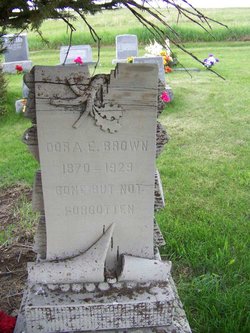
Dora E. Brown Campbell
| Birth | : | 1870 Johnson County, Missouri, USA |
| Death | : | 1929 Applegate, Jackson County, Oregon, USA |
| Burial | : | Saint Marys Cemetery, Carey, Wyandot County, USA |
| Coordinate | : | 40.9641991, -83.3780975 |
| Description | : | From the Stillwater "Enterprise", Absarokee, Thursday, 10 January 1929: Popular Pioneer Matron at Rest Remains Interred at Roscoe The accidental shooting of Mrs. Dora Campbell at her home at Applegate, Oregon, last Thursday night, which came as a last minute announcement to the Enterprise resulted in a great shock to her many friends in Stillwater, Carbon and Park counties, especially Stillwater, where she had made her home for so many years. It seems Cullen the youngest boy, was cleaning a twenty two rifle in the kitchen of the home while Mrs. Campbell was attending to the usual housework when the gun exploded the... Read More |
frequently asked questions (FAQ):
-
Where is Dora E. Brown Campbell's memorial?
Dora E. Brown Campbell's memorial is located at: Saint Marys Cemetery, Carey, Wyandot County, USA.
-
When did Dora E. Brown Campbell death?
Dora E. Brown Campbell death on 1929 in Applegate, Jackson County, Oregon, USA
-
Where are the coordinates of the Dora E. Brown Campbell's memorial?
Latitude: 40.9641991
Longitude: -83.3780975
Family Members:
Parent
Spouse
Children

Flowers:


Nearby Cemetories:
1. Saint Marys Cemetery
Carey, Wyandot County, USA
Coordinate: 40.9641991, -83.3780975
2. Spring Grove Cemetery
Carey, Wyandot County, USA
Coordinate: 40.9696999, -83.3824997
3. Carey Association Cemetery
Carey, Wyandot County, USA
Coordinate: 40.9488857, -83.3802392
4. Baker Cemetery
Carey, Wyandot County, USA
Coordinate: 40.9730988, -83.3324966
5. Old Lutheran Ridge Cemetery
Carey, Wyandot County, USA
Coordinate: 40.9762050, -83.4263990
6. Big Spring Cemetery
Seneca County, USA
Coordinate: 41.0032997, -83.3874969
7. Lutheran Ridge Cemetery
Wyandot County, USA
Coordinate: 40.9810982, -83.4289017
8. England Cemetery
Carey, Wyandot County, USA
Coordinate: 40.9211006, -83.4002991
9. Pleasant Ridge Cemetery
Wyandot County, USA
Coordinate: 40.9766998, -83.4375000
10. McKenzie Cemetery
Crawford, Wyandot County, USA
Coordinate: 40.9853860, -83.3191660
11. Ritchy-Crawford Cemetery
Crawford, Wyandot County, USA
Coordinate: 40.9233800, -83.3288000
12. Smith Cemetery
Crawford, Wyandot County, USA
Coordinate: 40.9432150, -83.3053030
13. Berry Cemetery
Tymochtee, Wyandot County, USA
Coordinate: 40.9458810, -83.3005580
14. Beaver Cemetery
Tymochtee, Wyandot County, USA
Coordinate: 40.9440640, -83.3009850
15. Hetzel Cemetery
Wyandot County, USA
Coordinate: 40.9366100, -83.3010800
16. Kear Cemetery
Tymochtee, Wyandot County, USA
Coordinate: 40.9528300, -83.2888100
17. Dunaway Cemetery
Lovell, Wyandot County, USA
Coordinate: 40.8975220, -83.3987190
18. Hickory Grove Cemetery
Vanlue, Hancock County, USA
Coordinate: 41.0028000, -83.4533005
19. Saint Nicholas Catholic Cemetery
Frenchtown, Seneca County, USA
Coordinate: 41.0280610, -83.3429880
20. Gibson Cemetery
Tymochtee, Wyandot County, USA
Coordinate: 40.9328520, -83.2934010
21. Dunn Cemetery
Wyandot County, USA
Coordinate: 40.9766998, -83.2742004
22. Wentz Cemetery
Wharton, Wyandot County, USA
Coordinate: 40.8899994, -83.4246979
23. Zion Bloom Cemetery
Vanlue, Hancock County, USA
Coordinate: 40.9474983, -83.4869003
24. Cole Cemetery
Carey, Wyandot County, USA
Coordinate: 40.9011716, -83.4528978