

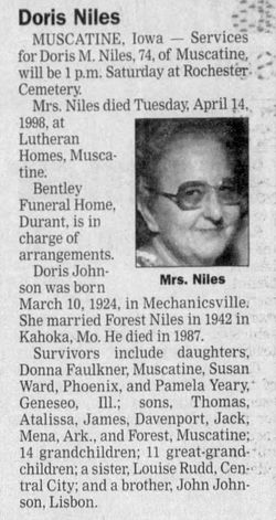
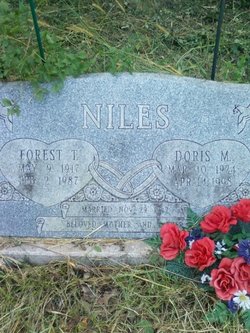
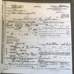
Doris Mae Johnson Niles
| Birth | : | 10 Mar 1924 Mechanicsville, Cedar County, Iowa, USA |
| Death | : | 14 Apr 1998 Muscatine, Muscatine County, Iowa, USA |
| Burial | : | All Saints Churchyard, Lullington, Mendip District, England |
| Coordinate | : | 51.2661940, -2.3121800 |
frequently asked questions (FAQ):
-
Where is Doris Mae Johnson Niles's memorial?
Doris Mae Johnson Niles's memorial is located at: All Saints Churchyard, Lullington, Mendip District, England.
-
When did Doris Mae Johnson Niles death?
Doris Mae Johnson Niles death on 14 Apr 1998 in Muscatine, Muscatine County, Iowa, USA
-
Where are the coordinates of the Doris Mae Johnson Niles's memorial?
Latitude: 51.2661940
Longitude: -2.3121800
Family Members:
Parent

Spouse
Siblings
Children
Flowers:


Nearby Cemetories:
1. All Saints Churchyard
Lullington, Mendip District, England
Coordinate: 51.2661940, -2.3121800
2. St Mary's Churchyard
Laverton, Mendip District, England
Coordinate: 51.2757380, -2.3195910
3. St Mary the Virgin Churchyard
Orchardleigh, Mendip District, England
Coordinate: 51.2576210, -2.3259440
4. Beckington Baptist Chapel Burial Ground
Beckington, Mendip District, England
Coordinate: 51.2610760, -2.2897000
5. St George Churchyard
Beckington, Mendip District, England
Coordinate: 51.2635260, -2.2856810
6. St. Lawrence Churchyard
Woolverton, Mendip District, England
Coordinate: 51.2851540, -2.3021790
7. Saint Michael & All Angels Churchyard
Buckland Dinham, Mendip District, England
Coordinate: 51.2600540, -2.3522580
8. St Lawrence Churchyard
Rode, Mendip District, England
Coordinate: 51.2792750, -2.2765370
9. Christ Church Churchyard
Rode, Mendip District, England
Coordinate: 51.2861620, -2.2790890
10. Holy Trinity Church
Frome, Mendip District, England
Coordinate: 51.2341720, -2.3275820
11. St. Mary's Berkley
Berkley, Mendip District, England
Coordinate: 51.2435080, -2.2720990
12. Frome Dissenters' Cemetery
Frome, Mendip District, England
Coordinate: 51.2317000, -2.3215000
13. Norton St. Philip Churchyard
Norton St Philip, Mendip District, England
Coordinate: 51.3001680, -2.3279700
14. All Saints Churchyard
Tellisford, Mendip District, England
Coordinate: 51.2997270, -2.2877180
15. St. John the Baptist Churchyard
Frome, Mendip District, England
Coordinate: 51.2296780, -2.3209480
16. Sheppards Barton Meeting House Burial Ground
Frome, Mendip District, England
Coordinate: 51.2300570, -2.3247620
17. Christ Church Churchyard
Frome, Mendip District, England
Coordinate: 51.2295340, -2.3260130
18. East Hill Cemetery
Frome, Mendip District, England
Coordinate: 51.2275940, -2.3030250
19. East Hill
Frome St Quintin, West Dorset District, England
Coordinate: 51.2272132, -2.3024896
20. All Saints Churchyard
Rodden, Mendip District, England
Coordinate: 51.2283600, -2.2892740
21. Saint Mary Magdalene Churchyard
Great Elm, Mendip District, England
Coordinate: 51.2426040, -2.3647230
22. Blessed St Mary the Virgin Churchyard
Hemington, Mendip District, England
Coordinate: 51.2758698, -2.3925455
23. St Leonard Churchyard
Farleigh Hungerford, Mendip District, England
Coordinate: 51.3155390, -2.2884820
24. Farleigh Hungerford Castle
Farleigh Hungerford, Mendip District, England
Coordinate: 51.3173500, -2.2869590