
| Memorials | : | 0 |
| Location | : | Frome, Mendip District, England |
| Coordinate | : | 51.2300570, -2.3247620 |
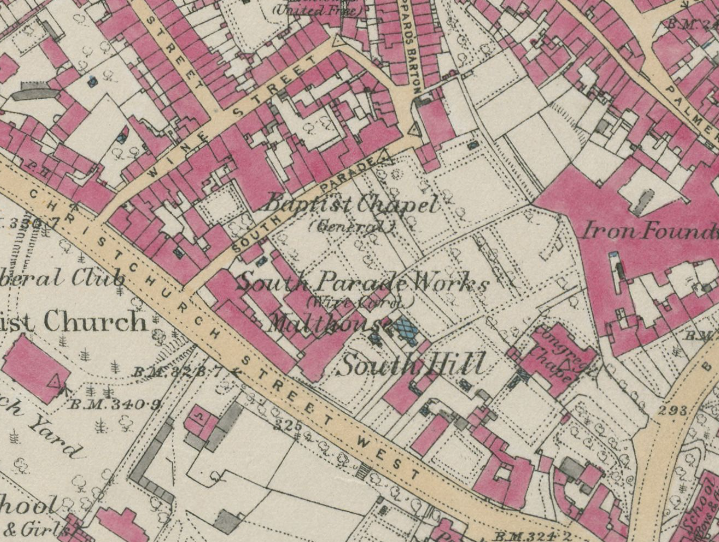
| Description | : | Baptist chapel in Sheppards Barton, dating from 1705, but rebuilt in 1850 and seating about 530. The rebuilt church was closed in 2001. The burial grounds were situated in front of the original meeting house. Plan of the burial grounds can be found on page 8 of the Burial Registers sourced here: Piece Title: Piece 3263: Frome, Sheppards Barton Meeting House (Baptist), 1750-1837 Source Information Ancestry.com. England & Wales, Non-Conformist and Non-Parochial Registers, 1567-1936 [database on-line]. Provo, UT, USA: Ancestry.com Operations, Inc., 2013. Original data:General Register Office: Registers of Births, Marriages and Deaths surrendered to the Non-parochial Registers Commissions of 1837 and 1857. Records of... Read More |
frequently asked questions (FAQ):
-
Where is Sheppards Barton Meeting House Burial Ground?
Sheppards Barton Meeting House Burial Ground is located at South Parade, Frome, Somerset Frome, Mendip District ,Somerset , BA11 1ELEngland.
-
Sheppards Barton Meeting House Burial Ground cemetery's updated grave count on graveviews.com?
0 memorials
-
Where are the coordinates of the Sheppards Barton Meeting House Burial Ground?
Latitude: 51.2300570
Longitude: -2.3247620
Nearby Cemetories:
1. Christ Church Churchyard
Frome, Mendip District, England
Coordinate: 51.2295340, -2.3260130
2. St. John the Baptist Churchyard
Frome, Mendip District, England
Coordinate: 51.2296780, -2.3209480
3. Frome Dissenters' Cemetery
Frome, Mendip District, England
Coordinate: 51.2317000, -2.3215000
4. Holy Trinity Church
Frome, Mendip District, England
Coordinate: 51.2341720, -2.3275820
5. East Hill Cemetery
Frome, Mendip District, England
Coordinate: 51.2275940, -2.3030250
6. East Hill
Frome St Quintin, West Dorset District, England
Coordinate: 51.2272132, -2.3024896
7. All Saints Churchyard
Rodden, Mendip District, England
Coordinate: 51.2283600, -2.2892740
8. St Mary the Virgin Churchyard
Orchardleigh, Mendip District, England
Coordinate: 51.2576210, -2.3259440
9. Saint Mary Magdalene Churchyard
Great Elm, Mendip District, England
Coordinate: 51.2426040, -2.3647230
10. St Leonard Church
Marston Magna, South Somerset District, England
Coordinate: 51.2058070, -2.3488020
11. St. Leonard's Churchyard
Mendip District, England
Coordinate: 51.2033660, -2.3512620
12. Saint Michael & All Angels Churchyard
Buckland Dinham, Mendip District, England
Coordinate: 51.2600540, -2.3522580
13. St. Mary's Berkley
Berkley, Mendip District, England
Coordinate: 51.2435080, -2.2720990
14. St George's Churchyard
Whatley, Mendip District, England
Coordinate: 51.2270030, -2.3822140
15. All Saints Churchyard
Lullington, Mendip District, England
Coordinate: 51.2661940, -2.3121800
16. Byfields Cemetery
Nunney, Mendip District, England
Coordinate: 51.2077210, -2.3722630
17. St. Katherine's Churchyard
Frome, Mendip District, England
Coordinate: 51.1957520, -2.3012529
18. Beckington Baptist Chapel Burial Ground
Beckington, Mendip District, England
Coordinate: 51.2610760, -2.2897000
19. All Saints Churchyard
Nunney, Mendip District, England
Coordinate: 51.2098694, -2.3772340
20. St George Churchyard
Beckington, Mendip District, England
Coordinate: 51.2635260, -2.2856810
21. St Andrew Churchyard
Mells, Mendip District, England
Coordinate: 51.2420710, -2.3912060
22. St Mary's Churchyard
Laverton, Mendip District, England
Coordinate: 51.2757380, -2.3195910
23. St. Margaret Churchyard Extension
Corsley, Wiltshire Unitary Authority, England
Coordinate: 51.2191491, -2.2469419
24. St. Mary's Churchyard
Mendip District, England
Coordinate: 51.1942400, -2.3928700