

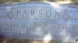
Doris Marie Guhlow Baerwald
| Birth | : | 15 Oct 1910 Tripoli, Bremer County, Iowa, USA |
| Death | : | 29 Jul 2004 Cedar Falls, Black Hawk County, Iowa, USA |
| Burial | : | Oakland Grove Cemetery, Bourne, Barnstable County, USA |
| Coordinate | : | 41.7402992, -70.6042023 |
| Description | : | DORIS M. BAERWALD, 93, of Cedar Falls, Iowa, died Thursday, July 29, 2004, at Cedar Falls Health Care Center. Doris was born October 15, 1910 at Tripoli, Iowa, the daughter of Charles and Alma (Mahlstedt) Guhlow. She married Harry Parson in 1927. He preceded her in death in 1950. Doris married Warner "Doc" Baerwald on December 2, 1961. He died May 19, 1968. Doris was a member of Nazareth Lutheran Church in Cedar Falls and was an avid volunteer with many local organizations. She is survived by her... Read More |
frequently asked questions (FAQ):
-
Where is Doris Marie Guhlow Baerwald's memorial?
Doris Marie Guhlow Baerwald's memorial is located at: Oakland Grove Cemetery, Bourne, Barnstable County, USA.
-
When did Doris Marie Guhlow Baerwald death?
Doris Marie Guhlow Baerwald death on 29 Jul 2004 in Cedar Falls, Black Hawk County, Iowa, USA
-
Where are the coordinates of the Doris Marie Guhlow Baerwald's memorial?
Latitude: 41.7402992
Longitude: -70.6042023
Family Members:
Parent

Spouse
Children
Flowers:


Nearby Cemetories:
1. Old Bourne Cemetery
Bourne, Barnstable County, USA
Coordinate: 41.7386017, -70.5986023
2. Bourne Village Cemetery
Bourne, Barnstable County, USA
Coordinate: 41.7425117, -70.5938110
3. Monument Neck Cemetery
Gray Gables, Barnstable County, USA
Coordinate: 41.7346001, -70.6128006
4. Bourne Family Cemetery
Bourne, Barnstable County, USA
Coordinate: 41.7501602, -70.6032104
5. Bourne Family Cemetery #02
Bourne, Barnstable County, USA
Coordinate: 41.7577230, -70.6001190
6. Long Neck Cemetery
Wareham, Plymouth County, USA
Coordinate: 41.7461014, -70.6369019
7. Monument Beach Cemetery
Monument Beach, Barnstable County, USA
Coordinate: 41.7151800, -70.6094600
8. Nickerson Burial Ground
Plymouth, Plymouth County, USA
Coordinate: 41.7642740, -70.6306530
9. Pocasset Cemetery
Bourne, Barnstable County, USA
Coordinate: 41.6947260, -70.6034070
10. Bournedale Burying Hill
Bourne, Barnstable County, USA
Coordinate: 41.7741520, -70.5611730
11. Bournedale Herring Pond Indian Cemetery
Bourne, Barnstable County, USA
Coordinate: 41.7861900, -70.5658722
12. Herring Pond Wampanoag Indian Cemetery
Plymouth, Plymouth County, USA
Coordinate: 41.7867290, -70.5658940
13. Sagamore Cemetery
Bourne, Barnstable County, USA
Coordinate: 41.7714005, -70.5339966
14. Cataumet Cemetery
Bourne, Barnstable County, USA
Coordinate: 41.6768990, -70.6063995
15. Agawam Cemetery
Wareham, Plymouth County, USA
Coordinate: 41.7463989, -70.6908035
16. Herring Pond Cemetery
Plymouth, Plymouth County, USA
Coordinate: 41.7971700, -70.5588800
17. Massachusetts National Cemetery
Bourne, Barnstable County, USA
Coordinate: 41.6759987, -70.5824966
18. Saddle and Pillion Cemetery
Sagamore, Barnstable County, USA
Coordinate: 41.7672005, -70.5192032
19. Bay View Cemetery
Sandwich, Barnstable County, USA
Coordinate: 41.7583008, -70.5102997
20. Saint Peters Cemetery
Sandwich, Barnstable County, USA
Coordinate: 41.7502480, -70.5079346
21. Freeman Cemetery
Sandwich, Barnstable County, USA
Coordinate: 41.7573013, -70.5083008
22. Cedarville Cemetery
Plymouth, Plymouth County, USA
Coordinate: 41.8049736, -70.5560837
23. Old Town Cemetery
Sandwich, Barnstable County, USA
Coordinate: 41.7556992, -70.5011978
24. Nightingale Cemetery
Plymouth, Plymouth County, USA
Coordinate: 41.8113400, -70.5588260