

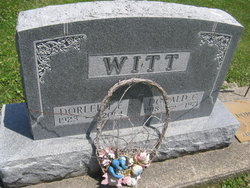
Dorleen Emma Aulerich Witt
| Birth | : | 26 Mar 1923 Luana, Clayton County, Iowa, USA |
| Death | : | 6 May 2014 Cedar Falls, Black Hawk County, Iowa, USA |
| Burial | : | Elkader Cemetery, Elkader, Clayton County, USA |
| Coordinate | : | 42.8541718, -91.4000015 |
| Description | : | Dorleen E. Witt, 91, of Cedar Falls, Iowa and formerly of Oelwein, Iowa died on Tuesday morning, May 6, 2014 at the Martin Health Center of the Western Home in Cedar Falls, Iowa. Funeral Services: 10:00 A.M. on Saturday, May 10, 2014 at the Jamison-Schmitz Funeral Home in Oelwein, Iowa; Officiating: Rev. Ruth Ratliff; Visitation: from 4:00 P.M. to 7:00 P.M. on Friday at the funeral home and after 9:00 A.M. on Saturday; Interment: Eastside Cemetery at Elkader, Iowa at 12 Noon on Saturday. Memorials may be given in her name to the Cedar Bend Humane Society, the Western Home Foundation or... Read More |
frequently asked questions (FAQ):
-
Where is Dorleen Emma Aulerich Witt's memorial?
Dorleen Emma Aulerich Witt's memorial is located at: Elkader Cemetery, Elkader, Clayton County, USA.
-
When did Dorleen Emma Aulerich Witt death?
Dorleen Emma Aulerich Witt death on 6 May 2014 in Cedar Falls, Black Hawk County, Iowa, USA
-
Where are the coordinates of the Dorleen Emma Aulerich Witt's memorial?
Latitude: 42.8541718
Longitude: -91.4000015
Family Members:

Flowers:


Nearby Cemetories:
1. Elkader Cemetery
Elkader, Clayton County, USA
Coordinate: 42.8541718, -91.4000015
2. Saint Josephs Cemetery
Elkader, Clayton County, USA
Coordinate: 42.8488998, -91.4021988
3. Hartman Cemetery
Cox Creek Township, Clayton County, USA
Coordinate: 42.8155360, -91.3880840
4. Colony Catholic Cemetery (Defunct)
Read Township, Clayton County, USA
Coordinate: 42.8830000, -91.3580000
5. County Home Cemetery
Clayton Center, Clayton County, USA
Coordinate: 42.8916702, -91.3499985
6. Dohrer Cemetery
Osborne, Clayton County, USA
Coordinate: 42.8124846, -91.4584734
7. Meenan Cemetery
Communia, Clayton County, USA
Coordinate: 42.7999862, -91.3584693
8. Zion Lutheran Cemetery
Clayton Center, Clayton County, USA
Coordinate: 42.8841705, -91.3249969
9. Cords Cemetery
Osborne, Clayton County, USA
Coordinate: 42.7973308, -91.4377662
10. Clayton Center Cemetery
Clayton Center, Clayton County, USA
Coordinate: 42.8841705, -91.3225021
11. Communia Cemetery
Volga Township, Clayton County, USA
Coordinate: 42.7868996, -91.3630981
12. Patterson Pioneer Cemetery
Saint Olaf, Clayton County, USA
Coordinate: 42.9216000, -91.4489000
13. Watkins Cemetery
Osborne, Clayton County, USA
Coordinate: 42.7833180, -91.4584733
14. Clark Family Cemetery
Beulah, Clayton County, USA
Coordinate: 42.9166505, -91.4751415
15. Norway Lutheran Church Cemetery
Saint Olaf, Clayton County, USA
Coordinate: 42.9352798, -91.4302826
16. Weymouth Cemetery
Saint Olaf, Clayton County, USA
Coordinate: 42.9278799, -91.4583559
17. Mederville Cemetery
Elkader, Clayton County, USA
Coordinate: 42.7638893, -91.4194412
18. Krumm Cemetery
Garber, Clayton County, USA
Coordinate: 42.7913760, -91.3023559
19. Farmersburg-Wagner Cemetery
Farmersburg, Clayton County, USA
Coordinate: 42.9481010, -91.3700027
20. Blanchaine Cemetery
Volga, Clayton County, USA
Coordinate: 42.7676210, -91.3389040
21. Cook Family Cemetery
Elkader, Clayton County, USA
Coordinate: 42.9209880, -91.5091230
22. Wagner Township Cemetery
Saint Olaf, Clayton County, USA
Coordinate: 42.9519386, -91.4513931
23. Eberhard Cemetery
Littleport, Clayton County, USA
Coordinate: 42.7583201, -91.3418020
24. Highland Lutheran Cemetery
Highland Township, Clayton County, USA
Coordinate: 42.8987000, -91.5330000