
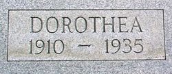
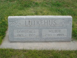
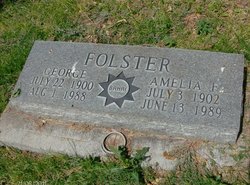
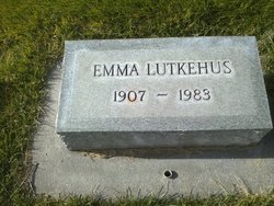
Dorothea Folster Lutkehus
| Birth | : | 1 Feb 1910 Garden County, Nebraska, USA |
| Death | : | 1 Jan 1935 Sidney, Cheyenne County, Nebraska, USA |
| Burial | : | Droylsden Cemetery, Droylsden, Metropolitan Borough of Tameside, England |
| Coordinate | : | 53.4849400, -2.1529696 |
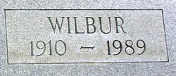
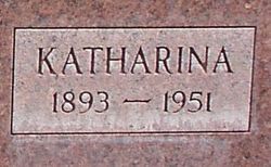
| Description | : | Dorothea Folster, daughter of Chiris and Katherine Louise Folster was born February 1, 1910 in Garden County, Nebraska, and departed this life at Sidney Nebraska January 1, 1935 at the age of 24 years and 11 months. She spent her entire childhood days in Garden county where she grew to womanhood attending the district schools and was since infancy connected with the Lutheran Church. On January 17, 1934 she was united in marriage to Wilbur Lutkehus of Chappell, Nebraska. The young couple established their first home southeast of Chappell, where they have since resided. On December 19, 1934 a baby... Read More |
frequently asked questions (FAQ):
-
Where is Dorothea Folster Lutkehus's memorial?
Dorothea Folster Lutkehus's memorial is located at: Droylsden Cemetery, Droylsden, Metropolitan Borough of Tameside, England.
-
When did Dorothea Folster Lutkehus death?
Dorothea Folster Lutkehus death on 1 Jan 1935 in Sidney, Cheyenne County, Nebraska, USA
-
Where are the coordinates of the Dorothea Folster Lutkehus's memorial?
Latitude: 53.4849400
Longitude: -2.1529696
Family Members:
Parent
Spouse
Siblings
Flowers:


Nearby Cemetories:
1. Droylsden Cemetery
Droylsden, Metropolitan Borough of Tameside, England
Coordinate: 53.4849400, -2.1529696
2. St Cross Churchyard
Clayton, Metropolitan Borough of Manchester, England
Coordinate: 53.4832190, -2.1823530
3. Failsworth Cemetery
Failsworth, Metropolitan Borough of Oldham, England
Coordinate: 53.5048760, -2.1537550
4. Failsworth Jewish Cemetery
Failsworth, Metropolitan Borough of Oldham, England
Coordinate: 53.5050270, -2.1534220
5. All Saints Churchyard
Newton Heath, Metropolitan Borough of Manchester, England
Coordinate: 53.5002260, -2.1777970
6. Saint Stephens Churchyard
Audenshaw, Metropolitan Borough of Tameside, England
Coordinate: 53.4753000, -2.1151700
7. St. Peter's Churchyard
Ashton-Under-Lyne, Metropolitan Borough of Tameside, England
Coordinate: 53.4839340, -2.1054690
8. Philips Park Cemetery
Miles Platting, Metropolitan Borough of Manchester, England
Coordinate: 53.4898020, -2.2007400
9. Gorton Cemetery
Manchester, Metropolitan Borough of Manchester, England
Coordinate: 53.4567080, -2.1632580
10. Audenshaw Cemetery
Audenshaw, Metropolitan Borough of Tameside, England
Coordinate: 53.4653300, -2.1101560
11. Oldham Crematorium
Oldham, Metropolitan Borough of Oldham, England
Coordinate: 53.5156810, -2.1332800
12. Christ Church Churchyard
Denton, Metropolitan Borough of Tameside, England
Coordinate: 53.4560270, -2.1218270
13. Hollinwood Cemetery
Oldham, Metropolitan Borough of Oldham, England
Coordinate: 53.5178170, -2.1329170
14. Saint Mary's Churchyard
Moston, Metropolitan Borough of Manchester, England
Coordinate: 53.5181740, -2.1763410
15. St. Joseph's Roman Catholic Churchyard
Moston, Metropolitan Borough of Manchester, England
Coordinate: 53.5149270, -2.1877070
16. Dukinfield Cemetery and Crematorium
Dukinfield, Metropolitan Borough of Tameside, England
Coordinate: 53.4800300, -2.0857150
17. Former Saint Johns Churchyard
Longsight, Metropolitan Borough of Manchester, England
Coordinate: 53.4570760, -2.2025800
18. St Lawrence Church
Denton, Metropolitan Borough of Tameside, England
Coordinate: 53.4520000, -2.1109000
19. All Saints Churchyard
Chorlton-on-Medlock, Metropolitan Borough of Manchester, England
Coordinate: 53.4666670, -2.2166670
20. Manchester General Cemetery
Manchester, Metropolitan Borough of Manchester, England
Coordinate: 53.5062710, -2.2179570
21. St Thomas Churchyard
Ardwick, Metropolitan Borough of Manchester, England
Coordinate: 53.4720000, -2.2248900
22. Christchurch Harpurhey Churchyard
Harpurhey, Metropolitan Borough of Manchester, England
Coordinate: 53.5115100, -2.2134800
23. St. John the Evangelist Churchyard
Hurst, Metropolitan Borough of Tameside, England
Coordinate: 53.5001310, -2.0812490
24. St Elisabeth Church
Reddish, Metropolitan Borough of Stockport, England
Coordinate: 53.4379400, -2.1633950