
| Birth | : | 24 May 1912 Whatcom County, Washington, USA |
| Death | : | 9 Oct 1991 Pasco, Franklin County, Washington, USA |
| Burial | : | Green Hills Memorial Park, Rancho Palos Verdes, Los Angeles County, USA |
| Coordinate | : | 33.7731018, -118.3133011 |
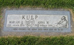
| Description | : | Dorothy is the daughter of John Jacob Kulp and Mary Emily McPhail Kulp. She was married to James Fred Kenoyer. He preceded her in death in 1964. She later married Charles R. Hooper and he preceded her in death on June 29, 1978. Washington Death Index Name: Dorothy B Hooper Date of Death: 9 Oct 1991 Place of Death: Pasco Age: 79 Estimated Birth Year: abt 1912 RESIDENCE: Franklin Gender: Female Certificate: 026702 |
frequently asked questions (FAQ):
-
Where is Dorothy Belle Kulp Kenoyer's memorial?
Dorothy Belle Kulp Kenoyer's memorial is located at: Green Hills Memorial Park, Rancho Palos Verdes, Los Angeles County, USA.
-
When did Dorothy Belle Kulp Kenoyer death?
Dorothy Belle Kulp Kenoyer death on 9 Oct 1991 in Pasco, Franklin County, Washington, USA
-
Where are the coordinates of the Dorothy Belle Kulp Kenoyer's memorial?
Latitude: 33.7731018
Longitude: -118.3133011
Family Members:
Parent

Spouse
Siblings
Children
Flowers:


Nearby Cemetories:
1. Green Hills Memorial Park
Rancho Palos Verdes, Los Angeles County, USA
Coordinate: 33.7731018, -118.3133011
2. South Coast Botanical Garden
Palos Verdes Estates, Los Angeles County, USA
Coordinate: 33.7844800, -118.3480100
3. Saint Peters Episcopal Church Columbarium
San Pedro, Los Angeles County, USA
Coordinate: 33.7370500, -118.3136400
4. Saint John Fisher Columbarium
Rancho Palos Verdes, Los Angeles County, USA
Coordinate: 33.7626800, -118.3693600
5. Drum Barracks Cemetery (Defunct)
Wilmington, Los Angeles County, USA
Coordinate: 33.7855320, -118.2533170
6. Wilmington Cemetery
Wilmington, Los Angeles County, USA
Coordinate: 33.7922300, -118.2550900
7. Harbor View Cemetery
San Pedro, Los Angeles County, USA
Coordinate: 33.7221240, -118.2901410
8. First Lutheran Church and School
Torrance, Los Angeles County, USA
Coordinate: 33.8310400, -118.3388000
9. K-9 Command Cemetery
San Pedro, Los Angeles County, USA
Coordinate: 33.7119636, -118.2961824
10. Saint Lawrence Martyr Church Columbarium
Redondo Beach, Los Angeles County, USA
Coordinate: 33.8177012, -118.3767580
11. Roosevelt Memorial Park
Gardena, Los Angeles County, USA
Coordinate: 33.8643990, -118.2947006
12. Pet Haven Cemetery
Gardena, Los Angeles County, USA
Coordinate: 33.8642006, -118.2807999
13. Pacific Crest Cemetery
Redondo Beach, Los Angeles County, USA
Coordinate: 33.8675003, -118.3591995
14. Gardena Buddhist Church
Gardena, Los Angeles County, USA
Coordinate: 33.8804950, -118.3023170
15. Sunnyside Cemetery
Long Beach, Los Angeles County, USA
Coordinate: 33.8044700, -118.1789100
16. Long Beach Municipal Cemetery
Long Beach, Los Angeles County, USA
Coordinate: 33.8044700, -118.1769200
17. Saint Cross Episcopal Church Columbarium
Hermosa Beach, Los Angeles County, USA
Coordinate: 33.8673040, -118.3996600
18. Lincoln Memorial Park
Carson, Los Angeles County, USA
Coordinate: 33.8806000, -118.2521973
19. Woodlawn Memorial Park
Compton, Los Angeles County, USA
Coordinate: 33.8812700, -118.2468800
20. Forest Lawn Memorial Park
Long Beach, Los Angeles County, USA
Coordinate: 33.8436012, -118.1691971
21. All Saints Anglican Church Columbarium
Long Beach, Los Angeles County, USA
Coordinate: 33.7696600, -118.1461300
22. Palm Cemetery
Long Beach, Los Angeles County, USA
Coordinate: 33.8447200, -118.1682500
23. All Souls Cemetery
Long Beach, Los Angeles County, USA
Coordinate: 33.8405991, -118.1647034
24. Angeles Abbey Memorial Park
Compton, Los Angeles County, USA
Coordinate: 33.8982887, -118.2065582