
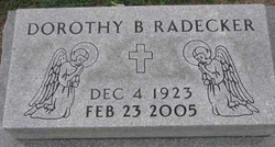
Dorothy Bertha Ross Radecker
| Birth | : | 4 Dec 1923 Cuming County, Nebraska, USA |
| Death | : | 23 Feb 2005 West Point, Cuming County, Nebraska, USA |
| Burial | : | Crane Creek Cemetery, Williston, Ottawa County, USA |
| Coordinate | : | 41.5802994, -83.3968964 |
| Description | : | Daughter of Daniel and Louise Koehler Ross. She was baptized and confirmed at Zion Lutheran Church near Bancroft. She is a 1941 graduate of Bancroft High School. Dorothy taught Cuming County Rural Schools until her November 8, 1947 marriage to Franklin Radecker at St. Paul Lutheran Church in West Point. Dorothy was involved in the County 4-H program serving as a leader for 17 years. In 1971, she became a member of the West Point Elementary staff as a Para-educator in the Special Ed Department for 22 years. Dorothy was a member of St. Paul Lutheran Church where she was... Read More |
frequently asked questions (FAQ):
-
Where is Dorothy Bertha Ross Radecker's memorial?
Dorothy Bertha Ross Radecker's memorial is located at: Crane Creek Cemetery, Williston, Ottawa County, USA.
-
When did Dorothy Bertha Ross Radecker death?
Dorothy Bertha Ross Radecker death on 23 Feb 2005 in West Point, Cuming County, Nebraska, USA
-
Where are the coordinates of the Dorothy Bertha Ross Radecker's memorial?
Latitude: 41.5802994
Longitude: -83.3968964
Family Members:
Parent

Spouse
Siblings

Flowers:


Nearby Cemetories:
1. Crane Creek Cemetery
Williston, Ottawa County, USA
Coordinate: 41.5802994, -83.3968964
2. Hillabrand Cemetery
Oregon, Lucas County, USA
Coordinate: 41.6200530, -83.4256350
3. Allen Township Cemetery
Williston, Ottawa County, USA
Coordinate: 41.6100006, -83.3396988
4. Lake Township Cemetery
Walbridge, Wood County, USA
Coordinate: 41.5892181, -83.4677124
5. Oak Wood Cemetery
Curtice, Lucas County, USA
Coordinate: 41.6242590, -83.3420000
6. Saint Ignatius Cemetery
Oregon, Lucas County, USA
Coordinate: 41.6564369, -83.4079895
7. Restlawn Memorial Park
Perrysburg, Wood County, USA
Coordinate: 41.5133018, -83.4661026
8. Willow Cemetery
Oregon, Lucas County, USA
Coordinate: 41.6292000, -83.4997025
9. Clay Township Cemetery
Genoa, Ottawa County, USA
Coordinate: 41.5092010, -83.3186035
10. Beth Shalom Cemetery
Oregon, Lucas County, USA
Coordinate: 41.6603300, -83.4713200
11. North Oregon Cemetery
Oregon, Lucas County, USA
Coordinate: 41.6613998, -83.4705963
12. Saint Johns Lutheran Church Cemetery
Toledo, Lucas County, USA
Coordinate: 41.6519920, -83.4897530
13. Elliston Cemetery
Elliston, Ottawa County, USA
Coordinate: 41.5439987, -83.2679977
14. Unnamed Cemetery #4 (Defunct)
Toledo, Lucas County, USA
Coordinate: 41.6434540, -83.5252720
15. Woodville Cemetery
Woodville, Sandusky County, USA
Coordinate: 41.4641991, -83.3625031
16. Woodville Catholic Cemetery
Woodville, Sandusky County, USA
Coordinate: 41.4621540, -83.3614250
17. Trinity Episcopal Columbarium
Toledo, Lucas County, USA
Coordinate: 41.6527470, -83.5331560
18. Rymers Cemetery
Elmore, Ottawa County, USA
Coordinate: 41.4833900, -83.2871690
19. Westwood Cemetery
Woodville, Sandusky County, USA
Coordinate: 41.4510994, -83.3861008
20. Harrington Cemetery
Elmore, Ottawa County, USA
Coordinate: 41.4781990, -83.2903100
21. Manhattan Cemetery
Toledo, Lucas County, USA
Coordinate: 41.6878117, -83.4964925
22. Caswell Cemetery
Rossford, Wood County, USA
Coordinate: 41.6146180, -83.5672210
23. Forest Cemetery
Toledo, Lucas County, USA
Coordinate: 41.6693130, -83.5293320
24. Unnamed Cemetery #3 (Defunct)
Toledo, Lucas County, USA
Coordinate: 41.6663240, -83.5334060